1960s Maps of Coal County, Oklahoma
Explore 11 historic maps of Coal County from the 1960s. These maps offer a rare glimpse into what life looked like during the 1960s — showing old roads, neighborhoods, homes, and landmarks that have changed or disappeared over time.
Whether you're researching your family's past, planning a metal detecting trip, or studying how Coal County's landscape evolved across the 1960s, these high-resolution maps are a powerful tool for exploring the history of this region.
- Focus on a specific era: All maps on this page are from the 1960s, giving you a focused view of this time period.
- See what’s changed: Compare century-old streets, trails, and buildings to today's modern landscape using overlays and satellite layers.
- Research with precision: Use these maps for genealogy, historical research, land use analysis, or educational projects.
- View, download, or print: Maps are fully viewable online in high resolution, and can be downloaded or printed for your own records.
Start exploring Coal County's history through authentic maps from the 1960s. This is your window into the past.
Coal County, OK maps
(11)- 1963 Map of Ardmore
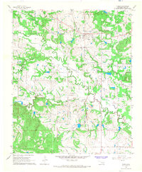
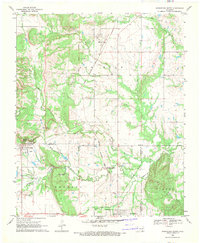
 1963 Ardmore1963 Print · USGSSouthern Oklahoma during the early sixties shows a landscape defined by the Arbuckle Mountains and a booming energy economy. Genealogists and historians can trace family-named sites across the Ardmore Oil Field, find old schools like Southeastern State College, or locate historic markers such as Boggy Depot State Park.2 unique versions available
 - 1966 Map of Tupelo, 1968 Print
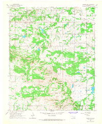
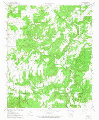
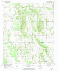
 1966 Tupelo1968 Print · USGSTupelo and central Coal County are captured in the mid-1960s as a vital railroad junction. Researchers can trace the Old Indian Treaty Boundary and locate family burial sites at Byrds Prairie Cem and Wilson Cem.3 unique versions available
 - 1966 Map of Harden City, 1968 Print
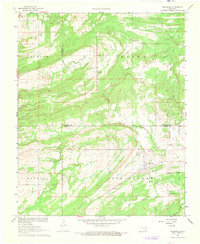
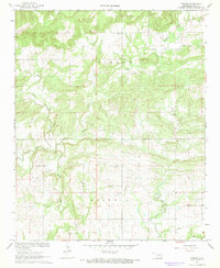
 1966 Harden City1968 Print · USGSOklahoma's oil and cattle country comes to life in the late sixties at the junction of Pontotoc and Coal Counties. Trace the rural landscape through family landmarks like Atkins Cem, the McLish Sch, and industrial sites including a local Refinery.
 - 1967 Map of Wardville, 1968 Print
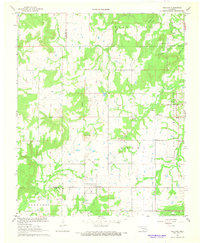
 1967 Wardville1968 Print · USGSWardville and the surrounding prairie lands of Atoka and Coal Counties are captured here in the late sixties, showing a landscape of scattered family farms and energy exploration. Genealogists and local historians can locate King Cem, Lone Star Ch, and the rural community of Wardville near Rabbit Creek.2 unique versions available
 - 1967 Map of Ashland, 1968 Print
 1967 Ashland1968 Print · USGSThe rural landscape of Pittsburg County comes into focus in the late sixties, showing the intersection of local life and military operations. Researchers can trace the Reservation Boundary of the U S Naval Ammunition Depot alongside local landmarks like Friendship Ch and Ward Springs Cem.2 unique versions available
 - 1967 Map of Non, 1968 Print
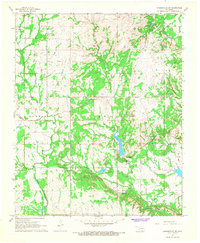
 1967 Non1968 Print · USGSThe rural landscape of Hughes and Coal counties is captured in the late sixties, centered on the settlement of Non. Genealogists and researchers can locate the Non Cemetery, Rock Creek Cemetery, and numerous active sandpits along Boggy Creek.3 unique versions available
 - 1967 Map of Connerville NE, 1968 Print
 1967 Connerville NE1968 Print · USGSJohnston and Coal County show a landscape of remote springs and rural settlements during the late 1960s. Genealogists can trace family sites at Seely Cem and Pilgrim Cem or locate the community hubs of Pontotoc and Bromide.
 - 1967 Map of Parker, 1968 Print
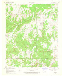
 1967 Parker1968 Print · USGSCentral Oklahoma's rural landscape is captured here in the late 1960s, defined by the winding paths of Muddy Boggy Creek and Salt Creek. Genealogists can locate family landmarks like McCarty Cem or the community hub at Parker and Pine Sch.2 unique versions available
 - 1967 Map of Gerty, 1968 Print
 1967 Gerty1968 Print · USGSThe rural landscape of Hughes and Coal counties is captured here in the late sixties, centered on the town of Gerty. Researchers can locate family landmarks like Gerty Cem and Salt Creek Ch or trace the NE Citra Oil and Gas Field.3 unique versions available
 - 1969 Map of Wapanucka North, 1971 Print
 1969 Wapanucka North1971 Print · USGSOklahoma's Johnston and Coal Counties are captured here in the late sixties, where the Kansas Oklahoma and Gulf Railroad defines the local economy. Researchers can trace the Old Indian Treaty Boundary and locate the Chickasaw Rock Academy (Ruin).2 unique versions available
 - 1969 Map of Olney, 1971 Print
 1969 Olney1971 Print · USGSThe rural landscape of Coal and Atoka Counties is captured here in the late sixties, where small settlements and family plots define the terrain. Genealogists can trace family landmarks like Whitehall Cem and Valley View Cem or the path of the Old Railroad Grade.
End of results
Showing maps 1-11 of 11
Top cities of Coal County
- Coalgate historical maps
- Tupelo historical maps
- Lehigh historical maps
- Phillips historical maps
- Centrahoma historical maps
Frequently asked questions
- What are the different types of historical maps available for Coal County?
- What is the oldest map of Coal County?
- Where can I purchase historical maps of Coal County for my home or office?
- Where can I download high-res historical maps of Coal County?
- Are there historical topographic maps available for Coal County?
- Is there historical aerial imagery available for Coal County?
- Where are historical maps of Coal County sourced from?