1980s Maps of Comanche County, Oklahoma
Explore 7 historic maps of Comanche County from the 1980s. These maps offer a rare glimpse into what life looked like during the 1980s — showing old roads, neighborhoods, homes, and landmarks that have changed or disappeared over time.
Whether you're researching your family's past, planning a metal detecting trip, or studying how Comanche County's landscape evolved across the 1980s, these high-resolution maps are a powerful tool for exploring the history of this region.
- Focus on a specific era: All maps on this page are from the 1980s, giving you a focused view of this time period.
- See what’s changed: Compare century-old streets, trails, and buildings to today's modern landscape using overlays and satellite layers.
- Research with precision: Use these maps for genealogy, historical research, land use analysis, or educational projects.
- View, download, or print: Maps are fully viewable online in high resolution, and can be downloaded or printed for your own records.
Start exploring Comanche County's history through authentic maps from the 1980s. This is your window into the past.
Comanche County, OK maps
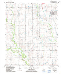
(7)- 1981 Map of Lawton
 1981 Lawton1981 Print · USGSSouthwestern Oklahoma in the early eighties shows a landscape shaped by military history and the rising peaks of the Wichitas. Researchers can trace the boundaries of the Fort Sill Military Reservation and locate early settlements like Meers, Chattanooga, and Richards Spur.
 - 1985 Map of Burkburnett, 1986 Print
 1985 Burkburnett1986 Print · USGSThe Red River valley and North Texas oil fields are captured here in the mid-eighties, showing the vital connection between military hubs and rail towns. Researchers can trace the path of the Missouri Kansas Texas railroad through Burkburnett or locate Waurika Lake and Sheppard Air Force Base.2 unique versions available
 - 1987 Map of Faxon
 1987 Faxon1987 Print · USGSSouthwestern Oklahoma near the Comanche and Cotton county line is captured in the late eighties as a quiet agricultural landscape. Genealogists can locate Faxon Cem and trace rural property lines near Faxon and the West Cache Creek drainage.
 - 1987 Map of Walters NE
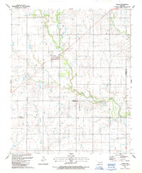
 1987 Walters NE1987 Print · USGSCotton and Comanche Counties in the late 1980s reveal a landscape defined by petroleum extraction and creek-side settlements. Genealogists and historians can locate Allendale Cem, New Salem Ch, and the streets of Geronimo amidst a network of Oil Wells.
 - 1987 Map of Geronimo
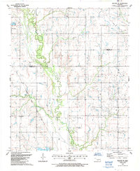
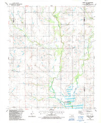
 1987 Geronimo1987 Print · USGSGeronimo and the surrounding Comanche County townships are captured in the late 1980s as the regional rail and turnpike networks integrated with the rural landscape. Researchers can trace the path of the Oklahoma Kansas and Texas railroad and locate the Elm Grove Cem or the small settlement of Crosby.
 - 1987 Map of Chattanooga
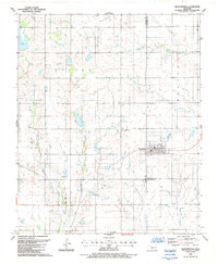 1987 Chattanooga1987 Print · USGSThe rural prairie of Comanche and Tillman counties is captured here in the late 1980s. Researchers can locate the Chattanooga Cem and trace water-dependent landmarks like Kinder Lake or the numerous Gravel Pits dotting the landscape.
 - 1987 Map of Temple NW, 1988 Print
 1987 Temple NW1988 Print · USGSCotton County during the late 1980s reveals a rural landscape deeply integrated with the petroleum industry. Genealogists and local historians can locate Comanche Cem, trace the course of Beaver Creek, and identify small communities like Hulen.
End of results
Showing maps 1-7 of 7
Top cities of Comanche County
- Lawton historical maps
- Cache historical maps
- Elgin historical maps
- Geronimo historical maps
- Fletcher historical maps
- Sterling historical maps
See more
Frequently asked questions
- What are the different types of historical maps available for Comanche County?
- What is the oldest map of Comanche County?
- Where can I purchase historical maps of Comanche County for my home or office?
- Where can I download high-res historical maps of Comanche County?
- Are there historical topographic maps available for Comanche County?
- Is there historical aerial imagery available for Comanche County?
- Where are historical maps of Comanche County sourced from?