Old Maps of Comanche County, Oklahoma for Genealogy
Trace your family roots with 200 historic maps of Comanche County. These high-res maps reveal old neighborhoods, homesites, landmarks, and streets — helping you uncover where your ancestors lived and how the area evolved over time.
- Explore historic neighborhoods: Identify where your relatives may have lived in the 1800s or 1900s.
- Compare maps over time: Trace the changes in streets, buildings, and landmarks for multi-generational research.
- Perfect for genealogy & ancestry research: Used by family historians and researchers to map out lineage and migration.
These maps are an incredible resource for exploring your personal connection to Comanche County's past.
Comanche County, OK maps
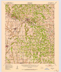
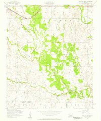
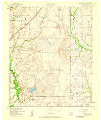
(200)- 1937 Map of Cache
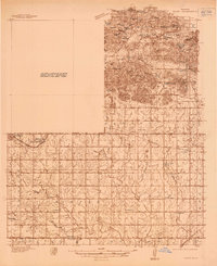 1937 Cache1937 Print · USGSComanche County reveals its dual nature in the late thirties, split between the high peaks of the Wichita Mountains and the rural farmsteads to the south. Genealogists and historians can locate vanished landmarks like Quilla Sch, Deyo Sch, and the Cache Cem during the height of the local rail-and-ranch economy.
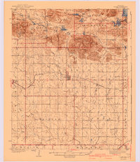
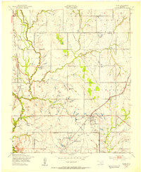
 - 1937 Map of Quanah Mountain
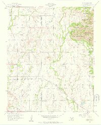
 1937 Quanah Mountain1937 Print · USGSComanche County during the late 1930s shows a landscape of conservation and transition between the Wichita Mountains and the plains. Researchers can locate New Deal-era infrastructure at C C C Camp No 870 and cultural sites like Post Oak Mission.
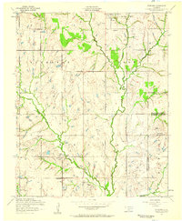
 - 1942 Map of Cache
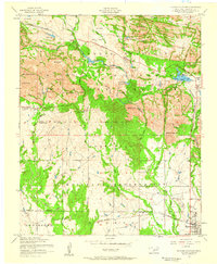
 1942 Cache1942 Print · USGSComanche County during the late 1930s reveals a unique landscape where the Wichita Mountains Wildlife Refuge meets the rail-side towns of the plains. Genealogists can trace rural life through sites like Post Oak Mission, Devo Memorial Chapel, and the Spring Valley Sch.3 unique versions available
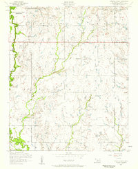
 - 1946 Map of Lawton
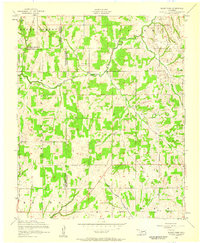
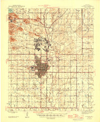 1946 Lawton1946 Print · USGSOklahoma’s military and agricultural heritage is on full display in the mid-1940s as the city of Lawton expands south of Fort Sill. Researchers can trace rural school districts like Flower Mound Sch or locate landmarks such as the Cameron State Agricultural College.2 unique versions available
 - 1949 Map of Mount Scott, 1952 Print
 1949 Mount Scott1952 Print · USGSThe Wichita Mountains meet the Fort Sill Military Reservation in the late 1940s, showing a landscape of granite peaks and new reservoirs. Genealogists and historians can locate Medicine Park, the Spring Valley Sch, and the Easter Pageant grounds.2 unique versions available
 - 1949 Map of Arbuckle Hill, 1953 Print
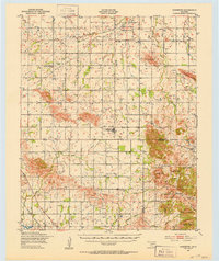
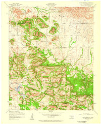
 1949 Arbuckle Hill1953 Print · USGSComanche County is shown in the late 1940s as a landscape defined by the expansive Fort Sill grounds and Indigenous heritage. Researchers can trace land use through landmarks like the Indian School, Indian Cem, and the St Louis San Francisco rail line.2 unique versions available
 - 1949 Map of Cooperton, 1953 Print
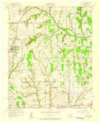
 1949 Cooperton1953 Print · USGSKiowa and Comanche counties at the close of the 1940s reveal a landscape defined by the Rainy Mountain Indian School Reservation and the rising Wichita Mountains. Genealogists and researchers can trace rural life through the Gold Mine (Abandoned), Union Dale Cem, and the village of Cooperton.2 unique versions available
 - 1949 Map of Cement, 1953 Print
 1949 Cement1953 Print · USGSThe oil-and-rail economy of Caddo and Comanche counties is on full display here in the late forties. Researchers can locate dozens of country schools like Highview Sch and Rocky Ford Sch or trace the industrial footprint of the Oil Refinery at Cyril.
 - 1949 Map of Elgin, 1953 Print
 1949 Elgin1953 Print · USGSElgin and the surrounding Comanche County prairie are documented here just after the war as the region's rail and military presence defined local growth. Researchers can locate family landmarks such as St Anthonys Ch, Elgin Cem, and rural schools like Happy Hollow Sch.2 unique versions available
 - 1949 Map of Quanah Mountain, 1953 Print
 1949 Quanah Mountain1953 Print · USGSComanche County reveals a complex landscape of wildlife preservation and Comanche heritage just after the war. You can trace the locations of the Old Star House, Post Oak Mission, and Quanah Parker Camp alongside the granite peaks of Elk Mountain and Quanah Mountain.2 unique versions available
 - 1949 Map of Fort Sill, 1953 Print
 1949 Fort Sill1953 Print · USGSComanche County reveals its dual identity as a military hub and a growing prairie city in the years following World War II. Researchers can trace the boundaries of the Fort Sill reservation, locate the Fort Sill Indian School, and find local landmarks like Medicine Park or the Highland Cemetery.2 unique versions available
 - 1949 Map of Nellie, 1953 Print
 1949 Nellie1953 Print · USGSThe Oklahoma plains around the Comanche and Stephens county lines come alive in this post-war survey. Researchers can trace the social fabric of rural life through numerous country schools and churches, including Starr Sch, Nellie, and the Rock Creek Cem.2 unique versions available
 - 1950 Map of Snyder, 1953 Print
 1950 Snyder1953 Print · USGSKiowa and Tillman Counties come into focus during the early fifties, showing a landscape where the granite peaks of the Wichita Mountains meet the Oklahoma prairie. Genealogists can locate numerous rural landmarks like Richland Sch, Maple Grove Ch, and the Oklahoma Cem.2 unique versions available
 - 1950 Map of Saddle Mountain, 1953 Print
 1950 Saddle Mountain1953 Print · USGSSouthwestern Oklahoma in the early fifties shows a landscape where high granite peaks meet missionary history and early wildlife conservation. Researchers can trace rural school locations like Dixie Sch or find the remote Saddle Mountain Indian Mission and Kiowa Mission tucked among the foothills.2 unique versions available
 - 1955 Map of Lawton, 1958 Print
 1955 Lawton1958 Print · USGSSouthwestern Oklahoma and North Texas are shown here in the mid-fifties, dominated by the Wichita Mountains and the vital Red River watershed. Genealogists and historians can trace the foundations of Lawton alongside rural landmarks like Rainy Mountain Church and Pleasant Hill School.5 unique versions available
 - 1956 Map of Sterling, 1959 Print
 1956 Sterling1959 Print · USGSMid-century Comanche County is shown here as an active landscape of petroleum production and rural community life. Researchers can trace family roots through the Sterling Cemetery and Denton Cemetery or locate old industrial sites near Coxs Corner and the Oil Field.2 unique versions available
 - 1956 Map of Ninemile Creek, 1959 Print
 1956 Ninemile Creek1959 Print · USGSComanche County was transitioning into an energy-rich landscape in the mid-fifties as oil production expanded near the Ninemile Creek drainage. Genealogists and historians can locate rural landmarks like Mineral Wells School, Roseland School, and the Fort Sill Indian School Reservation.3 unique versions available
 - 1956 Map of Post Oak Creek, 1959 Print
 1956 Post Oak Creek1959 Print · USGSSouthwestern Oklahoma's agricultural and mission history comes into focus in the mid-1950s near the Comanche and Tillman county line. Researchers can trace the St Louis - San Francisco rail corridor and find the Nazarene (Indian) Mission near Indiahoma.2 unique versions available
 - 1956 Map of Saddle Mountain, 1959 Print
 1956 Saddle Mountain1959 Print · USGSThe Wichita Mountains in the mid-1950s are presented here in high detail at the junction of Kiowa and Comanche counties. Genealogists and researchers can locate the Saddle Mountain Indian Mission or trace the rugged Geronimo Ridge near Comanche Lake.3 unique versions available
 - 1956 Map of Fletcher, 1959 Print
 1956 Fletcher1959 Print · USGSMid-century Oklahoma comes alive here as the St Louis San Francisco railroad passes through Fletcher. Researchers can find family landmarks like the Little Washita Indian Church, Mount View, and the Washita Indian Cemetery.2 unique versions available
 - 1956 Map of Cooperton, 1959 Print
 1956 Cooperton1959 Print · USGSThe Oklahoma plains meet the Wichita Mountains in the mid-1950s, showing a landscape of isolated peaks and rural church communities. Researchers can trace local history at Springhill Cemetery or explore landmarks like Cut Throat Lake and Baker Peak.2 unique versions available
 - 1956 Map of Arbuckle Hill, 1959 Print
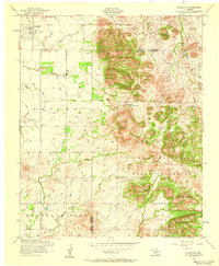
 1956 Arbuckle Hill1959 Print · USGSMid-century Comanche County is shown here during a period of heavy military and industrial activity. Genealogists and researchers can locate the Fort Sill Indian School, the Indian Cemetery, and oil operations near Zella.4 unique versions available
 - 1956 Map of Odetta, 1959 Print
 1956 Odetta1959 Print · USGSThe granite peaks of the Wichita Mountains met the Oklahoma plains in the mid-1950s, creating a varied landscape of wildlife habitat and military grounds. Researchers can trace the St Louis San Francisco railroad line through Odetta or locate landmarks like Cottonwood Spring and Sunset Peak.3 unique versions available
 - 1956 Map of Quanah Mountain, 1959 Print
 1956 Quanah Mountain1959 Print · USGSThe Wichita Mountains in the mid-fifties reveal a landscape of military training grounds and wildlife conservation just north of the rail lines. Trace the development of Indiahoma and Cache, find the curious Official Dog Town, and locate family sites near Quanah Parker Lake.4 unique versions available
 - 1956 Map of Rocky Ford, 1959 Print
 1956 Rocky Ford1959 Print · USGSThe rural borders of Grady, Caddo, and Comanche Counties come into focus during the mid-fifties. Researchers can trace ancestral locations near the Washita River or find local landmarks like Cedar Grove Church, Ridley Cemetery, and the settlement of Rocky Ford.2 unique versions available
Showing maps 1-25 of 200
Top cities of Comanche County
- Lawton historical maps
- Cache historical maps
- Elgin historical maps
- Geronimo historical maps
- Fletcher historical maps
- Sterling historical maps
See more
Frequently asked questions
- What are the different types of historical maps available for Comanche County?
- What is the oldest map of Comanche County?
- Where can I purchase historical maps of Comanche County for my home or office?
- Where can I download high-res historical maps of Comanche County?
- Are there historical topographic maps available for Comanche County?
- Is there historical aerial imagery available for Comanche County?
- Where are historical maps of Comanche County sourced from?