
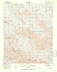
1950 Map of Saddle Mountain
USGS Topo · Published 1953About this map
Wichita Mountains Wildlife Refuge dominates the southern half of this landscape, encompassing a complex series of peaks and ridges including Mount Scott, Mount Sheridan, and Geronimo Ridge. This 1950s record documents the cultural footprint of the Kiowa, Caddo, and Comanche borderlands, highlighted by several religious outposts such as the Saddle Mountain Indian Mission, Cache Indian Mission, and Kiowa Mission. Settlement patterns are concentrated around the small village of Meers and the rural community at Alden, where Alden Sch and Alden Cem serve the local population. The map captures the rugged transition from the high peaks like Saddle Mountain and Zodletone Mountain down to the plains, where the Fort Sill Military Reservation begins its reach. Water management for the region is anchored by Lake Lawtonka in the southeast corner, fed by drainages like Medicine Creek.
Find a feature on this map
72 named features on this map. Tap any name to fly to it.
Don’t see what you’re looking for? This feature index may not catch every label — zoom into the map to look around manually.
Map Details
Editions of this 1950 Saddle Mountain Map
2 editions found
Other maps of this area

1937 · Cache
USGS Topo · 1:48,000

1937 · Quanah Mountain
USGS Topo · 1:24,000

1942 · Cache
USGS Topo · 1:62,500

1946 · Lawton
USGS Topo · 1:62,500

1949 · Mount Scott
USGS Topo · 1:24,000

1949 · Cooperton
USGS Topo · 1:62,500

1949 · Quanah Mountain
USGS Topo · 1:24,000

1949 · Fort Sill
USGS Topo · 1:24,000

1950 · Snyder
USGS Topo · 1:62,500

1951 · Fort Cobb
USGS Topo · 1:62,500