1960s Maps of Ponca City, Oklahoma
Explore 5 historic maps of Ponca City from the 1960s. These maps offer a rare glimpse into what life looked like during the 1960s — showing old roads, neighborhoods, homes, and landmarks that have changed or disappeared over time.
Whether you're researching your family's past, planning a metal detecting trip, or studying how Ponca City's landscape evolved across the 1960s, these high-resolution maps are a powerful tool for exploring the history of this region.
- Focus on a specific era: All maps on this page are from the 1960s, giving you a focused view of this time period.
- See what’s changed: Compare century-old streets, trails, and buildings to today's modern landscape using overlays and satellite layers.
- Research with precision: Use these maps for genealogy, historical research, land use analysis, or educational projects.
- View, download, or print: Maps are fully viewable online in high resolution, and can be downloaded or printed for your own records.
Start exploring Ponca City's history through authentic maps from the 1960s. This is your window into the past.
Ponca City, OK maps
(5)- 1963 Map of Charley Creek, 1964 Print
 1963 Charley Creek1964 Print · USGSThe Arkansas River defines the border of Kay and Osage counties in the early 1960s, a landscape shaped by petroleum and rural community life. Researchers can trace family roots at Longwood Ch, Braden Sch, and the Big Bend Oil Field.4 unique versions available
 - 1963 Map of Uncas, 1965 Print
 1963 Uncas1965 Print · USGSThe Arkansas River valley in Kay County shows a landscape of rail-served settlements and early energy production in the early sixties. Trace the path of the Atchison Topeka and Santa Fe through Uncas and locate historical Oil Wells and the Oak Grove Cem.2 unique versions available
 - 1968 Map of Ponca City NW, 1969 Print
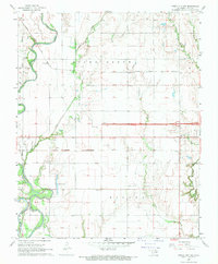 1968 Ponca City NW1969 Print · USGSThe Kay County landscape during the late sixties is defined by a heavy rail presence and burgeoning oil production near the Arkansas River. Genealogists and historians can trace the foundations of rural Oklahoma through sites like Autwine, Union Sch, and the Round Grove Cem.2 unique versions available
 - 1968 Map of Kildare, 1970 Print
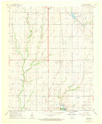 1968 Kildare1970 Print · USGSKay County in the late sixties reveals a landscape shaped by petroleum production and the rail corridor. Researchers can trace the Northwest Kildare Oil and Gas Field and locate landmarks like Pleasant View Sch and Wolf Creek Cem.2 unique versions available
 - 1968 Map of Ponca City, 1970 Print
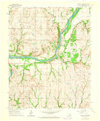
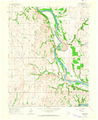
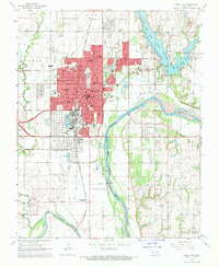 1968 Ponca City1970 Print · USGSPonca City and the surrounding Kay County prairies are captured here in the late sixties, highlighting a landscape shaped by petroleum and the Arkansas River. Researchers can locate family sites at St Marys Cem, trace the Atchison Topeka and Santa Fe rail lines, or find the White Eagle Station.2 unique versions available
End of results
Showing maps 1-5 of 5
Top cities near Ponca City
- Blackwell historical maps
- Tonkawa historical maps
- Newkirk historical maps
- Kaw City historical maps
- Marland historical maps
- Kildare historical maps
Frequently asked questions
- What are the different types of historical maps available for Ponca City?
- What is the oldest map of Ponca City?
- Where can I purchase historical maps of Ponca City for my home or office?
- Where can I download high-res historical maps of Ponca City?
- Are there historical topographic maps available for Ponca City?
- Is there historical aerial imagery available for Ponca City?
- Where are historical maps of Ponca City sourced from?