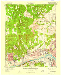
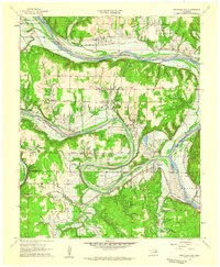
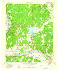
Old Maps of Osage County, Oklahoma for Metal Detecting
Plan your next treasure hunt with 320 historic maps of Osage County. Find old homesites, ghost towns, trails, and gathering spots that may be lost to time — perfect for identifying promising metal detecting locations.
- Locate forgotten sites: Uncover places like long-lost settlements, abandoned rail lines, or gathering spots.
- Plan better hunts: Use map overlays combined with LiDAR or satellite views to narrow in on historically rich areas.
- Made for detectorists: Thousands of hobbyists use these maps to discover relics, coins, and hidden history.
Use these historic maps to boost your research and find new opportunities beneath the surface of Osage County.
Osage County, OK maps
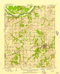
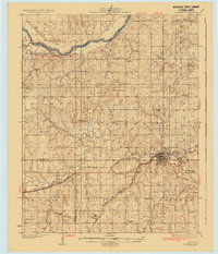
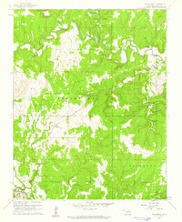
(320)- 1906 Map of Nelagoney, 1975 Print
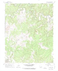 1906 Nelagoney1975 Print · USGSOsage County is captured here during a mid-century era of petroleum production and rail transit. Researchers can trace the routes of the Missouri Kansas Texas railroad and locate small stops like Okesa, Kiheki, and the Boy Scout Camp.
 - 1909 Map of Pawhuska, 1957 Print
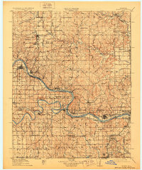
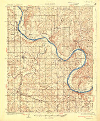
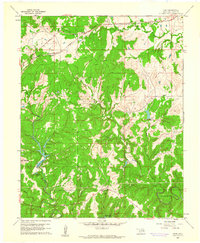
 1909 Pawhuska1957 Print · USGSOsage County comes alive in this turn-of-the-century survey of the terrain around Pawhuska and its neighboring rail towns. Trace the paths of three major railroads as they pass through Barnsdall, find landmarks like Daltons Caves, or locate the White Swan Ford.
 - 1910 Map of Pawhuska
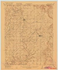
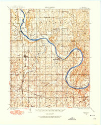
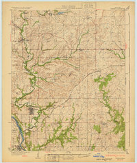
 1910 Pawhuska1910 Print · USGSOsage County's landscape at the dawn of Oklahoma statehood reveals a transition from tribal lands to a rail-connected economy. Genealogists and historians can trace early settlements like Wynona and Bigheart, or find local landmarks like Daltons Caves and White Swan Ford.2 unique versions available
 - 1912 Map of Hominy, 1960 Print
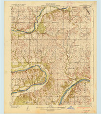
 1912 Hominy1960 Print · USGSNortheastern Oklahoma comes alive in this pre-reservoir survey, documenting the river-valley settlements and tribal lands of the early statehood era. Genealogists can locate dozens of country schools and sites like Black Dog (Indian Village) or the early Oil City Barnsdall P O.
 - 1915 Map of Hominy
 1915 Hominy1915 Print · USGSOsage and Creek counties come to life in the years before the Great War, showing a landscape defined by river confluences and the expansion of the rail industry. Genealogists can locate early settlements like Black Dog and schools like Dripping Spring School or Sunset School.2 unique versions available
 - 1915 Map of Hominy, 1928 Print
 1915 Hominy1928 Print · USGSNortheast Oklahoma during the early oil and rail boom is captured here as the Osage and Creek county lines meet the great river bends. Genealogists can trace early homesteads near Black Dog, Oil City, and Union Chapel.2 unique versions available
 - 1916 Map of Foraker
 1916 Foraker1916 Print · USGSNorthern Osage County is captured here just before the First World War, showing the ranching and rail landscape of the Oklahoma-Kansas border. Family historians can locate rural landmarks like Red Eagle School, Grainola, and the Midland Valley railroad.2 unique versions available
 - 1929 Map of Skedee, 1975 Print
 1929 Skedee1975 Print · USGSNorth-central Oklahoma's river-and-rail landscape is captured here in the late 1920s, dominated by the looping current of the Arkansas River. Genealogists and historians can trace numerous rural schools and early infrastructure, from the East Bend Ferry to the Bug Creek Indian Camp.
 - 1930 Map of Pawnee, 1958 Print
 1930 Pawnee1958 Print · USGSNorth-central Oklahoma at the start of the 1930s shows a landscape shaped by river commerce, the oil industry, and early rail lines. Local historians can trace the Pawnee Indian School Reservation, the Old Town Trading Post, and numerous rural school sites like Highland Sch.
 - 1931 Map of Skedee
 1931 Skedee1931 Print · USGSPawnee and Osage counties are shown here during the late 1920s, when river crossings and rural schools defined the community landscape. Genealogists can locate family landmarks like the Bug Creek Indian Camp, Mt Pleasant Cemetery, and the East Bend Ferry.3 unique versions available
 - 1932 Map of Fairfax
 1932 Fairfax1932 Print · USGSOsage County is shown at the height of its oil-era development in the early thirties. Local historians can trace the industrial footprint of Carter Nine, find rural landmarks like St Johns Sch, and follow the Atchison Topeka and Santa Fe rail line.4 unique versions available
 - 1935 Map of Kaw
 1935 Kaw1935 Print · USGSNorthern Oklahoma's river valleys and rural school districts are captured here in the mid-1930s as the Santa Fe railroad shaped the local economy. Researchers can trace vanished rural hubs and landmarks like Chilocco, Maple Grove Ch, and Uncas.2 unique versions available
 - 1936 Map of Belford
 1936 Belford1936 Print · USGSOsage and Noble counties come into focus in the mid-1930s, showing a rural landscape defined by the winding Arkansas River. Genealogists and local historians can trace numerous country school sites like Braden Sch and Pleasant Valley Sch, alongside the Atchison Topeka and Santa Fe Ry through Apperson.3 unique versions available
 - 1936 Map of Pawnee
 1936 Pawnee1936 Print · USGSPawnee County and the surrounding cattle and oil country come alive in this mid-thirties survey of the Oklahoma plains. Researchers can locate dozens of country schools like Star A Star Sch and trace the Pawnee Indian School Reservation and the Old Town Trading Post.2 unique versions available
 - 1955 Map of Enid, 1966 Print
 1955 Enid1966 Print · USGSNorth-central Oklahoma's transition from open plains to the blackjack hills of the Osage Indian Reservation is captured in the mid-1950s. Researchers can trace the development of the Naval Reserve Oil Field, the grounds of Vance AFB, and the early footprints of Tulsa and Stillwater.4 unique versions available
 - 1956 Map of Sand Springs, 1957 Print
 1956 Sand Springs1957 Print · USGSThe industrial corridor along the Arkansas River comes to life in this mid-century survey of the Tulsa and Sand Springs area. Researchers can trace the extensive Oil Field networks, the massive Oil Refinery, and dozens of local landmarks like Woodland Cemetery and the Tulsa North Airport.6 unique versions available
 - 1958 Map of Enid
 1958 Enid1958 Print · USGSNorthern Oklahoma is mapped here in the late fifties, showcasing a dense network of petroleum production and historic tribal lands. Researchers can trace the legacy of the Osage Indian Reservation, early energy hubs like the Cushing Oil Field, and the Chilocco Indian Agricultural School.2 unique versions available
 - 1958 Map of Keystone Dam, 1959 Print
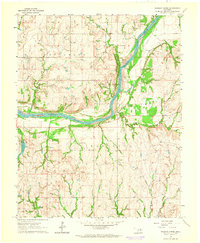
 1958 Keystone Dam1959 Print · USGSOklahoma's river valleys underwent a massive transformation in the late fifties as the Keystone Dam Under Construction project began. Researchers can trace the original locations of Prue, Appalachia, and Keystone along with family-named sites like Dixie Cem.4 unique versions available
 - 1958 Map of Wekiwa, 1959 Print
 1958 Wekiwa1959 Print · USGSThe Arkansas River valley of the late 1950s was a landscape defined by the Osage Indian Reservation, heavy oil production, and vital rail lines. Genealogists and local historians can trace the foundations of Fisher and Wekiwa, along with rural landmarks like Anderson Sch and Fisher Ch.5 unique versions available
 - 1960 Map of Nanos, 1961 Print
 1960 Nanos1961 Print · USGSOsage County in the early sixties is shown here as a landscape of rural industry and rail transport. Genealogists and historians can locate the Pappin Cem and trace the paths of Wild Hog Creek or the Atchison Topeka and Santa Fe line.2 unique versions available
 - 1960 Map of Nelagoney, 1961 Print
 1960 Nelagoney1961 Print · USGSThe Osage Hills at the start of the sixties were a landscape defined by petroleum production and quiet creek valleys. Local historians can trace the paths of the Missouri Kansas Texas railroad through Okesa and identify oil wells across Strike Axe.2 unique versions available
 - 1960 Map of Herd, 1961 Print
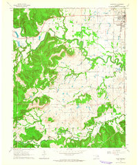
 1960 Herd1961 Print · USGSOsage County's industrial and recreational landscape is captured here in the early sixties as petroleum extraction and state park development shaped the hills. Genealogists and historians can trace the Atchison Topeka and Santa Fe rail line through Herd and Bigheart, and locate rural landmarks like Twin Mounds or the old Cem.4 unique versions available
 - 1960 Map of Pawhuska, 1961 Print
 1960 Pawhuska1961 Print · USGSThe Osage County seat comes alive in the early sixties, showing a community built on a foundation of oil and ranching. Genealogists and historians can trace rail lines like the Midland Valley or locate local landmarks including Indian Camp Sch and Lookout Cem.3 unique versions available
 - 1963 Map of Charley Creek, 1964 Print
 1963 Charley Creek1964 Print · USGSThe Arkansas River defines the border of Kay and Osage counties in the early 1960s, a landscape shaped by petroleum and rural community life. Researchers can trace family roots at Longwood Ch, Braden Sch, and the Big Bend Oil Field.4 unique versions available
 - 1963 Map of Avant SE, 1964 Print
 1963 Avant SE1964 Print · USGSOsage and Tulsa counties meet here in the early sixties, as the oil industry and railroads shaped the local landscape. Genealogists can trace family footprints at Captain Cem, Delaware Ch, and the outlying Osage Gardens development.4 unique versions available
Showing maps 1-25 of 320
Top cities of Osage County
- Pawhuska historical maps
- Hominy historical maps
- Fairfax historical maps
- Barnsdall historical maps
- Wynona historical maps
- Shidler historical maps
See more
Frequently asked questions
- What are the different types of historical maps available for Osage County?
- What is the oldest map of Osage County?
- Where can I purchase historical maps of Osage County for my home or office?
- Where can I download high-res historical maps of Osage County?
- Are there historical topographic maps available for Osage County?
- Is there historical aerial imagery available for Osage County?
- Where are historical maps of Osage County sourced from?