1970s Maps of Osage County, Oklahoma
Explore 24 historic maps of Osage County from the 1970s. These maps offer a rare glimpse into what life looked like during the 1970s — showing old roads, neighborhoods, homes, and landmarks that have changed or disappeared over time.
Whether you're researching your family's past, planning a metal detecting trip, or studying how Osage County's landscape evolved across the 1970s, these high-resolution maps are a powerful tool for exploring the history of this region.
- Focus on a specific era: All maps on this page are from the 1970s, giving you a focused view of this time period.
- See what’s changed: Compare century-old streets, trails, and buildings to today's modern landscape using overlays and satellite layers.
- Research with precision: Use these maps for genealogy, historical research, land use analysis, or educational projects.
- View, download, or print: Maps are fully viewable online in high resolution, and can be downloaded or printed for your own records.
Start exploring Osage County's history through authentic maps from the 1970s. This is your window into the past.
Osage County, OK maps
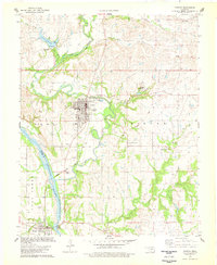
(24)- 1971 Map of Bowring, 1973 Print
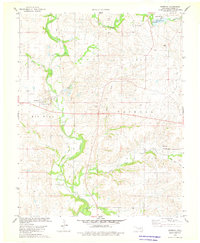
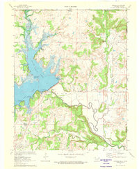 1971 Bowring1973 Print · USGSOsage County's landscape in the early seventies centers on the newly established Hulah Lake and the shifting economy of northern Oklahoma. Genealogists and local historians can trace family-named sites and infrastructure near Bowring, the Old Railroad Grade, and Deadmans Rock.
 - 1971 Map of Woolaroc, 1973 Print
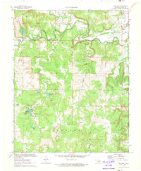 1971 Woolaroc1973 Print · USGSOsage County in the early seventies shows a landscape where high-culture estates and heavy industry meet. Genealogists and historians can locate the Woolaroc Museum, trace the Missouri-Kansas-Texas rail line, and find local landmarks like Osage Hills Sch.2 unique versions available
 - 1971 Map of Bowring SE, 1973 Print
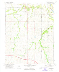
 1971 Bowring SE1973 Print · USGSOsage and Washington counties in the early 1970s showcase a transition between petroleum production and growing recreational development. Genealogists and historians can trace the industrial footprint of Caney Field and local social life at the Sunset Country Club.
 - 1972 Map of Wolco, 1973 Print
 1972 Wolco1973 Print · USGSOsage County in the early seventies is mapped here as an active petroleum landscape centered on Wolco. Genealogists and historians can trace old property lines and industrial sites, from the banks of Lake Waxhoma to family plots at the Cem near Candy Creek.
 - 1972 Map of Morrison NE, 1974 Print
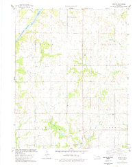
 1972 Morrison NE1974 Print · USGSThe Otoe-Missouria tribal lands of Noble County are captured in the early 1970s just as the modern turnpike was being built. Trace local heritage at the Otoe-Missouria Indian Agency, the Otoe-Missouria Cem, and landmarks like Big Hill.3 unique versions available
 - 1973 Map of Happy Hollow, 1975 Print
 1973 Happy Hollow1975 Print · USGSThe Osage Indian Reservation in the early seventies shows a landscape where industrial oil production meets a network of rugged creeks. Researchers can locate remote sites like a lone Grave or trace the paths of Little Hominy Creek and Happy Hollow.
 - 1973 Map of Pearsonia, 1975 Print
 1973 Pearsonia1975 Print · USGSThe Osage Indian Reservation in the early 1970s reveals a landscape defined by ranching and energy production. Genealogists and historians can trace the footprint of Pearsonia and Blackland, or follow the path of the Old RR Grade and numerous oil wells.
 - 1973 Map of Pearsonia NE, 1975 Print
 1973 Pearsonia NE1975 Print · USGSOsage County and the Oklahoma-Kansas border are captured in the early 1970s as the regional petroleum economy shaped the valley. Trace the industrial footprint of the Oil Field and Oil Wells surrounding Hulah Lake and the Caney River.
 - 1973 Map of Bluestem Lake, 1975 Print
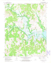
 1973 Bluestem Lake1975 Print · USGSOsage County's interior reveals a landscape of industrial development and reservoir construction in the mid-1970s. Local researchers can trace the path of an Old Railroad Grade or locate historic sites like the Cem and Pawhuska Municipal Airport.2 unique versions available
 - 1973 Map of Foraker North, 1975 Print
 1973 Foraker North1975 Print · USGSOsage County ranching and oil lands appear here in the early seventies as they span the Kansas-Oklahoma state line. Researchers can trace family roots at St Johns Cem or locate historical infrastructure like the Adams Ranch Airport and the Foraker Field.
 - 1973 Map of Whippoorwill, 1975 Print
 1973 Whippoorwill1975 Print · USGSThe Osage Indian Reservation and the Kansas-Oklahoma border met along the Caney River in the early seventies as the landscape transitioned toward reservoir recreation. Researchers can trace the layout of Boulangerville, locate the Hulah Lake State Waterfowl Refuge, and find legacy landmarks like Boulanger Landing.
 - 1973 Map of Pearsonia NW, 1975 Print
 1973 Pearsonia NW1975 Print · USGSThe Osage Hills along the Oklahoma-Kansas border are captured in the early 1970s, showing a landscape defined by ranching and oil production. Genealogists and historians can trace the Indian Oklahoma Reservation Boundary and locate scattered Oil Wells along the Caney River.
 - 1973 Map of Foraker South, 1975 Print
 1973 Foraker South1975 Print · USGSOsage County ranching and the petroleum industry define this prairie landscape in the early seventies. Genealogists and historians can trace family roots at Foraker Cem or locate the Codding Cattle Research Airport near the historic Old Railroad Grade.
 - 1978 Map of Prettyhair Creek
 1978 Prettyhair Creek1978 Print · USGSThe Arkansas River valley at the Osage and Noble county line appears in the late 1970s as a land of ranching and oil exploration. Researchers can trace family history through landmarks like Bressie Cem, Pixley Cem, and the Bar L Ranch.
 - 1978 Map of Burbank
 1978 Burbank1978 Print · USGSBurbank and the Osage County oil patches are shown here in the late seventies as a landscape of energy extraction and small-town resilience. Researchers can trace the Old Railroad Grade, locate the Burbank Cem, and explore the limits of the Chief Oil Field.
 - 1978 Map of Lucy Creek
 1978 Lucy Creek1978 Print · USGSOsage Indian Reservation territory in the late seventies is shown here during a peak of petroleum production and rural land management. Researchers can locate active Oil Field infrastructure and trace watercourses like Hominy Creek and Gray Horse Creek.
 - 1978 Map of Doga Creek
 1978 Doga Creek1978 Print · USGSOsage and Pawnee counties meet along the Arkansas River in the late seventies, where the energy industry and tribal lands intersect. Researchers can trace family history at Drake Cem or map the industrial landscape of the Oil Field and Coal Creek.
 - 1978 Map of Masham
 1978 Masham1978 Print · USGSNorthern Oklahoma in the late seventies is shown as a landscape of energy and agriculture along the Arkansas River. Researchers can trace old family sites at Masham Cem or locate early petroleum infrastructure at the Oil Field near Skedee.
 - 1978 Map of Baconrind Creek
 1978 Baconrind Creek1978 Print · USGSOsage Indian Reservation land is shown here in the late 1970s, characterized by its deep ties to the petroleum industry. Researchers can trace the layout of the Fairfield Oil Field and locate landmarks like the T-Apple Ranch and Baconrind Creek.
 - 1978 Map of Skedee
 1978 Skedee1978 Print · USGSOklahoma's river borderlands in the late seventies show the intersection of the Osage Indian Reservation and the Pawnee county line. Genealogists can locate family burial sites at Riverside Cem and Wheeler Cem or trace the Atchison Topeka and Santa Fe rail line through Skedee.
 - 1978 Map of Watchorn
 1978 Watchorn1978 Print · USGSThe Arkansas River corridor in the late seventies reveals a landscape shaped by petroleum extraction and tribal boundaries. Genealogists and researchers can locate the settlement of Watchorn and trace the complex network of an Oil Field, Oil Wells, and a regional Pipeline.
 - 1978 Map of Bug Creek
 1978 Bug Creek1978 Print · USGSThe Arkansas River valley in the late 1970s shows a landscape transitioning between rural prairie and active petroleum production. Genealogists can locate Whitehorn Cem and Morrel Cem alongside the winding Bug Creek and Sycamore Creek.
 - 1978 Map of Fairfax
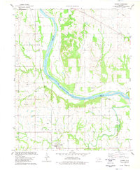
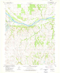
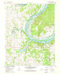
 1978 Fairfax1978 Print · USGSOsage County's ranching and oil landscape is captured in the late seventies as the town of Fairfax thrives alongside the Arkansas River. Genealogists can locate Fairfax Cem and Gray Horse Cem while tracing the Atchison Topeka and Santa Fe Railroad.
 - 1978 Map of Blackburn
 1978 Blackburn1978 Print · USGSThe Arkansas River curves through Pawnee and Osage counties in the late seventies, following the historic Osage Indian Reservation Boundary. Genealogists and historians can locate the Blackburn Cem, the Will Rogers Camp, and the industrial tracks of the St Louis - San Francisco railroad.2 unique versions available
End of results
Showing maps 1-24 of 24
Top cities of Osage County
- Pawhuska historical maps
- Hominy historical maps
- Fairfax historical maps
- Barnsdall historical maps
- Wynona historical maps
- Shidler historical maps
See more
Frequently asked questions
- What are the different types of historical maps available for Osage County?
- What is the oldest map of Osage County?
- Where can I purchase historical maps of Osage County for my home or office?
- Where can I download high-res historical maps of Osage County?
- Are there historical topographic maps available for Osage County?
- Is there historical aerial imagery available for Osage County?
- Where are historical maps of Osage County sourced from?