1900-1909 Maps of Osage County, Oklahoma
Explore 2 historic maps of Osage County from 1900-1909. These maps offer a rare glimpse into what life looked like during the 1900s — showing old roads, neighborhoods, homes, and landmarks that have changed or disappeared over time.
Whether you're researching your family's past, planning a metal detecting trip, or studying how Osage County's landscape evolved across the 1900s, these high-resolution maps are a powerful tool for exploring the history of this region.
- Focus on a specific era: All maps on this page are from the 1900s, giving you a focused view of this time period.
- See what’s changed: Compare century-old streets, trails, and buildings to today's modern landscape using overlays and satellite layers.
- Research with precision: Use these maps for genealogy, historical research, land use analysis, or educational projects.
- View, download, or print: Maps are fully viewable online in high resolution, and can be downloaded or printed for your own records.
Start exploring Osage County's history through authentic maps from the 1900s. This is your window into the past.
Osage County, OK maps
(2)- 1906 Map of Nelagoney, 1975 Print
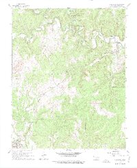 1906 Nelagoney1975 Print · USGSOsage County is captured here during a mid-century era of petroleum production and rail transit. Researchers can trace the routes of the Missouri Kansas Texas railroad and locate small stops like Okesa, Kiheki, and the Boy Scout Camp.
 - 1909 Map of Pawhuska, 1957 Print
 1909 Pawhuska1957 Print · USGSOsage County comes alive in this turn-of-the-century survey of the terrain around Pawhuska and its neighboring rail towns. Trace the paths of three major railroads as they pass through Barnsdall, find landmarks like Daltons Caves, or locate the White Swan Ford.
End of results
Showing maps 1-2 of 2
Top cities of Osage County
- Pawhuska historical maps
- Hominy historical maps
- Fairfax historical maps
- Barnsdall historical maps
- Wynona historical maps
- Shidler historical maps
See more
Frequently asked questions
- What are the different types of historical maps available for Osage County?
- What is the oldest map of Osage County?
- Where can I purchase historical maps of Osage County for my home or office?
- Where can I download high-res historical maps of Osage County?
- Are there historical topographic maps available for Osage County?
- Is there historical aerial imagery available for Osage County?
- Where are historical maps of Osage County sourced from?