1990s Maps of Stephens County, Oklahoma
Explore 4 historic maps of Stephens County from the 1990s. These maps offer a rare glimpse into what life looked like during the 1990s — showing old roads, neighborhoods, homes, and landmarks that have changed or disappeared over time.
Whether you're researching your family's past, planning a metal detecting trip, or studying how Stephens County's landscape evolved across the 1990s, these high-resolution maps are a powerful tool for exploring the history of this region.
- Focus on a specific era: All maps on this page are from the 1990s, giving you a focused view of this time period.
- See what’s changed: Compare century-old streets, trails, and buildings to today's modern landscape using overlays and satellite layers.
- Research with precision: Use these maps for genealogy, historical research, land use analysis, or educational projects.
- View, download, or print: Maps are fully viewable online in high resolution, and can be downloaded or printed for your own records.
Start exploring Stephens County's history through authentic maps from the 1990s. This is your window into the past.
Stephens County, OK maps
(4)- 1991 Map of Denton
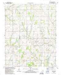 1991 Denton1991 Print · USGSThe Oklahoma prairie at the start of the 1990s reveals a landscape defined by an active gas and oil field spanning three county lines. Genealogists and historians can trace family-named sites like Burris alongside the Woodlawn Cem and the Hurley Grove Community House.
 - 1991 Map of Letitia
 1991 Letitia1991 Print · USGSSouthern Oklahoma at the start of the nineties shows a landscape where petroleum production and farming coexist. Researchers can trace rural community centers like Pumpkin Center and Letitia, along with Hulen Church and the local Cemetery.
 - 1991 Map of Sterling
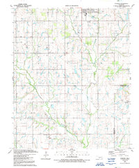 1991 Sterling1991 Print · USGSThe ranching and energy country of the Oklahoma prairie is captured here in the early nineties. Genealogists and local historians can locate rural landmarks such as Midway Ch, the old settlement at Denton, and the concentrated Oil Field near Coxs Corner.
 - 1991 Map of Nellie
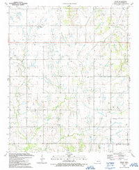 1991 Nellie1991 Print · USGSStephens County petroleum country is captured here in the early nineties, showing the dense intersection of energy production and rural community life. Researchers can trace family roots at Rock Creek Cemetery or locate landmarks like Oil City, Nellie, and the Central High School.
End of results
Showing maps 1-4 of 4
Top cities of Stephens County
- Duncan historical maps
- Marlow historical maps
- Comanche historical maps
- Bray historical maps
- Central High historical maps
- Empire City historical maps
See more
Frequently asked questions
- What are the different types of historical maps available for Stephens County?
- What is the oldest map of Stephens County?
- Where can I purchase historical maps of Stephens County for my home or office?
- Where can I download high-res historical maps of Stephens County?
- Are there historical topographic maps available for Stephens County?
- Is there historical aerial imagery available for Stephens County?
- Where are historical maps of Stephens County sourced from?