1960s Maps of Stephens County, Oklahoma
Explore 6 historic maps of Stephens County from the 1960s. These maps offer a rare glimpse into what life looked like during the 1960s — showing old roads, neighborhoods, homes, and landmarks that have changed or disappeared over time.
Whether you're researching your family's past, planning a metal detecting trip, or studying how Stephens County's landscape evolved across the 1960s, these high-resolution maps are a powerful tool for exploring the history of this region.
- Focus on a specific era: All maps on this page are from the 1960s, giving you a focused view of this time period.
- See what’s changed: Compare century-old streets, trails, and buildings to today's modern landscape using overlays and satellite layers.
- Research with precision: Use these maps for genealogy, historical research, land use analysis, or educational projects.
- View, download, or print: Maps are fully viewable online in high resolution, and can be downloaded or printed for your own records.
Start exploring Stephens County's history through authentic maps from the 1960s. This is your window into the past.
Stephens County, OK maps
(6)- 1962 Map of Temple, 1964 Print
 1962 Temple1964 Print · USGSThe cotton and oil country of southwestern Oklahoma comes to life here in the early sixties. Genealogists and historians can trace the foundations of Temple and Corum, locating family landmarks like Shakelford Cem and the Lone Star Ch.2 unique versions available
 - 1963 Map of Ardmore
 1963 Ardmore1963 Print · USGSSouthern Oklahoma during the early sixties shows a landscape defined by the Arbuckle Mountains and a booming energy economy. Genealogists and historians can trace family-named sites across the Ardmore Oil Field, find old schools like Southeastern State College, or locate historic markers such as Boggy Depot State Park.2 unique versions available
 - 1963 Map of Harrisburg, 1964 Print
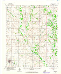
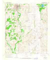
 1963 Harrisburg1964 Print · USGSStephens County, Oklahoma, is shown in the early 1960s as a landscape shaped by both cattle country and the booming petroleum industry. Researchers can trace the layout of the Harrisburg settlement or locate family sites at Stoner Cem and Fairview Ch.2 unique versions available
 - 1964 Map of Comanche SE, 1965 Print
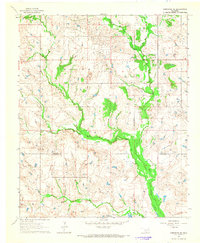 1964 Comanche SE1965 Print · USGSSouthern Oklahoma in the early sixties was a landscape of remote rural communities and active energy extraction. Genealogists and historians can trace family locations near Woolsey Cem and the small settlements of Brown and Loco.2 unique versions available
 - 1964 Map of Duncan South, 1965 Print
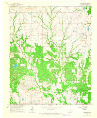
 1964 Duncan South1965 Print · USGSStephens County in the mid-1960s shows a landscape defined by its petroleum industry and deep territorial roots. Genealogists can trace family sites at Henderson-Harris Cem and Fairview Cem or locate old schools like Liberty Sch.2 unique versions available
 - 1964 Map of Comanche, 1965 Print
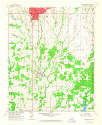
 1964 Comanche1965 Print · USGSThe city of Comanche and the surrounding Stephens County countryside are captured here in the mid-sixties as the oil industry and rail lines shaped the landscape. Genealogists and historians can trace the Old Oklahoma Territory Indian Territory Boundary Line or locate rural landmarks like Countryside Ch and the High Sch.2 unique versions available
End of results
Showing maps 1-6 of 6
Top cities of Stephens County
- Duncan historical maps
- Marlow historical maps
- Comanche historical maps
- Bray historical maps
- Central High historical maps
- Empire City historical maps
See more
Frequently asked questions
- What are the different types of historical maps available for Stephens County?
- What is the oldest map of Stephens County?
- Where can I purchase historical maps of Stephens County for my home or office?
- Where can I download high-res historical maps of Stephens County?
- Are there historical topographic maps available for Stephens County?
- Is there historical aerial imagery available for Stephens County?
- Where are historical maps of Stephens County sourced from?