1980s Maps of Stephens County, Oklahoma
Explore 12 historic maps of Stephens County from the 1980s. These maps offer a rare glimpse into what life looked like during the 1980s — showing old roads, neighborhoods, homes, and landmarks that have changed or disappeared over time.
Whether you're researching your family's past, planning a metal detecting trip, or studying how Stephens County's landscape evolved across the 1980s, these high-resolution maps are a powerful tool for exploring the history of this region.
- Focus on a specific era: All maps on this page are from the 1980s, giving you a focused view of this time period.
- See what’s changed: Compare century-old streets, trails, and buildings to today's modern landscape using overlays and satellite layers.
- Research with precision: Use these maps for genealogy, historical research, land use analysis, or educational projects.
- View, download, or print: Maps are fully viewable online in high resolution, and can be downloaded or printed for your own records.
Start exploring Stephens County's history through authentic maps from the 1980s. This is your window into the past.
Stephens County, OK maps
(12)- 1981 Map of Lawton
 1981 Lawton1981 Print · USGSSouthwestern Oklahoma in the early eighties shows a landscape shaped by military history and the rising peaks of the Wichitas. Researchers can trace the boundaries of the Fort Sill Military Reservation and locate early settlements like Meers, Chattanooga, and Richards Spur.
 - 1981 Map of Marlow
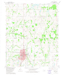 1981 Marlow1981 Print · USGSMarlow and the surrounding Stephens County oil fields are captured here in the early eighties. Genealogists and local historians can trace the town’s layout from Marlow Cem to residential streets like Caddo Ave and landmarks such as the Armory.
 - 1982 Map of Hope
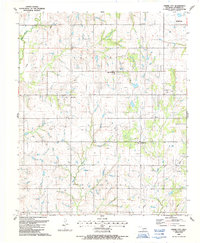
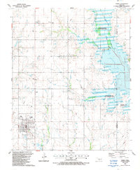
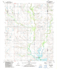
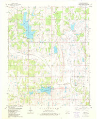 1982 Hope1982 Print · USGSStephens County in the early eighties shows a landscape of growing reservoirs and active oil production near the town of Bray. Genealogists and local historians can locate Cooper Cem, trace the waters of Wildhorse Creek, or find Camp Waluhiyi.
 - 1982 Map of Bray
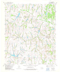 1982 Bray1982 Print · USGSThe rural border of Grady and Stephens counties is captured in the early eighties as a landscape of creeks and energy production. Genealogists and local historians can locate the Bray Church, the town of Bailey, and the community of Wall near Rush Creek.
 - 1982 Map of Duncan North
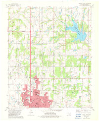 1982 Duncan North1982 Print · USGSStephens County enters the 1980s with a landscape defined by the growth of Duncan and the expanding waters of Lake Humphreys. Researchers can trace neighborhood development through numerous local landmarks like Lee Sch, Old Duncan Cem, and the Copland Landing Strip.
 - 1985 Map of Burkburnett, 1986 Print
 1985 Burkburnett1986 Print · USGSThe Red River valley and North Texas oil fields are captured here in the mid-eighties, showing the vital connection between military hubs and rail towns. Researchers can trace the path of the Missouri Kansas Texas railroad through Burkburnett or locate Waurika Lake and Sheppard Air Force Base.2 unique versions available
 - 1986 Map of Ardmore
 1986 Ardmore1986 Print · USGSSouthern Oklahoma in the mid-eighties was a landscape of rugged geology and deep petroleum roots. Genealogists and historians can trace the development of Ardmore and Healdon alongside the vast Sholem Alechem Oil Field and the rails of the AT & SF RR.2 unique versions available
 - 1986 Map of Pauls Valley
 1986 Pauls Valley1986 Print · USGSGarvin County and its neighbors are shown in the mid-1980s during a period of steady growth along the Washita River. Researchers can trace the path of the Atchison Topeka and Santa Fe railroad through Pauls Valley or locate rural sites like Mt Olive Church and Erin Springs.2 unique versions available
 - 1987 Map of Empire City, 1988 Print
 1987 Empire City1988 Print · USGSEmpire City and the surrounding Oklahoma oil fields are documented here in the late 1980s. Local researchers can trace rural life and industry through the sites of Empire Sch, Oak Grove Cem, and the grid of Oil Wells around Gas City.
 - 1987 Map of Temple, 1988 Print
 1987 Temple1988 Print · USGSTemple and the surrounding plains are captured in the late eighties as the local landscape adapted to the presence of Waurika Lake. Genealogists and historians can trace family locations near Temple Cem, Valley View Ch, and the settlement of Mills.
 - 1987 Map of Temple NW, 1988 Print
 1987 Temple NW1988 Print · USGSCotton County during the late 1980s reveals a rural landscape deeply integrated with the petroleum industry. Genealogists and local historians can locate Comanche Cem, trace the course of Beaver Creek, and identify small communities like Hulen.
 - 1987 Map of Corum, 1988 Print
 1987 Corum1988 Print · USGSSouthern Oklahoma during the late eighties reveals a landscape transformed by the reservoir waters of Waurika Lake at the county line. Genealogists and local historians can trace the foundations of Corum, locate the Grandview School, and follow the historic path of the Chisholm Trail.
End of results
Showing maps 1-12 of 12
Top cities of Stephens County
- Duncan historical maps
- Marlow historical maps
- Comanche historical maps
- Bray historical maps
- Central High historical maps
- Empire City historical maps
See more
Frequently asked questions
- What are the different types of historical maps available for Stephens County?
- What is the oldest map of Stephens County?
- Where can I purchase historical maps of Stephens County for my home or office?
- Where can I download high-res historical maps of Stephens County?
- Are there historical topographic maps available for Stephens County?
- Is there historical aerial imagery available for Stephens County?
- Where are historical maps of Stephens County sourced from?