1970s Maps of Woods County, Oklahoma
Explore 8 historic maps of Woods County from the 1970s. These maps offer a rare glimpse into what life looked like during the 1970s — showing old roads, neighborhoods, homes, and landmarks that have changed or disappeared over time.
Whether you're researching your family's past, planning a metal detecting trip, or studying how Woods County's landscape evolved across the 1970s, these high-resolution maps are a powerful tool for exploring the history of this region.
- Focus on a specific era: All maps on this page are from the 1970s, giving you a focused view of this time period.
- See what’s changed: Compare century-old streets, trails, and buildings to today's modern landscape using overlays and satellite layers.
- Research with precision: Use these maps for genealogy, historical research, land use analysis, or educational projects.
- View, download, or print: Maps are fully viewable online in high resolution, and can be downloaded or printed for your own records.
Start exploring Woods County's history through authentic maps from the 1970s. This is your window into the past.
Woods County, OK maps
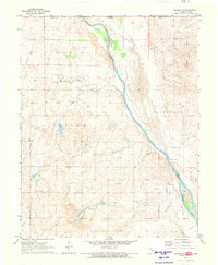
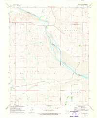
(8)- 1970 Map of Lookout, 1972 Print
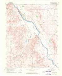
 1970 Lookout1972 Print · USGSThe Oklahoma-Kansas borderlands in the early 1970s reveal a landscape shaped by the energy industry and rural community life. Researchers can trace the sprawling Patterson Oil and Gas Field and locate landmarks like Lookout Ch and the Coy Community Hall.
 - 1970 Map of Freedom NE, 1972 Print
 1970 Freedom NE1972 Print · USGSThe Oklahoma-Kansas state line area in the early seventies shows a landscape of drainage creeks and rural industry. Researchers can trace the development of the plains via local landmarks like Yellowstone Creek, several Gas Wells, and the Landing Strip.
 - 1970 Map of Fairvalley, 1972 Print
 1970 Fairvalley1972 Print · USGSNorthwest Oklahoma's prairie landscape at the start of the seventies is defined by the winding Cimarron River and its rugged breaks. Genealogists and local historians can trace the rural communities of Fairvalley and Redhorse along the Atchison Topeka and Santa Fe railroad.
 - 1970 Map of Freedom NW, 1972 Print
 1970 Freedom NW1972 Print · USGSThe Oklahoma-Kansas borderlands in the early 1970s are captured here, showing the rural townships of Patterson and Obryan. Genealogists and historians can trace local landmarks like Cowboy Cem and the drainage of Moccasin Creek.
 - 1970 Map of Edith, 1972 Print
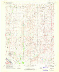
 1970 Edith1972 Print · USGSOklahoma's high plains and the winding Cimarron River valley are captured here in the early seventies, showing a landscape defined by ranching and rail. Genealogists and historians can trace the Atchison Topeka and Santa Fe railroad through the settlement of Edith and locate the Mount Pleasant Cem.
 - 1970 Map of Freedom, 1972 Print
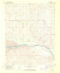
 1970 Freedom1972 Print · USGSThe town of Freedom and the Cimarron River valley are captured in the early seventies, showing a landscape shaped by ranching and the energy industry. Genealogists and historians can trace local landmarks like Fairy Sch, Preston Hill Cem, and the Atchison Topeka and Santa Fe rail line.
 - 1970 Map of Selman NW, 1973 Print
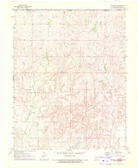
 1970 Selman NW1973 Print · USGSThe Oklahoma-Kansas borderlands come into focus in the early 1970s as industrial exploration meets traditional ranching. Local researchers can locate the Lutheran Cem, the rural settlement of Lodge, and numerous Gas Wells along the Cimarron River.
 - 1971 Map of Selman SE, 1973 Print
 1971 Selman SE1973 Print · USGSNorthwestern Oklahoma’s river valley is captured here in the early seventies, where three counties meet along the sandy bends of the Cimarron River. Researchers can trace the Atchison Topeka and Santa Fe line or locate family sites at Spring Valley Cem and Nixon Cem.
End of results
Showing maps 1-8 of 8
Top cities of Woods County
- Alva historical maps
- Waynoka historical maps
- Freedom historical maps
- Dacoma historical maps
- Capron historical maps
- Avard historical maps
Frequently asked questions
- What are the different types of historical maps available for Woods County?
- What is the oldest map of Woods County?
- Where can I purchase historical maps of Woods County for my home or office?
- Where can I download high-res historical maps of Woods County?
- Are there historical topographic maps available for Woods County?
- Is there historical aerial imagery available for Woods County?
- Where are historical maps of Woods County sourced from?