1980s Maps of Woods County, Oklahoma
Explore 6 historic maps of Woods County from the 1980s. These maps offer a rare glimpse into what life looked like during the 1980s — showing old roads, neighborhoods, homes, and landmarks that have changed or disappeared over time.
Whether you're researching your family's past, planning a metal detecting trip, or studying how Woods County's landscape evolved across the 1980s, these high-resolution maps are a powerful tool for exploring the history of this region.
- Focus on a specific era: All maps on this page are from the 1980s, giving you a focused view of this time period.
- See what’s changed: Compare century-old streets, trails, and buildings to today's modern landscape using overlays and satellite layers.
- Research with precision: Use these maps for genealogy, historical research, land use analysis, or educational projects.
- View, download, or print: Maps are fully viewable online in high resolution, and can be downloaded or printed for your own records.
Start exploring Woods County's history through authentic maps from the 1980s. This is your window into the past.
Woods County, OK maps
(6)- 1980 Map of Protection SW
 1980 Protection SW1980 Print · USGSComanche County during the late 1970s reveals a prairie landscape shaped by historic demarcations and river systems. Genealogists and historians can trace the Old Indian Treaty Boundary and locate the Mennonite Cem near the banks of Cavalry Creek.
 - 1980 Map of Buttermilk
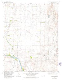
 1980 Buttermilk1980 Print · USGSSouthern Kansas and the Oklahoma borderlands are mapped here in the late seventies, showing a landscape defined by ranching and historic lines. Genealogists and researchers can trace the Old Indian Treaty Boundary and find local landmarks like Antioch Ch and the settlement of Buttermilk.
 - 1985 Map of Buffalo
 1985 Buffalo1985 Print · USGSNorthwest Oklahoma in the mid-eighties was a landscape of river basins and rail lines centered around Buffalo and Laverne. Genealogists and historians can trace the paths of the Atchison Topeka and Santa Fe Railroad or locate landmarks like Chimney Rock and Alabaster Caverns.2 unique versions available
 - 1985 Map of Protection
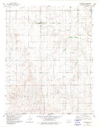
 1985 Protection1985 Print · USGSThe Kansas-Oklahoma borderlands in the 1980s are defined by agricultural settlements and historical survey lines. Genealogists and historians can trace the Old Indian Treaty Boundary and locate family names near Crown Hill Cem or the town of Protection.2 unique versions available
 - 1985 Map of Alva, 1986 Print
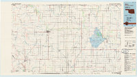 1985 Alva1986 Print · USGSNorthern Oklahoma in the mid-eighties was a landscape of rail-connected prairie towns and unique geologic features. Researchers can trace the legacy of the ATCHISON TOPEKA AND SANTA FE through Alva, locate the State School for Boys, or explore the boundaries of the Great Salt Plains Reservoir.
 - 1986 Map of Fairview
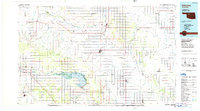 1986 Fairview1986 Print · USGSMajor County and the Cimarron River valley are shown here in the mid-1980s as the rail networks of the Atchison Topeka and Santa Fe still linked the plains. Researchers can trace rural lineages through settlements like Cheyenne Valley, Bouse Junction, and the terrain surrounding Canton Lake.2 unique versions available
End of results
Showing maps 1-6 of 6
Top cities of Woods County
- Alva historical maps
- Waynoka historical maps
- Freedom historical maps
- Dacoma historical maps
- Capron historical maps
- Avard historical maps
Frequently asked questions
- What are the different types of historical maps available for Woods County?
- What is the oldest map of Woods County?
- Where can I purchase historical maps of Woods County for my home or office?
- Where can I download high-res historical maps of Woods County?
- Are there historical topographic maps available for Woods County?
- Is there historical aerial imagery available for Woods County?
- Where are historical maps of Woods County sourced from?