1960s Maps of Clackamas County, Oregon
Explore 25 historic maps of Clackamas County from the 1960s. These maps offer a rare glimpse into what life looked like during the 1960s — showing old roads, neighborhoods, homes, and landmarks that have changed or disappeared over time.
Whether you're researching your family's past, planning a metal detecting trip, or studying how Clackamas County's landscape evolved across the 1960s, these high-resolution maps are a powerful tool for exploring the history of this region.
- Focus on a specific era: All maps on this page are from the 1960s, giving you a focused view of this time period.
- See what’s changed: Compare century-old streets, trails, and buildings to today's modern landscape using overlays and satellite layers.
- Research with precision: Use these maps for genealogy, historical research, land use analysis, or educational projects.
- View, download, or print: Maps are fully viewable online in high resolution, and can be downloaded or printed for your own records.
Start exploring Clackamas County's history through authentic maps from the 1960s. This is your window into the past.
Clackamas County, OR maps
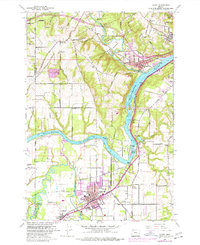
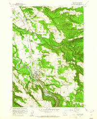
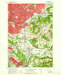
(25)- 1960 Map of Estacada
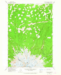
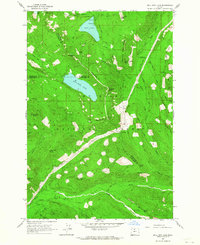
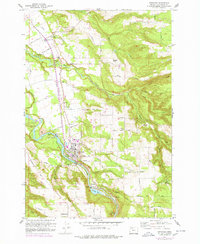 1960 Estacada1960 Print · USGSClackamas County communities and river-based industry thrive in the early 1960s along the Clackamas River. Genealogists and researchers can trace the Abandoned Railroad through Eagle Creek or locate the River Mill Powerhouse and Forrester Cem.
 - 1960 Map of Salem, 1968 Print
 1960 Salem1968 Print · USGSThe Willamette Valley and the surrounding mountain ranges are shown here in the 1960s during a period of significant reservoir construction. Genealogists and historians can trace rail lines like the Oregon Electric and find communities from Lincoln City on the coast to Sweet Home and Mill City in the foothills.2 unique versions available
 - 1961 Map of Oregon City
 1961 Oregon City1961 Print · USGSOregon City and the Willamette River corridor are captured here in the early sixties as industrial rail networks and rural school districts still defined the local landscape. Genealogists can locate family landmarks from Mountain View Cemetery to Beaver Creek School and Fishers Corner.3 unique versions available
 - 1961 Map of Redland
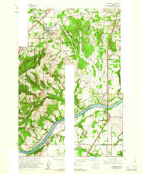
 1961 Redland1961 Print · USGSClackamas County was a patchwork of small farming communities and river landings in the early sixties. Genealogists can trace the rural school districts of Fir Grove Sch and Shubel Sch or locate the historic Fischers Mill and Feldheimer Ferry (Site).5 unique versions available
 - 1961 Map of Sandy
 1961 Sandy1961 Print · USGSThe Clackamas and Multnomah County line during the early sixties shows a landscape of growing rural communities and deep river valleys. Genealogists and local historians can locate specific family-named roads and landmarks like Cottrell School, the Fish Hatchery, and the town of Boring.6 unique versions available
 - 1961 Map of Canby
 1961 Canby1961 Print · USGSThe riverfront communities south of Portland were thriving rail and water hubs in the early sixties. Researchers can trace family sites at the Robert Bird Cemetery or locate the historic Eccles Sch and New Era settlement along the Southern Pacific tracks.4 unique versions available
 - 1961 Map of Damascus
 1961 Damascus1961 Print · USGSSoutheast of Portland in the early sixties, this area shows the suburban transition between Gresham and Boring. Genealogists and historians can locate the Sunnyside Church, trace the Portland Traction Co rail line, or find family-named landmarks like Walters Hill.4 unique versions available
 - 1961 Map of Estacada
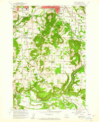
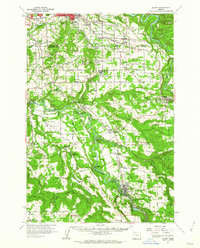
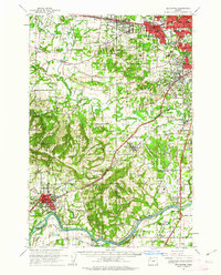
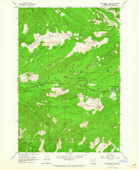
 1961 Estacada1961 Print · USGSClackamas County hydroelectric power and timber transport define this early 1960s study of the Estacada area. Researchers can trace the Portland Traction Co rail line or locate family sites like Forrester Cem and the settlement of Currinsville.4 unique versions available
 - 1961 Map of Sherwood
 1961 Sherwood1961 Print · USGSThe northern Willamette Valley in the early sixties is a landscape of thriving river towns and developing highways. Genealogists and historians can locate Butteville Cem, the Dammasch State Hospital, and rail stops like Butteville Station.5 unique versions available
 - 1961 Map of Gladstone, 1962 Print
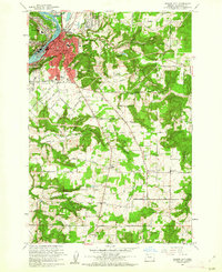
 1961 Gladstone1962 Print · USGSClackamas and Multnomah Counties are seen here during a period of rapid suburban expansion in the early sixties. Genealogists and local historians can trace family roots through numerous neighborhood schools and cemeteries, or locate landmarks like Lents Junction, Gladstone Sta, and the Watson Dwyer Landing Field.6 unique versions available
 - 1961 Map of Sandy, 1962 Print
 1961 Sandy1962 Print · USGSClackamas County was a landscape of river-driven industry and rural crossroads in the early sixties. Researchers can trace historic river crossings at the Feldheimer Ferry (Site), find the Fischers Mill site, and locate early schools like Damascus Union Sch.
 - 1961 Map of Oregon City, 1963 Print
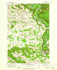
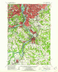 1961 Oregon City1963 Print · USGSThe Willamette River corridor south of Portland is seen here in the early sixties as suburban growth meets long-standing river towns. Genealogists and historians can trace the foundations of Oregon City, Milwaukie, and Canemah, alongside landmarks like Willamette National Cem and Camp Withycombe.
 - 1961 Map of Fort Butte, 1963 Print
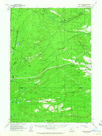 1961 Fort Butte1963 Print · USGSThe high Cascades of Wasco and Jefferson counties are captured here in the early sixties, showing a landscape shaped by timber and range. Researchers can trace the drainage of Shitike Creek or locate local landmarks like Old Mill Camp and the Schoolie Pasture.2 unique versions available
 - 1961 Map of Beaverton, 1963 Print
 1961 Beaverton1963 Print · USGSWashington County undergoes a post-war transition in the early sixties as suburban grids meet the farms of the Tualatin Valley. Researchers can trace family roots through numerous country schools like Witch Hazel Sch or find regional landmarks like Dammasch State Hospital and Champoeg State Park.
 - 1961 Map of Breitenbush Hot Springs, 1964 Print
 1961 Breitenbush Hot Springs1964 Print · USGSThe Oregon Cascades in the early 1960s are documented here during a period of active Forest Service management and recreational growth. Trace the development of Breitenbush Hot Springs or locate remote landmarks like the Rho Ridge Shelter and the Clackamas Ranger Sta.3 unique versions available
 - 1961 Map of Lake Oswego, 1971 Print
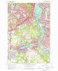 1961 Lake Oswego1971 Print · USGSThe suburbs south of Portland are in full development during the early sixties, centered on the Willamette River and the expanding residential reaches of Lake Oswego. Researchers can trace the grounds of Reed College, locate the Beth Israel Cem, or follow the Southern Pacific rail line through West Portland.5 unique versions available
 - 1962 Map of Salem
 1962 Salem1962 Print · USGSThe Willamette Valley and the surrounding Oregon ranges are captured here in the early sixties, showing the vital growth of the state's primary agricultural and academic corridor. Researchers can trace the mid-century footprints of Oregon State University and the University of Oregon, alongside rural landmarks like Camp Adair and Black Butte Mine.
 - 1962 Map of Hickman Butte, 1963 Print
 1962 Hickman Butte1963 Print · USGSThe Oregon Cascades in the early sixties reveal a landscape of forestry lookouts and remote alpine camps. Researchers can trace historic access routes like Lolo Pass Road and locate landmarks such as Hickman Butte Lookout and Red Cedar Camp.4 unique versions available
 - 1962 Map of Cathedral Ridge, 1964 Print
 1962 Cathedral Ridge1964 Print · USGSThe northern slopes of the Cascades are documented here in the early sixties, showing a landscape defined by active ice fields and early mountain tourism. Hikers and historians can trace the paths to Cloud Cap Inn, the Red Hill Guard Station, and the high waters of Dollar Lake.4 unique versions available
 - 1962 Map of Government Camp, 1964 Print
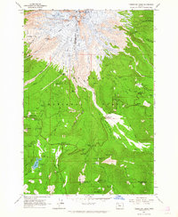
 1962 Government Camp1964 Print · USGSGovernment Camp and the high ridges of the Cascades are captured in the early sixties as the region solidified its role in mountaineering and recreation. Trace the historic paths of the Skyline Trail and Pioneer Bridle Trail or locate early forest fire lookouts at Zigzag East Lookout and Devils Peak Lookout.4 unique versions available
 - 1962 Map of Timberline Lodge, 1964 Print
 1962 Timberline Lodge1964 Print · USGSMount Hood and its surrounding national forest in the early sixties reveal a landscape of glaciated peaks and rising alpine tourism. Trace historic transit routes like the Barlow Road and explore landmarks such as Timberline Lodge and Trillium Lake.3 unique versions available
 - 1962 Map of Rhododendron, 1964 Print
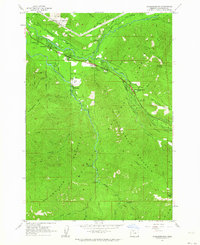 1962 Rhododendron1964 Print · USGSThe Clackamas County high country at the start of the 1960s shows a landscape of mountain settlements and forest service outposts. Genealogists and hikers can trace the original sites of Welches Sch, the West Zigzag Lookout, and the historic Pioneer Bridle Trail.3 unique versions available
 - 1962 Map of Bull Run Lake, 1964 Print
 1962 Bull Run Lake1964 Print · USGSMount Hood's wilderness and protected watersheds are captured in the early sixties, showing the rugged backcountry before modern development. Researchers can trace the path of the Skyline Trail and locate historic sites like the Ranger Station and Bals Mtn Shelter.3 unique versions available
 - 1963 Map of Salem
 1963 Salem1963 Print · USGSMid-century Oregon comes into focus as the Willamette Valley’s timber and agricultural industries meet the growing campuses of Oregon State University and the University of Oregon. Researchers can trace old rail lines like the Oregon Electric Railway and locate family plots at Siletz Cem or Dallas Cem.
 - 1964 Map of Vancouver
 1964 Vancouver1964 Print · USGSThe Pacific Northwest interior and coast are shown here in the 1960s, from the Portland metropolitan hub to the rugged Pacific shoreline. Researchers can trace the legacy of the Grand Ronde Indian Reservation, the early layout of McMinnville, and the maritime approaches near Tillamook Head.
End of results
Showing maps 1-25 of 25
Top cities of Clackamas County
- Lake Oswego historical maps
- Oregon City historical maps
- West Linn historical maps
- Wilsonville historical maps
- Happy Valley historical maps
- Milwaukie historical maps
See more
Frequently asked questions
- What are the different types of historical maps available for Clackamas County?
- What is the oldest map of Clackamas County?
- Where can I purchase historical maps of Clackamas County for my home or office?
- Where can I download high-res historical maps of Clackamas County?
- Are there historical topographic maps available for Clackamas County?
- Is there historical aerial imagery available for Clackamas County?
- Where are historical maps of Clackamas County sourced from?