1970s Maps of Clackamas County, Oregon
Explore 3 historic maps of Clackamas County from the 1970s. These maps offer a rare glimpse into what life looked like during the 1970s — showing old roads, neighborhoods, homes, and landmarks that have changed or disappeared over time.
Whether you're researching your family's past, planning a metal detecting trip, or studying how Clackamas County's landscape evolved across the 1970s, these high-resolution maps are a powerful tool for exploring the history of this region.
- Focus on a specific era: All maps on this page are from the 1970s, giving you a focused view of this time period.
- See what’s changed: Compare century-old streets, trails, and buildings to today's modern landscape using overlays and satellite layers.
- Research with precision: Use these maps for genealogy, historical research, land use analysis, or educational projects.
- View, download, or print: Maps are fully viewable online in high resolution, and can be downloaded or printed for your own records.
Start exploring Clackamas County's history through authentic maps from the 1970s. This is your window into the past.
Clackamas County, OR maps
(3)- 1975 Map of Gladstone, 1977 Print
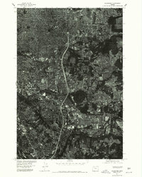 1975 Gladstone1977 Print · USGSGreater Portland and the riverside communities of Clackamas County are captured in high-detail aerial imagery during the mid-seventies. Researchers can trace the development of Gladstone near the Willamette River or study the terrain around Mount Scott.
 - 1975 Map of Canby, 1977 Print
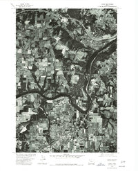 1975 Canby1977 Print · USGSThe northern Willamette Valley in the mid-seventies reveals a mix of riverside industry and expanding orchard lands. Trace the development of Canby and West Linn along the banks of the Willamette River and the Tualatin River.
 - 1975 Map of Damascus, 1985 Print
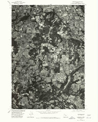 1975 Damascus1985 Print · USGSClackamas County is captured in the mid-1970s as a patchwork of timber and farmland during a period of steady rural growth. Researchers can trace the development of Damascus and Boring while examining the wooded slopes of Walters Hill.
End of results
Showing maps 1-3 of 3
Top cities of Clackamas County
- Lake Oswego historical maps
- Oregon City historical maps
- West Linn historical maps
- Wilsonville historical maps
- Happy Valley historical maps
- Milwaukie historical maps
See more
Frequently asked questions
- What are the different types of historical maps available for Clackamas County?
- What is the oldest map of Clackamas County?
- Where can I purchase historical maps of Clackamas County for my home or office?
- Where can I download high-res historical maps of Clackamas County?
- Are there historical topographic maps available for Clackamas County?
- Is there historical aerial imagery available for Clackamas County?
- Where are historical maps of Clackamas County sourced from?