Old Maps of Clackamas County, Oregon for Academic Research
Study the evolution of Clackamas County with 333 high-resolution historic maps. Whether you're teaching, researching, or modeling changes in land use, these maps provide essential visual documentation of urban, environmental, and geographic change.
- Analyze long-term change: Track patterns in development, transportation, and natural features.
- Ideal for environmental or urban studies: Support academic projects with primary historical map data.
- Use in the classroom or lab: Educators and researchers rely on these maps to bring historical context to life.
These maps are a powerful tool for teaching, research, and visualizing how Clackamas County has changed over the decades.
Clackamas County, OR maps
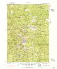
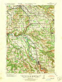
(333)- 1911 Map of Boring
 1911 Boring1911 Print · USGSClackamas County was a patchwork of small farming communities and emerging rail hubs in the decade before the First World War. Researchers can trace the early footprints of settlements like Boring and Gresham, alongside family landmarks such as Peterson Crossroads and Sycamore School.
 - 1914 Map of Boring
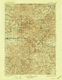
 1914 Boring1914 Print · USGSThe Clackamas River valley was a hub of early twentieth-century logging and electric rail expansion between Gresham and Estacada. Genealogists and historians can trace defunct river crossings like McMurray Ferry and rural landmarks such as Fishers Mill and Stone School.3 unique versions available
 - 1914 Map of Oregon City
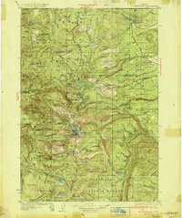
 1914 Oregon City1914 Print · USGSThe Willamette Valley at the start of the twentieth century was a landscape of rapid rail expansion and river-based industry. Researchers can trace early rural life through Wichita School and Lions Mill, or explore the growth of Oswego and Milwaukie.4 unique versions available
 - 1916 Map of Tualatin
 1916 Tualatin1916 Print · USGSThe northern Willamette Valley in the mid-1910s is a landscape of orchards and rail spurs, where river ferries still compete with new electric lines. Trace family roots at Champoeg Monument or explore old school sites like Grabel School and St Pauls School.5 unique versions available
 - 1916 Map of Estacada
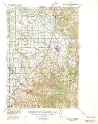
 1916 Estacada1916 Print · USGSClackamas County is captured here during a period of rapid hydroelectric and rail development just before the First World War. Researchers can trace early family homesteads near Fishers Mill, the old Feldbimer Ferry crossing, and the rail line serving Boring and Estacada.5 unique versions available
 - 1923 Map of Mount Angel
 1923 Mount Angel1923 Print · USGSMarion County in the early twenties is a landscape of thriving rail-towns and rural school districts connected by the Southern Pacific and Oregon Electric. Genealogists can trace early homesteads near Pioneers Cemetery or locate family roots at the US Indian School Chemawa and Belle Passi School.3 unique versions available
 - 1924 Map of Mount Hood, 1955 Print
 1924 Mount Hood1955 Print · USGSMount Hood and its surrounding high-country settlements are captured here in the mid-twenties during the rise of mountain recreation. Trace early roads and landmarks like the Mt Hood Loop Highway, Government Camp, and the original Timberline Cabin.2 unique versions available
 - 1927 Map of Mount Hood
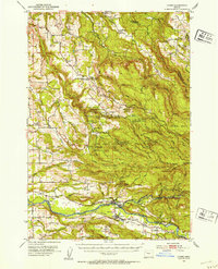
 1927 Mount Hood1927 Print · USGSThe northern Cascades transition from pioneer travel routes to early forest management in the mid-1920s. Researchers can trace the legendary Barlow Road, locate historic mountain retreats like the Cloud Cap Inn, and find early outposts at Government Camp.4 unique versions available
 - 1927 Map of Mt. Jefferson, 1956 Print
 1927 Mt. Jefferson1956 Print · USGSThe Oregon Cascades in the late twenties were defined by high-altitude trails and the early management of the Santiam and Mount Hood forests. Trace the historic Skyline Trail past remote outposts like Lemiti Ranger Sta and the Breitenbush Hot Sprs.2 unique versions available
 - 1929 Map of Mill City
 1929 Mill City1929 Print · USGSThe Oregon Cascades appear here in the late 1920s as a hub of timber, mining, and early forest management. Genealogists and historians can trace the Southern Pacific rail line through Mill City or locate remote sites like the Silver King Mine and Elkhorn School.4 unique versions available
 - 1930 Map of Mt. Jefferson
 1930 Mt. Jefferson1930 Print · USGSThe Oregon Cascades were a frontier of early forest management and tribal lands during the late 1920s. Researchers can locate remote administrative outposts like the Lemiti Ranger Sta, trace the thermal waters of Breitenbush Hot Sprs, and explore the high meadows of Independence Prairie.3 unique versions available
 - 1939 Map of Molalla, 1958 Print
 1939 Molalla1958 Print · USGSBefore the modernization of the Willamette Valley's rural roads, this region centered on Molalla was a patchwork of family timberlands and prairie farms. Genealogists can trace family names and small-scale industry through landmarks like Union Mills, Maplewood Grange, and Jacks Bridge.2 unique versions available
 - 1939 Map of Oregon City, 1958 Print
 1939 Oregon City1958 Print · USGSThe Willamette Valley during the late thirties shows a landscape defined by river industry and competing rail lines. Genealogists and historians can trace family-named sites and rural institutions like the Ten O'clock Church, Linns Mill, and Reed College.
 - 1939 Map of Tualatin, 1958 Print
 1939 Tualatin1958 Print · USGSThe Tualatin Valley and Willamette River corridor are captured here before mid-century growth transformed the region. Genealogists can trace family footprints through dozens of rural landmarks, from Miners Landing and Butteville Sta to Mountainside School.
 - 1940 Map of Tualatin
 1940 Tualatin1940 Print · USGSThe Tualatin Valley comes into sharp focus during the late 1930s, showing the early footprints of Beaverton and Tigard amid a vast network of rail lines. Researchers can trace historic family schoolhouses like Witch Hazel School and locate the original path of Boones Ferry Road near Wilsonville.
 - 1940 Map of Molalla
 1940 Molalla1940 Print · USGSClackamas and Marion counties are captured here just before the war, showing the fertile prairies and rising timbered foothills of the Willamette Valley. Researchers can trace ancestral property near Lone Elder, visit the Trinity Lutheran Church, or locate vanished logging landmarks like the Old Saw Mill.2 unique versions available
 - 1940 Map of Boring
 1940 Boring1940 Print · USGSClackamas and Multnomah Counties are captured in the late thirties, documenting a landscape shaped by the Clackamas River and electric rail lines. Trace the route of the Cazadero Line or locate family roots at Mt Zion Cem and Lusted School.
 - 1940 Map of Mount Angel
 1940 Mount Angel1940 Print · USGSMarion County farming and institutional life are captured here just before the war, showing a valley crisscrossed by rail and river. Genealogists can locate family landmarks like St Benedict, the Pioneer Cemetery, and nearly twenty rural schoolhouses.
 - 1941 Map of Oregon City
 1941 Oregon City1941 Print · USGSThe Lower Willamette Valley thrived on a mix of river power and rail transit in the early 1940s. Genealogists can trace family footprints across dozens of local school districts, from Petes Mountain School to Harmony School, and locate landmarks like Willamette Falls and the Ten O'clock Church.
 - 1948 Map of Vancouver, 1957 Print
 1948 Vancouver1957 Print · USGSPost-war growth transforms the river valleys of the Pacific Northwest as the timber and rail economy thrives. Trace family roots in Tillamook or Oregon City, and locate vanished landmarks like the spit at Bayocean or the Skamania Mine.
 - 1950 Map of Vancouver
 1950 Vancouver1950 Print · USGSCoastal Oregon and the lower Columbia River valley are captured in detail just after the war. Researchers can trace historic rail routes like the Southern Pacific or locate early settlements such as Vernonia, Gaston, and the Grand Ronde Indian Reservation.
 - 1950 Map of Vancouver, 1951 Print
 1950 Vancouver1951 Print · USGSThe Pacific Northwest urban corridor meets the rugged coast in the years following the war, showing the expansion of Portland and Vancouver. Genealogists and historians can trace the reach of the Southern Pacific RR and locate coastal communities like Tillamook, Seaside, and Tolovana Park.
 - 1951 Map of Lyons, 1953 Print
 1951 Lyons1953 Print · USGSThe North Santiam River valley and the cataracts of the Silver Creek watershed are captured here in the early 1950s. Genealogists and hikers can trace the original sites of Silver Falls City, the Fox Valley Cem, and the historic Couch Mansion.4 unique versions available
 - 1953 Map of Salem
 1953 Salem1953 Print · USGSMid-century Oregon comes to life through this detailed survey of the Willamette Valley and the adjacent Pacific coastline. Researchers can trace the rail lines of the Southern Pacific RR, visit rural hubs like Fairview School, or locate coastal landmarks like the Yaquina Head Lighthouse.
 - 1953 Map of The Dalles, 1965 Print
 1953 The Dalles1965 Print · USGSThe Columbia River Gorge at mid-century shows a region being transformed by massive hydroelectric dams and a growing highway network. Researchers can trace the development of The Dalles Dam, locate the Maryhill Museum, and find old rail stops in Rufus, Wishram, and Arlington.3 unique versions available
Showing maps 1-25 of 333
Top cities of Clackamas County
- Lake Oswego historical maps
- Oregon City historical maps
- West Linn historical maps
- Wilsonville historical maps
- Happy Valley historical maps
- Milwaukie historical maps
See more
Frequently asked questions
- What are the different types of historical maps available for Clackamas County?
- What is the oldest map of Clackamas County?
- Where can I purchase historical maps of Clackamas County for my home or office?
- Where can I download high-res historical maps of Clackamas County?
- Are there historical topographic maps available for Clackamas County?
- Is there historical aerial imagery available for Clackamas County?
- Where are historical maps of Clackamas County sourced from?