1940s Maps of Curry County, Oregon
Explore 9 historic maps of Curry County from the 1940s. These maps offer a rare glimpse into what life looked like during the 1940s — showing old roads, neighborhoods, homes, and landmarks that have changed or disappeared over time.
Whether you're researching your family's past, planning a metal detecting trip, or studying how Curry County's landscape evolved across the 1940s, these high-resolution maps are a powerful tool for exploring the history of this region.
- Focus on a specific era: All maps on this page are from the 1940s, giving you a focused view of this time period.
- See what’s changed: Compare century-old streets, trails, and buildings to today's modern landscape using overlays and satellite layers.
- Research with precision: Use these maps for genealogy, historical research, land use analysis, or educational projects.
- View, download, or print: Maps are fully viewable online in high resolution, and can be downloaded or printed for your own records.
Start exploring Curry County's history through authentic maps from the 1940s. This is your window into the past.
Curry County, OR maps
(9)- 1945 Map of Kerby
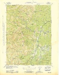 1945 Kerby1945 Print · USGSJosephine County at the close of the war shows a landscape of deep-woods mining and early forest management. Genealogists and historians can trace family roots through labels for Dryden Sch, the Hancock Ranch, and the early community at Takilma.
 - 1945 Map of Gasquet
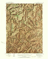
 1945 Gasquet1945 Print · USGSThe northern California mountains near the Oregon border are shown here during the mid-1940s, a period defined by remote mining and forest service outposts. Genealogists and historians can trace family locations and old worksites like Adams Station, the Tyson Chrome Co Mine, and the Lee Brown Ranch.
 - 1945 Map of Point St. George
 1945 Point St. George1945 Print · USGSCrescent City and the Del Norte coast are captured here mid-century, showing a landscape of timber, mines, and military outposts. Researchers can trace the Tyson Chrome Mine, find the Indian Cemetery, or locate the wartime Naval Airport.
 - 1946 Map of Galice, 1955 Print
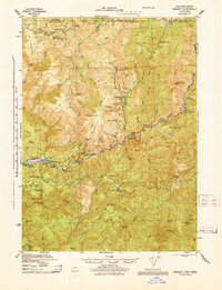
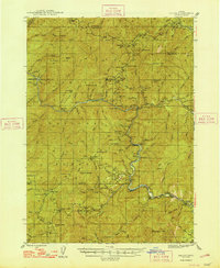
 1946 Galice1955 Print · USGSSouthern Oregon's Rogue River corridor is documented here in the mid-forties, highlighting a period when gold mining and forest service outposts defined the region. Researchers can trace the heritage of local claims like the Almeda Mine and settlements such as Galice and Rand.4 unique versions available
 - 1946 Map of Dutchman Butte, 1958 Print
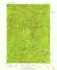
 1946 Dutchman Butte1958 Print · USGSThe high timber country of Douglas and Josephine counties is captured here in the mid-1940s during the height of fire-watch forestry. Researchers can trace the early Pacific Trail and locate isolated outposts like the Dutchman Butte Lookout and Bradford Warden Sta.6 unique versions available
 - 1948 Map of Galice
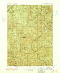
 1948 Galice1948 Print · USGSThe Rogue River canyon in the late 1940s reveals a landscape defined by remote forest camps and a storied mining history. Genealogists and historians can trace the locations of the Benton Mine, the riverside settlement of Galice, and Rainie Falls.2 unique versions available
 - 1948 Map of Dutchman Butte
 1948 Dutchman Butte1948 Print · USGSThe Oregon backcountry of Douglas and Curry counties is captured here in the late 1940s, showing a landscape of forest management and rail transport. Researchers can locate early fire lookouts and stations like Dutchman Butte Lookout and Bradford Warden Sta alongside the Southern Pacific line.2 unique versions available
 - 1948 Map of Weed, 1950 Print
 1948 Weed1950 Print · USGSNorthern California and Southern Oregon are captured here during the post-war era, documenting the mountain-and-valley economies of the Klamath and Cascade ranges. Trace the legacy of local mining and timber at the King Solomon Mine, find old schools like Siskiyou County School, and follow the historic Southern Pacific RR route.2 unique versions available
 - 1949 Map of Eureka
 1949 Eureka1949 Print · USGSCoastal Northern California in the late 1940s shows a landscape of timber towns and maritime outposts. You can trace the Northwestern Pacific rail line through Eureka or locate family landmarks like the Tyson Chrome Mine and Crescent City Lighthouse.2 unique versions available
End of results
Showing maps 1-9 of 9
Top cities of Curry County
Frequently asked questions
- What are the different types of historical maps available for Curry County?
- What is the oldest map of Curry County?
- Where can I purchase historical maps of Curry County for my home or office?
- Where can I download high-res historical maps of Curry County?
- Are there historical topographic maps available for Curry County?
- Is there historical aerial imagery available for Curry County?
- Where are historical maps of Curry County sourced from?