1960s Maps of Curry County, Oregon
Explore 5 historic maps of Curry County from the 1960s. These maps offer a rare glimpse into what life looked like during the 1960s — showing old roads, neighborhoods, homes, and landmarks that have changed or disappeared over time.
Whether you're researching your family's past, planning a metal detecting trip, or studying how Curry County's landscape evolved across the 1960s, these high-resolution maps are a powerful tool for exploring the history of this region.
- Focus on a specific era: All maps on this page are from the 1960s, giving you a focused view of this time period.
- See what’s changed: Compare century-old streets, trails, and buildings to today's modern landscape using overlays and satellite layers.
- Research with precision: Use these maps for genealogy, historical research, land use analysis, or educational projects.
- View, download, or print: Maps are fully viewable online in high resolution, and can be downloaded or printed for your own records.
Start exploring Curry County's history through authentic maps from the 1960s. This is your window into the past.
Curry County, OR maps
(5)- 1961 Map of Eureka
 1961 Eureka1961 Print · USGSThe Northern California coast and its deep redwood forests are mapped here at a time when the timber and rail industries defined the region. Researchers can trace historic family ranches and remote sites like Fort Dick, Table Bluff Lighthouse, and the Copper Creek Mine.2 unique versions available
 - 1962 Map of Coos Bay
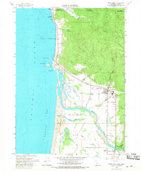
 1962 Coos Bay1962 Print · USGSThe Oregon coast at the end of the fifties reveals a landscape of timber ports and fishing villages connected by U.S. Highway 101. Researchers can trace the rail infrastructure of the Southern Pacific RR and locate early settlements from Florence down to Brookings.2 unique versions available
 - 1963 Map of Weed
 1963 Weed1963 Print · USGSNorthern California during the early 1960s shows a landscape of steep mountain ranges and river-fed valleys at the height of the timber era. Researchers can trace the routes of the McCloud River RR, locate remote sites like the Holiday Mine, or find ancestral markers at the Scott Valley Cem.
 - 1966 Map of High Divide, 1968 Print
 1966 High Divide1968 Print · USGSThe California-Oregon borderlands are revealed in the mid-sixties, a landscape defined by mountain ridges and the timberlands of the Siskiyou National Forest. Researchers can trace the legacy of remote mining at the Mountain View Mines and Alta Mine.
 - 1966 Map of Smith River, 1968 Print
 1966 Smith River1968 Print · USGSThe California-Oregon borderlands come alive in the mid-1960s, showing the intricate delta of the Smith River and the rural communities of the coastal plain. Genealogists and historians can trace family-named routes like Bailey Road and Fred D Haight Drive or locate the Yontocket (Site) near the river sloughs.2 unique versions available
End of results
Showing maps 1-5 of 5
Top cities of Curry County
Frequently asked questions
- What are the different types of historical maps available for Curry County?
- What is the oldest map of Curry County?
- Where can I purchase historical maps of Curry County for my home or office?
- Where can I download high-res historical maps of Curry County?
- Are there historical topographic maps available for Curry County?
- Is there historical aerial imagery available for Curry County?
- Where are historical maps of Curry County sourced from?