1970s Maps of Douglas County, Oregon
Explore 5 historic maps of Douglas County from the 1970s. These maps offer a rare glimpse into what life looked like during the 1970s — showing old roads, neighborhoods, homes, and landmarks that have changed or disappeared over time.
Whether you're researching your family's past, planning a metal detecting trip, or studying how Douglas County's landscape evolved across the 1970s, these high-resolution maps are a powerful tool for exploring the history of this region.
- Focus on a specific era: All maps on this page are from the 1970s, giving you a focused view of this time period.
- See what’s changed: Compare century-old streets, trails, and buildings to today's modern landscape using overlays and satellite layers.
- Research with precision: Use these maps for genealogy, historical research, land use analysis, or educational projects.
- View, download, or print: Maps are fully viewable online in high resolution, and can be downloaded or printed for your own records.
Start exploring Douglas County's history through authentic maps from the 1970s. This is your window into the past.
Douglas County, OR maps
(5)- 1970 Map of Crescent, 1973 Print
 1970 Crescent1973 Print · USGSCentral Oregon in the early seventies reveals a landscape of volcanic peaks and timber outposts connected by the Southern Pacific rail line. Researchers can trace the layout of Christmas Valley, locate Cabin Lake Ranger Station, and explore the geological footprint of Newberry Crater.
 - 1978 Map of Diamond Lake, 1994 Print
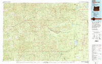 1978 Diamond Lake1994 Print · USGSThe Cascades of the late 1970s are seen here at a point of high-mountain industry and recreation across the Umpqua and Willamette forests. Researchers can trace the development of timber and water resources around Toketee Falls, Umpqua Mine, and Steamboat.2 unique versions available
 - 1979 Map of Roseburg
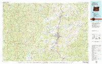 1979 Roseburg1979 Print · USGSThe Umpqua River valley and the foothills of the Coast Range are captured here during a period of active timber and mineral production in the late seventies. Researchers can trace the paths of the Southern Pacific and the Bonanza Mine alongside small settlements like Coles Valley and Nonpareil.
 - 1979 Map of Cottage Grove
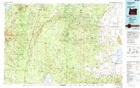
 1979 Cottage Grove1979 Print · USGSThe Oregon timber and rail corridors of the late seventies are documented here, centered on the Coast Fork Willamette River and the growing hub of Cottage Grove. Researchers can trace the path of the Southern Pacific railroad as it connects small stations like Divide, Saginaw, and Yoncalla.2 unique versions available
 - 1979 Map of Crescent, 1994 Print
 1979 Crescent1994 Print · USGSHigh-altitude timber country and volcanic craters define this region of the Oregon interior during the late seventies. Researchers can trace the rail lines of the Southern Pacific and Burlington Northern past Chemult, Crescent, and the unique geological formation at Hole in the Ground.
End of results
Showing maps 1-5 of 5
Top cities of Douglas County
- Roseburg historical maps
- Sutherlin historical maps
- Winston historical maps
- Reedsport historical maps
- Myrtle Creek historical maps
- Canyonville historical maps
See more
Frequently asked questions
- What are the different types of historical maps available for Douglas County?
- What is the oldest map of Douglas County?
- Where can I purchase historical maps of Douglas County for my home or office?
- Where can I download high-res historical maps of Douglas County?
- Are there historical topographic maps available for Douglas County?
- Is there historical aerial imagery available for Douglas County?
- Where are historical maps of Douglas County sourced from?