1940s Maps of Grant County, Oregon
Explore 8 historic maps of Grant County from the 1940s. These maps offer a rare glimpse into what life looked like during the 1940s — showing old roads, neighborhoods, homes, and landmarks that have changed or disappeared over time.
Whether you're researching your family's past, planning a metal detecting trip, or studying how Grant County's landscape evolved across the 1940s, these high-resolution maps are a powerful tool for exploring the history of this region.
- Focus on a specific era: All maps on this page are from the 1940s, giving you a focused view of this time period.
- See what’s changed: Compare century-old streets, trails, and buildings to today's modern landscape using overlays and satellite layers.
- Research with precision: Use these maps for genealogy, historical research, land use analysis, or educational projects.
- View, download, or print: Maps are fully viewable online in high resolution, and can be downloaded or printed for your own records.
Start exploring Grant County's history through authentic maps from the 1940s. This is your window into the past.
Grant County, OR maps
(8)- 1940 Map of Mount Vernon, 1959 Print
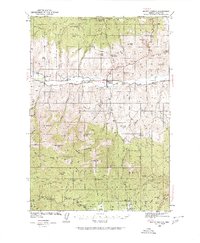 1940 Mount Vernon1959 Print · USGSMount Vernon and the John Day River valley are shown here just before mid-century, capturing a landscape of remote ranches and forest lookouts. Genealogists can locate family landmarks like Fletcher Ranch, Belshaw Sch, and the Cinnabar Mine.2 unique versions available
 - 1940 Map of Aldrich Mtn., 1960 Print
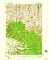 1940 Aldrich Mtn.1960 Print · USGSGrant County ranching and timber management are captured here just before the mid-century, following the winding John Day River. You can trace early 20th-century family history through the Mountain View Sch and various homesteads like Clark Ranch and Weaver Cabin.2 unique versions available
 - 1940 Map of John Day, 1960 Print
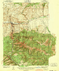
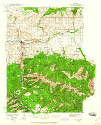 1940 John Day1960 Print · USGSGrant County is captured here at the end of the 1930s as a region defined by high-desert ranching and the remnants of a gold-mining boom. Genealogists can trace early landmarks like Canyon City, the Joaquin Miller Resort, and several abandoned workings such as the Iron King Mine.2 unique versions available
 - 1943 Map of Aldrich Mtn.
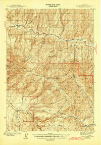 1943 Aldrich Mtn.1943 Print · USGSGrant County ranching and mining life are detailed here in the early 1940s, showing a remote landscape connected by river crossings and mountain trails. Researchers can locate family landmarks like the Aldrich Grave, Black Ranch, and the Oregon Mine.2 unique versions available
 - 1943 Map of John Day
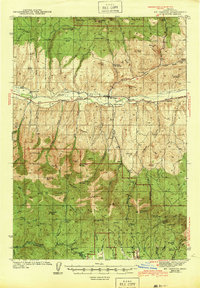
 1943 John Day1943 Print · USGSGrant County is captured during the early 1940s, showing the intersection of ranching and the waning mining era near Canyon City. Genealogists and historians can locate family landmarks like the Kuhl Ranch or trace the history of the Golden West Mine (abandoned) and Marysville Sch.2 unique versions available
 - 1943 Map of Mount Vernon
 1943 Mount Vernon1943 Print · USGSMount Vernon and the surrounding Grant County highlands are seen here during the early 1940s as a hub for ranching and mercury mining. Genealogists and historians can locate early homesteads and community centers like the Belshaw Sch, Koehler Ranch, and the Cinnabar Mine.
 - 1949 Map of Long Creek, 1959 Print
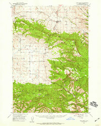 1949 Long Creek1959 Print · USGSGrant County is captured here in the late 1940s, showing a high-country landscape of timber and ranching before modern development. Genealogists and historians can locate old rural hubs like Round Basin School and trace industrial sites such as Fox Mill and the Cohoe Mine.2 unique versions available
 - 1949 Map of Susanville, 1966 Print
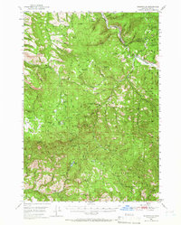 1949 Susanville1966 Print · USGSGrant County’s high country is captured here during the post-war era, showing the intersection of the Malheur National Forest and Whitman National Forest. Local historians can trace early wilderness infrastructure at Galena, the Hi Yu Guard Station, and isolated sites like Hamburger Cabin.
End of results
Showing maps 1-8 of 8
Top cities of Grant County
- John Day historical maps
- Prairie City historical maps
- Canyon City historical maps
- Mount Vernon historical maps
- Long Creek historical maps
- Seneca historical maps
See more
Frequently asked questions
- What are the different types of historical maps available for Grant County?
- What is the oldest map of Grant County?
- Where can I purchase historical maps of Grant County for my home or office?
- Where can I download high-res historical maps of Grant County?
- Are there historical topographic maps available for Grant County?
- Is there historical aerial imagery available for Grant County?
- Where are historical maps of Grant County sourced from?