1960s Maps of Harney County, Oregon
Explore 46 historic maps of Harney County from the 1960s. These maps offer a rare glimpse into what life looked like during the 1960s — showing old roads, neighborhoods, homes, and landmarks that have changed or disappeared over time.
Whether you're researching your family's past, planning a metal detecting trip, or studying how Harney County's landscape evolved across the 1960s, these high-resolution maps are a powerful tool for exploring the history of this region.
- Focus on a specific era: All maps on this page are from the 1960s, giving you a focused view of this time period.
- See what’s changed: Compare century-old streets, trails, and buildings to today's modern landscape using overlays and satellite layers.
- Research with precision: Use these maps for genealogy, historical research, land use analysis, or educational projects.
- View, download, or print: Maps are fully viewable online in high resolution, and can be downloaded or printed for your own records.
Start exploring Harney County's history through authentic maps from the 1960s. This is your window into the past.
Harney County, OR maps
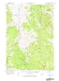
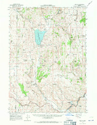
(46)- 1960 Map of Crane, 1962 Print
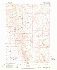
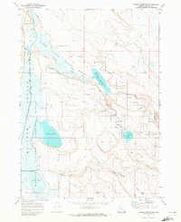
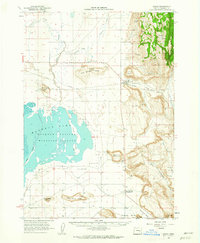 1960 Crane1962 Print · USGSHarney County's high desert landscape comes alive in the early sixties, showing the vital relationship between the Union Pacific rail line and the vast Malheur Lake basin. Genealogists and historians can trace the foundations of Crane and New Princeton, while locating landmarks like Kruger Field and the Hot Springs.2 unique versions available
 - 1960 Map of Burns, 1962 Print
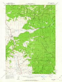
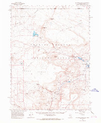
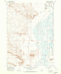
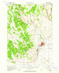 1960 Burns1962 Print · USGSHarney County's high desert hubs and surrounding cattle country are captured here just as the postwar era matured. Genealogists and local historians can locate family landmarks like the Peterson Ranch, trace the Northwestern Pacific rail line, or find early civic sites like the Union High Sch.
 - 1960 Map of Burns, 1962 Print
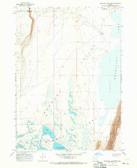
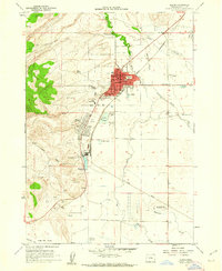 1960 Burns1962 Print · USGSThe Harney Basin communities of Burns and Hines are shown here in the early sixties at a peak of rail-driven and agricultural activity. Researchers can trace family history at the Burns Piute Cemetery or locate civic landmarks like the Grange Hall and the Experimental Station.2 unique versions available
 - 1961 Map of Delintment Lake, 1962 Print
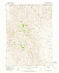
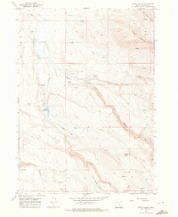
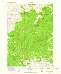 1961 Delintment Lake1962 Print · USGSHigh in the Ochoco Mountains during the early sixties, this area centered on Delintment Lake was a hub for forest management and back-country recreation. Researchers can locate remote sites like the Buck Spring Guard Sta, trace trails past Donnelly Butte, and find family-named landmarks like Williams Reservoir.2 unique versions available
 - 1961 Map of Calamity Butte, 1963 Print
 1961 Calamity Butte1963 Print · USGSHarney County's timber and mining country is captured here during the early sixties, featuring the working line of the Oregon and Northwestern Railroad. Genealogists and historians can trace the foundations of Idol City, the Lowe Mill site, and the remote Call Meadow Guard Sta.
 - 1961 Map of Trident Peak, 1963 Print
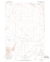
 1961 Trident Peak1963 Print · USGSThe Nevada-Oregon borderlands appear as a rugged ranching and mining frontier in the early sixties. Researchers can trace remote habitations and early industry at the Lucky Strike Mine, Kings River Ranch, and the Jack Spade Cabin ruins.2 unique versions available
 - 1961 Map of Logan Valley, 1963 Print
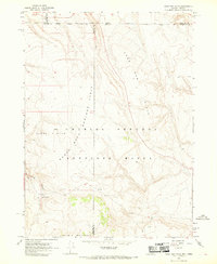
 1961 Logan Valley1963 Print · USGSLogan Valley was a hub of Oregon forest industry and high-country ranching during the early 1960s. Researchers can locate vanished landmarks like the Frost Mill (Site), the Lake Creek Guard Sta, and remote outposts such as Davenport Cabin.2 unique versions available
 - 1961 Map of Seneca, 1963 Print
 1961 Seneca1963 Print · USGSGrant County's timber and ranching country comes into focus in the early sixties, centered on the lumber town of Seneca. Genealogists and historians can trace family-named landmarks like Oliver Ranch and Charlie Smith Butte or the route of the Oregon Northwestern Railroad.2 unique versions available
 - 1961 Map of Disaster Peak, 1963 Print
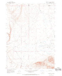
 1961 Disaster Peak1963 Print · USGSThe high desert of Humboldt County and the Oregon border comes into focus in the early sixties, showing a landscape of remote mines and cattle ranching. Trace old mining claims at the Moonlight Mine, locate high-country water at Yellow Rose Sprs, and find the remote Rio King Ranch.2 unique versions available
 - 1962 Map of Vya
 1962 Vya1962 Print · USGSThe Nevada and Oregon borderlands in the early sixties reveal a landscape of isolated ranching outposts and high-desert mining. Researchers can trace historic family holdings like the Denio Ranch or locate early mineral sites including the Mcadoo Mine and Iron King Mine.
 - 1962 Map of Adel, 1963 Print
 1962 Adel1963 Print · USGSSoutheastern Oregon in the early sixties reveals a landscape of massive basins, remote ranches, and expansive wildlife refuges. Researchers can locate vanished rural infrastructure like the Trout Creek School or trace early routes through Adel and Frenchglen.
 - 1965 Map of Railroad Point, 1967 Print
 1965 Railroad Point1967 Print · USGSNorthwestern Nevada at the Oregon border was a land of remote ranches and geothermal springs in the mid-1960s. Genealogists and desert historians can trace the foundations of Thousand Creek Ranch, the Painted Hills Mine, and Bog Hot Springs.2 unique versions available
 - 1966 Map of Bluejoint Lake East, 1968 Print
 1966 Bluejoint Lake East1968 Print · USGSIn the mid-1960s, the high desert of south-central Oregon was a landscape of remote ridges and vital wildlife territory. Trace the rugged terrain of Poker Jim Ridge and the Hart Mountain National Antelope Refuge, including water sources at Bluejoint Lake.
 - 1966 Map of Denio, 1968 Print
 1966 Denio1968 Print · USGSThe high desert borderlands near Denio are captured here in the late sixties, where the Pueblo Mountains meet the Oregon Nevada state line. Researchers can trace early ranching and transport history through sites like the Bramlett Stage Sta and the Howard Cem.2 unique versions available
 - 1966 Map of Big Spring Butte, 1968 Print
 1966 Big Spring Butte1968 Print · USGSThe high desert of Humboldt County and the Oregon border are captured in the late sixties, highlighting the remote operations of the Charles Sheldon Antelope Range. Researchers can trace old mining claims at the Virgin Mine and Rainbow Ridge Mine or find early camp sites like McKenney Camp.2 unique versions available
 - 1966 Map of Rabbit Hills NE, 1969 Print
 1966 Rabbit Hills NE1969 Print · USGSThe Oregon high desert north of Plush is captured here in the mid-1960s, showcasing a landscape defined by mineral interests and rangeland. Trace the boundaries of the Sunstone Area and follow the course of Rabbit Creek through Rabbit Basin.2 unique versions available
 - 1966 Map of Rabbit Hills NW, 1969 Print
 1966 Rabbit Hills NW1969 Print · USGSSouthern Oregon's high-desert ranching country is captured here in the mid-1960s, showing the intersection of Lake and Harney counties. You can trace the remote network of Hogback Road and Jeep Trails to isolated points like the M C Corral and Foley.2 unique versions available
 - 1966 Map of Sage Hen Hills, 1969 Print
 1966 Sage Hen Hills1969 Print · USGSThe high desert at the Nevada-Oregon border comes into focus in the mid-1960s, showing the remote wildlife lands of the Charles Sheldon Antelope Range. Trace isolated water sources like Rock Spring and early access routes along the Jeep Trail.2 unique versions available
 - 1966 Map of Beulah, 1971 Print
 1966 Beulah1971 Print · USGSThe high desert of Malheur County comes alive in this mid-century survey, centered on the Beulah Reservoir and the North Fork Malheur River. Researchers can trace early infrastructure and local genealogy through landmarks like Agency Valley Cem, the Agency Valley Dam, and the Old Indian Treaty Boundary.2 unique versions available
 - 1967 Map of Bluejoint Lake West, 1969 Print
 1967 Bluejoint Lake West1969 Print · USGSWarner Valley in the late sixties shows a remote landscape of alkaline basins and steep rimrock. Genealogists and historians can trace the remote Bluejoint Ranch and the boundary of the Hart Mtn National Antelope Refuge near Stone Corral Lake.2 unique versions available
 - 1967 Map of Coyote Buttes, 1972 Print
 1967 Coyote Buttes1972 Print · USGSThe high desert of Harney County in the late sixties reveals a landscape of wildlife conservation and arid basin topography. Researchers can trace the water management of the Malheur National Wildlife Refuge and locate specific sites like the Malheur Job Corps Conservation Center and Saddle Butte.2 unique versions available
 - 1967 Map of Happy Valley, 1972 Print
 1967 Happy Valley1972 Print · USGSHarney County ranching and high-desert terrain come into focus in the late sixties. Genealogists and historians can trace family-named sites like Smyth Ranch, find the Smyth Cem, and locate ancient Pictographs near Riddle Creek.2 unique versions available
 - 1967 Map of Krumbo Reservoir, 1972 Print
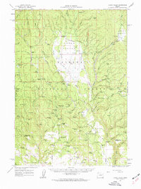
 1967 Krumbo Reservoir1972 Print · USGSThe Malheur National Wildlife Refuge and the Blitzen Valley are seen here in the late sixties, showing a landscape defined by water conservation. Researchers can trace the ranching and water infrastructure of Harney County at Witzel Ranch, Krumbo Reservoir, and Baca Lake.2 unique versions available
 - 1967 Map of Jackass Butte, 1972 Print
 1967 Jackass Butte1972 Print · USGSHarney County's high-desert ranching and wildlife landscapes are captured here in the late sixties. Researchers can trace the water management of the Buena Vista Canal or locate remote sites like Juniper Park Ranch and the Corral near Jackass Butte.
 - 1967 Map of Jackass Butte NE, 1972 Print
 1967 Jackass Butte NE1972 Print · USGSHarney County's high desert meets the Malheur wetlands in the late sixties, where volcanic fields and river systems converge. Researchers can trace the path of the Donner und Blitzen River past Dunn Dam or explore the geologically significant Diamond Craters.2 unique versions available
Showing maps 1-25 of 46
Top cities of Harney County
Frequently asked questions
- What are the different types of historical maps available for Harney County?
- What is the oldest map of Harney County?
- Where can I purchase historical maps of Harney County for my home or office?
- Where can I download high-res historical maps of Harney County?
- Are there historical topographic maps available for Harney County?
- Is there historical aerial imagery available for Harney County?
- Where are historical maps of Harney County sourced from?