1990s Maps of Harney County, Oregon
Explore 98 historic maps of Harney County from the 1990s. These maps offer a rare glimpse into what life looked like during the 1990s — showing old roads, neighborhoods, homes, and landmarks that have changed or disappeared over time.
Whether you're researching your family's past, planning a metal detecting trip, or studying how Harney County's landscape evolved across the 1990s, these high-resolution maps are a powerful tool for exploring the history of this region.
- Focus on a specific era: All maps on this page are from the 1990s, giving you a focused view of this time period.
- See what’s changed: Compare century-old streets, trails, and buildings to today's modern landscape using overlays and satellite layers.
- Research with precision: Use these maps for genealogy, historical research, land use analysis, or educational projects.
- View, download, or print: Maps are fully viewable online in high resolution, and can be downloaded or printed for your own records.
Start exploring Harney County's history through authentic maps from the 1990s. This is your window into the past.
Harney County, OR maps
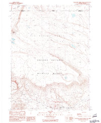
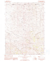
(98)- 1990 Map of Big Mowich Mountain
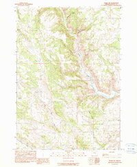
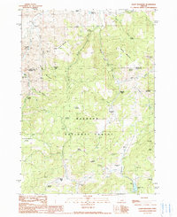
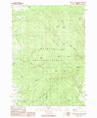
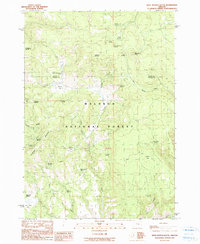
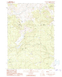 1990 Big Mowich Mountain1990 Print · USGSHarney and Grant counties meet in this 1990 survey of the high forest country before modern digital mapping changed the look of the landscape. Researchers can trace family-named sites like Harris Ranch or Allison Ranch and locate remote landmarks such as the Allison Guard Sta and Stinking Spring.
 - 1990 Map of Ninemile Slough
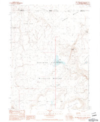
 1990 Ninemile Slough1990 Print · USGSThe high desert of eastern Oregon's basin country comes into focus in the early nineties, revealing a landscape of water management and cattle ranching. Researchers can trace the winding course of Ninemile Slough and locate dozens of infrastructure features like Check Dams and a prominent Spoil Bank.
 - 1990 Map of Poison Creek
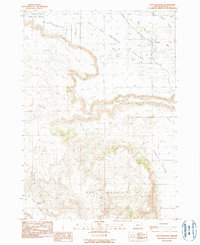
 1990 Poison Creek1990 Print · USGSHarney County's high-desert ranching country is captured here during the late twentieth century, showing the intricate water systems and remote homesteads. Researchers can trace land use at Thousand Spring Ranch or locate the Poison Creek (Site) and Fivemile Dam.
 - 1990 Map of Calamity Butte
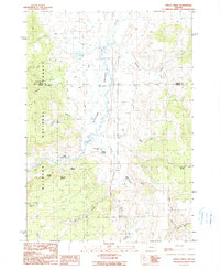
 1990 Calamity Butte1990 Print · USGSHarney County's high forest and ranching country is captured here in the late twentieth century. Genealogists and local historians can trace family-named sites and remote outposts such as Wade Ranch, Jackknife Flat, and Calamity Butte.
 - 1990 Map of Burns NW
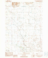
 1990 Burns NW1990 Print · USGSHarney County's high desert ranching landscape is captured here in the late twentieth century. Researchers can trace vital water sources and land divisions along the Silvies River, Skull Creek Reservoir, and family-named landmarks like Boone Canyon.
 - 1990 Map of Bear Canyon Butte
 1990 Bear Canyon Butte1990 Print · USGSHarney County's high-elevation timberlands are captured here in the early nineties, where the borders of two national forests meet. Researchers can locate remote landmarks like Corbett Cabin and several named water sources such as Dipping Vat Spring and Lost Guard Spring.
 - 1990 Map of Harney
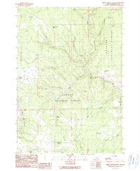
 1990 Harney1990 Print · USGSHarney Valley and the timbered fringes of the Malheur National Forest are captured here during the late twentieth century. Genealogists and local historians can pinpoint the Fort Harney (Site) and the settlement of Harney at the base of Mortimer Canyon.
 - 1990 Map of Crane
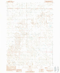
 1990 Crane1990 Print · USGSHigh-desert ranching and water resources define the Crane area in the late 1980s. Genealogists and researchers can trace local landmarks like Krueger Field, the Crane Butte volcanic rises, and the waters of Temple Spring.
 - 1990 Map of Alsup Mountain
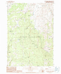
 1990 Alsup Mountain1990 Print · USGSHarney and Grant counties meet in this high-altitude forest landscape during the late twentieth century. Researchers can locate numerous historical footprints including the Carey Ranch (Site), Buttes Ranch (Site), and the Bear Tree Guard Sta (Site).
 - 1990 Map of Devine Ridge North
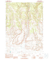
 1990 Devine Ridge North1990 Print · USGSHarney County's high ridges and ranching history are preserved in this 1990 survey of the Malheur National Forest. Researchers can trace old family holdings at Purdy Ranch and Hardesty Ranch, or locate the historic Summit (Site) near Fuqua Flat.
 - 1990 Map of The Narrows
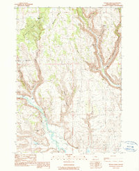
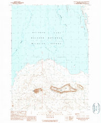
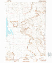
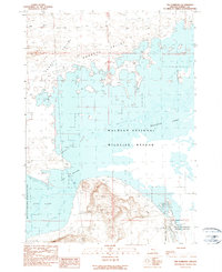 1990 The Narrows1990 Print · USGSHigh desert wetlands and lake basins define this part of Harney County in the early 1990s. Researchers can trace the water levels and canals through the Malheur National Wildlife Refuge, noting land features like The Narrows and Loma.
 - 1990 Map of Redess
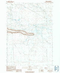 1990 Redess1990 Print · USGSHarney County's high desert ranching landscape is captured here in the mid-1980s, centered on the complex drainage of the Silvies River. Genealogists and local historians can locate the Redess (Site), the Sunset Valley Cem, and the prominent Wrights Point.
 - 1990 Map of Thousand Creek Spring
 1990 Thousand Creek Spring1990 Print · USGSThe high desert borderlands of Nevada and Oregon come into focus during the late twentieth century, showing a landscape defined by wildlife preservation and volcanic plateaus. Researchers can locate remote outposts like McKenney Camp and important water sources such as Thousand Creek Spring and Dufurrena Pond No 19.
 - 1990 Map of Malheur Lake East
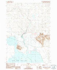
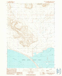
 1990 Malheur Lake East1990 Print · USGSThe high-desert wetlands of Harney County are captured in the late twentieth century as they border the Harney Valley. Trace the shifting shorelines of Malheur Lake and identify land features like Black Butte and Pelican Island.
 - 1990 Map of Poison Creek Slough
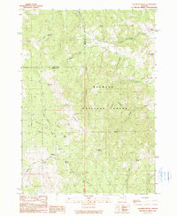
 1990 Poison Creek Slough1990 Print · USGSThe Harney Valley landscape near the close of the century reveals a complex irrigation and aviation hub. Researchers can trace the winding Silvies River and its many sloughs, or locate landmarks like the Burns Municipal Airport and Sand Hill.
 - 1990 Map of Warm Springs Butte
 1990 Warm Springs Butte1990 Print · USGSHarney County's high desert wetlands and volcanic landmarks are captured here in the late twentieth century. Researchers can trace the perimeter of the Malheur National Wildlife Refuge and locate remote sites like Saddle Butte Cem and Hot Springs.
 - 1990 Map of Dog Mountain
 1990 Dog Mountain1990 Print · USGSHarney County in the late eighties and early nineties reveals a complex landscape of desert valleys and high-plateau landmarks. Researchers can trace water management along the Silvies River or locate remote water sources like Lunch Lake and Weaver Spring.
 - 1990 Map of Big Spring Butte
 1990 Big Spring Butte1990 Print · USGSThe Nevada-Oregon borderlands are captured here in the 1990s within the protected expanse of the Sheldon National Wildlife Refuge. Researchers can trace the high-desert hydrology of Big Spring Reservoir and family-named landmarks like Hazeltine Lake and Gooch Table.
 - 1990 Map of Trout Creek
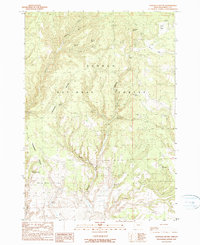
 1990 Trout Creek1990 Print · USGSHarney and Grant Counties are captured here in the late twentieth century, showing the ranching heart of the high desert. Genealogists and researchers can trace local landholdings like Silvies Valley Ranch and Purdy Ranch or locate family-named landmarks like Maitland Spring.
 - 1990 Map of Jump-Off Joe Mountain
 1990 Jump-Off Joe Mountain1990 Print · USGSThe high backcountry of the Blue Mountains comes alive in this late twentieth-century survey of the Malheur National Forest boundary. Researchers can trace dozens of vital water sources and landmarks, including Jump-off Joe Mountain, Wolf Creek Meadow, and the family-named John S Spring.
 - 1990 Map of Trident Peak
 1990 Trident Peak1990 Print · USGSThe Nevada-Oregon borderlands in the 1990s reveal a landscape of high summits and isolated mining outposts. Researchers can trace remote history through the Lucky Strike Mine and family-named ruins like the Jack Spade Cabin and Ayers Cabin.
 - 1990 Map of Donnelly Butte
 1990 Donnelly Butte1990 Print · USGSHarney County's high forest and prairie lands are captured here in the late twentieth century, showing a landscape defined by vital water sources. Researchers can trace the drainages of Silver Creek and locate remote landmarks like Donnelly Butte and Duffy Prairie.
 - 1990 Map of New Princeton
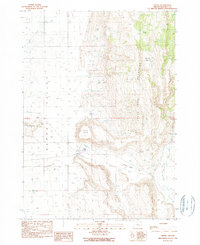
 1990 New Princeton1990 Print · USGSHarney County's high desert landscape is captured here in the late twentieth century, centered on the Harney Valley floor. Genealogists and local historians can locate New Princeton and the Windy Point Cem near the base of Windy Point.
 - 1990 Map of Northeast Harney Lake
 1990 Northeast Harney Lake1990 Print · USGSHarney County's high desert landscape appears as a complex of shifting sands and seasonal waters in the 1980s. Naturalists and researchers can trace the edges of the Malheur National Wildlife Refuge from Dog Mountain to the shores of Harney Lake.
 - 1990 Map of West Myrtle Butte
 1990 West Myrtle Butte1990 Print · USGSThe Oregon backcountry of Grant and Harney counties is captured here in the early nineties, centered on the high timber and meadows of the Malheur National Forest. Researchers can trace the drainages of West Myrtle Creek and locate remote landmarks like Sallys Flat and Sugarloaf Mountain.
Showing maps 1-25 of 98
Top cities of Harney County
Frequently asked questions
- What are the different types of historical maps available for Harney County?
- What is the oldest map of Harney County?
- Where can I purchase historical maps of Harney County for my home or office?
- Where can I download high-res historical maps of Harney County?
- Are there historical topographic maps available for Harney County?
- Is there historical aerial imagery available for Harney County?
- Where are historical maps of Harney County sourced from?