1920s Maps of Jefferson County, Oregon
Explore 6 historic maps of Jefferson County from the 1920s. These maps offer a rare glimpse into what life looked like during the 1920s — showing old roads, neighborhoods, homes, and landmarks that have changed or disappeared over time.
Whether you're researching your family's past, planning a metal detecting trip, or studying how Jefferson County's landscape evolved across the 1920s, these high-resolution maps are a powerful tool for exploring the history of this region.
- Focus on a specific era: All maps on this page are from the 1920s, giving you a focused view of this time period.
- See what’s changed: Compare century-old streets, trails, and buildings to today's modern landscape using overlays and satellite layers.
- Research with precision: Use these maps for genealogy, historical research, land use analysis, or educational projects.
- View, download, or print: Maps are fully viewable online in high resolution, and can be downloaded or printed for your own records.
Start exploring Jefferson County's history through authentic maps from the 1920s. This is your window into the past.
Jefferson County, OR maps
(6)- 1926 Map of Mitchell
 1926 Mitchell1926 Print · USGSCentral Oregon ranching and geology are documented here in the mid-1920s, showing a landscape defined by the winding John River. Genealogists can locate family holdings like Old Frizzell Ranch and Laird Ranch alongside remote schoolhouses like Gable School.3 unique versions available
 - 1926 Map of Bend, 1963 Print
 1926 Bend1963 Print · USGSCentral Oregon in the mid-1920s was a landscape of emerging irrigation districts and busy timber rails centered around the growing hub of Bend. Researchers can trace early rural life through family-named landmarks like Gales Ranch and numerous country schoolhouses including Young Sch and Pine Ridge Sch.
 - 1927 Map of Mt. Jefferson, 1956 Print
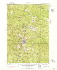 1927 Mt. Jefferson1956 Print · USGSThe Oregon Cascades in the late twenties were defined by high-altitude trails and the early management of the Santiam and Mount Hood forests. Trace the historic Skyline Trail past remote outposts like Lemiti Ranger Sta and the Breitenbush Hot Sprs.2 unique versions available
 - 1928 Map of Madras, 1956 Print
 1928 Madras1956 Print · USGSJefferson County was a landscape of high plateaus and deep river canyons in the late twenties, where new highways met tribal lands. Genealogists can trace family footprints at Hebe Mill, Simnasho, and rural schoolhouses like Mountain View Sch.
 - 1929 Map of Bend
 1929 Bend1929 Print · USGSCentral Oregon in the late twenties shows a landscape shaped by irrigation and the expansion of the rail lines. Genealogists can locate family-named sites like Gates Ranch and numerous rural schoolhouses including Arnold Sch and Lava Rock Sch.5 unique versions available
 - 1929 Map of Three Sisters, 1956 Print
 1929 Three Sisters1956 Print · USGSThe High Cascades meet the Deschutes plateau in the late 1920s, a time when fire lookouts and cow camps dotted the volcanic peaks. Genealogists and historians can trace the early footprints of Sisters, Camp Sherman, and the historic Old Toll Station.2 unique versions available
End of results
Showing maps 1-6 of 6
Top cities of Jefferson County
Frequently asked questions
- What are the different types of historical maps available for Jefferson County?
- What is the oldest map of Jefferson County?
- Where can I purchase historical maps of Jefferson County for my home or office?
- Where can I download high-res historical maps of Jefferson County?
- Are there historical topographic maps available for Jefferson County?
- Is there historical aerial imagery available for Jefferson County?
- Where are historical maps of Jefferson County sourced from?