1960s Maps of Jefferson County, Oregon
Explore 34 historic maps of Jefferson County from the 1960s. These maps offer a rare glimpse into what life looked like during the 1960s — showing old roads, neighborhoods, homes, and landmarks that have changed or disappeared over time.
Whether you're researching your family's past, planning a metal detecting trip, or studying how Jefferson County's landscape evolved across the 1960s, these high-resolution maps are a powerful tool for exploring the history of this region.
- Focus on a specific era: All maps on this page are from the 1960s, giving you a focused view of this time period.
- See what’s changed: Compare century-old streets, trails, and buildings to today's modern landscape using overlays and satellite layers.
- Research with precision: Use these maps for genealogy, historical research, land use analysis, or educational projects.
- View, download, or print: Maps are fully viewable online in high resolution, and can be downloaded or printed for your own records.
Start exploring Jefferson County's history through authentic maps from the 1960s. This is your window into the past.
Jefferson County, OR maps
(34)- 1961 Map of Whitewater River, 1963 Print
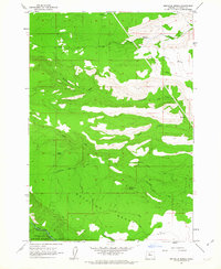
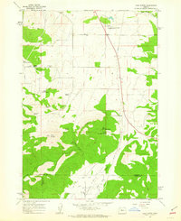
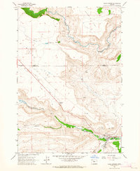
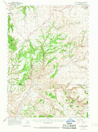
 1961 Whitewater River1963 Print · USGSJefferson County in the early sixties was a landscape of federal forest land and tribal reservation boundaries defined by the Metolius River. Researchers can locate specialized sites like the Fish Hatchery, the Camp Creek Ranger Sta, and the Alder Spring Lookout.2 unique versions available
 - 1961 Map of Fort Butte, 1963 Print
 1961 Fort Butte1963 Print · USGSThe high Cascades of Wasco and Jefferson counties are captured here in the early sixties, showing a landscape shaped by timber and range. Researchers can trace the drainage of Shitike Creek or locate local landmarks like Old Mill Camp and the Schoolie Pasture.2 unique versions available
 - 1961 Map of Mt. Jefferson, 1963 Print
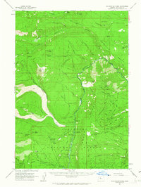
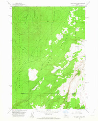
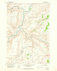
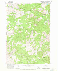
 1961 Mt. Jefferson1963 Print · USGSThe Oregon Cascades at the start of the 1960s were a vast network of backcountry trails and forest service outposts. You can trace the historic Skyline Trail through the Warm Springs Indian Reservation or locate the remote John Swallow Grave and Pamelia Lake Guard Sta.3 unique versions available
 - 1961 Map of Breitenbush Hot Springs, 1964 Print
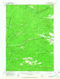
 1961 Breitenbush Hot Springs1964 Print · USGSThe Oregon Cascades in the early 1960s are documented here during a period of active Forest Service management and recreational growth. Trace the development of Breitenbush Hot Springs or locate remote landmarks like the Rho Ridge Shelter and the Clackamas Ranger Sta.3 unique versions available
 - 1962 Map of Metolius Bench, 1963 Print
 1962 Metolius Bench1963 Print · USGSJefferson County’s high volcanic plateaus meet the river canyons in the early 1960s. Outdoor enthusiasts and local historians can trace the old tracks to Drift Campground and Monty Campground or locate historic water sources like Beachkomb Spring.3 unique versions available
 - 1962 Map of Opal City, 1963 Print
 1962 Opal City1963 Print · USGSCentral Oregon's high desert landscape and vital irrigation systems are documented here during the early sixties. Researchers can trace the path of the Crooked River and the development of the Oregon Trunk railway near Opal City and Peter Skene Ogden State Park.2 unique versions available
 - 1962 Map of Fly Creek, 1963 Print
 1962 Fly Creek1963 Print · USGSJefferson County’s high desert canyons and timberlands are captured here during the early 1960s as a new reservoir system begins to transform the landscape. Researchers can trace the early footprint of Lake Chinook or locate remote sites like Fly Creek Ranch and Fly Lake Lookout.2 unique versions available
 - 1962 Map of Squaw Back Ridge, 1963 Print
 1962 Squaw Back Ridge1963 Print · USGSJefferson and Deschutes counties in the early 1960s reveal a landscape of remote ranches and high-desert canyons. Genealogists and local historians can locate the Geneva (Site) or trace family landmarks like the Squaw Flat Ranch and Rim Rock Ranch.2 unique versions available
 - 1962 Map of Gray Butte, 1963 Print
 1962 Gray Butte1963 Print · USGSJefferson County ranching and water management are mapped in the early sixties as irrigation reaches the high desert. Local researchers can trace family-named water sources like Rodman Spring and visit the site of the Lone Pine Sch or Gray Butte Cem.2 unique versions available
 - 1962 Map of Prineville, 1964 Print
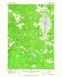
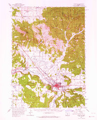 1962 Prineville1964 Print · USGSCentral Oregon in the early 1960s shows a landscape of river-valley agriculture and rugged uplands centering on the growing city of Prineville. Genealogists and local historians can trace rural infrastructure from Lamonta to the Upper McKay Sch and the various Cinder Pits dotting the volcanic buttes.2 unique versions available
 - 1962 Map of Eagle Butte, 1964 Print
 1962 Eagle Butte1964 Print · USGSThe Warm Springs Indian Reservation and Agency Plains meet in the early 1960s at the confluence of the Deschutes and Warm Springs rivers. Trace local development and genealogy through the Dry Creek Cem, the Lumber Mill, and the riverside site of Mecca.
 - 1962 Map of Steelhead Falls, 1964 Print
 1962 Steelhead Falls1964 Print · USGSHigh desert canyons and river confluences define this central Oregon landscape in the early sixties. Researchers can trace ranching footprints and water development near Grandview, the Lower Bridge Sch (Aban'd), and Steelhead Falls.2 unique versions available
 - 1962 Map of Seekseequa Junction, 1964 Print
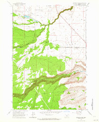
 1962 Seekseequa Junction1964 Print · USGSJefferson County plateau lands meet the canyon waters of the Deschutes in the early sixties. Researchers can trace the development of Lake Simtustus and locate remote landmarks like Seekseequa Junction and local cemeteries.
 - 1962 Map of Gateway, 1964 Print
 1962 Gateway1964 Print · USGSJefferson County ranchlands and river canyons are captured here in the early sixties, showing the vital rail and water networks of the high desert. Researchers can trace the paths of the Oregon Trunk railroad through Old Maids Canyon and locate the small settlement of Gateway.4 unique versions available
 - 1962 Map of Round Butte Dam, 1964 Print
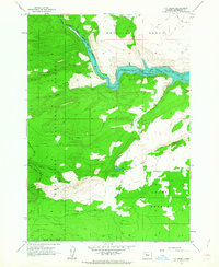
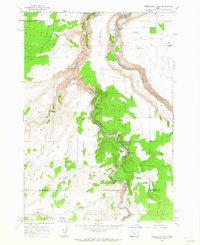
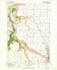
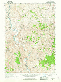
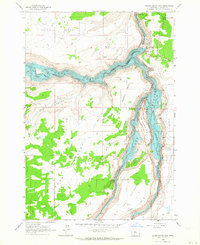 1962 Round Butte Dam1964 Print · USGSJefferson County's river canyons were undergoing a massive transformation in the early sixties as new hydroelectric projects reshaped the Deschutes basin. Researchers can trace the submerged contours of the Chinook River and the former location of Grandview (Site) on the canyon rim.2 unique versions available
 - 1963 Map of Culver, 1964 Print
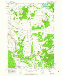
 1963 Culver1964 Print · USGSJefferson County farming and rail life are centered here in the early sixties. Researchers can trace ancestral roots at the German Cemetery, locate the old railroad line, and find local landmarks like the Drive-in Theater near Madras.
 - 1963 Map of Potters Ponds, 1964 Print
 1963 Potters Ponds1964 Print · USGSJefferson and Wasco Counties were primarily high-desert rangeland in the early sixties, defined by remote corrals and seasonal water sources. Trace historical land use through landmarks like Sidwalter Corral, Potters Ponds, and the winding Old Mill Road.2 unique versions available
 - 1963 Map of Warm Springs, 1964 Print
 1963 Warm Springs1964 Print · USGSThe Warm Springs Reservation in the early sixties shows a landscape defined by plateau flats and deep creek canyons. Researchers can locate the Bruno Cem, trace the route of Tenino Road, and identify the mid-century layout of the Rodeo Grounds and Warm Springs settlement.2 unique versions available
 - 1963 Map of Madras West, 1964 Print
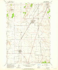
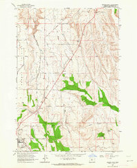
 1963 Madras West1964 Print · USGSJefferson County in the early 1960s shows a landscape of dramatic river canyons and irrigation expansion. Trace family history at the Milo Gard Cem or explore the rail line at Madras Sta and the massive Pelton Dam.3 unique versions available
 - 1963 Map of Madras East, 1964 Print
 1963 Madras East1964 Print · USGSJefferson County in the early 1960s reveals a transition from open range to organized agriculture and transit. Genealogists and local historians can trace family-named sites like Schmoker Spring and Kutcher Well or the rail path of the Oregon Trunk.2 unique versions available
 - 1963 Map of Buck Butte, 1964 Print
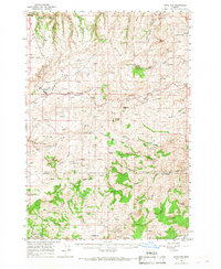
 1963 Buck Butte1964 Print · USGSJefferson County ranching life is well-documented in the early sixties, showing a landscape defined by water rights and remote outposts. Genealogists and local historians can trace family-named sites like Dayton-Grant Well and Boyce Corral near the heights of Buck Butte.
 - 1966 Map of Antelope, 1968 Print
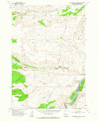
 1966 Antelope1968 Print · USGSIn the mid-1960s, the high plateau of Central Oregon supported a mix of ranching and mining near the settlements of Shaniko and Antelope. Researchers can trace the mineral history of the region at the Oregon King Mine or locate early family markers at the Cemetery and Sorefoot Ranch.
 - 1966 Map of Willowdale, 1968 Print
 1966 Willowdale1968 Print · USGSThe high desert border of Wasco and Jefferson counties comes into focus here during the mid-1960s. Researchers can trace remote ranching outposts like Rooper Ranch, find the Maupin Cemetery, and explore landmarks such as Friends Peak and Willowdale.
 - 1966 Map of Clarno, 1969 Print
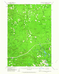
 1966 Clarno1969 Print · USGSThe John Day River corridor in the mid-1960s reveals a landscape of remote ranching outposts and geological landmarks. Researchers can trace family history through sites like Tillotson Cem, the Lower Pine Creek Sch, and the Knox Ranch.
 - 1968 Map of Horse Heaven Creek, 1971 Print
 1968 Horse Heaven Creek1971 Print · USGSJefferson County’s high-desert uplands are captured in the late sixties, showing a landscape of mercury mining and rugged ranching terrain. Genealogists and historians can locate the Horse Heaven Mine and trace water sources like Buttercup Spring or Mays Reservoir among the buttes.2 unique versions available
Showing maps 1-25 of 34
Top cities of Jefferson County
Frequently asked questions
- What are the different types of historical maps available for Jefferson County?
- What is the oldest map of Jefferson County?
- Where can I purchase historical maps of Jefferson County for my home or office?
- Where can I download high-res historical maps of Jefferson County?
- Are there historical topographic maps available for Jefferson County?
- Is there historical aerial imagery available for Jefferson County?
- Where are historical maps of Jefferson County sourced from?