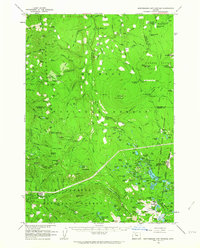
1961 Map of Breitenbush Hot Springs
USGS Topo · Published 1964About this map
Breitenbush Hot Springs serves as a primary point of interest in this 1961 survey, documenting the developed thermal area and its surrounding forest infrastructure. This high-altitude landscape is characterized by a dense network of US Forest Service facilities, including the Clackamas Ranger Sta, the Rho Ridge Shelter, and multiple guard stations positioned along the boundary between the Mount Hood National Forest and Willamette National Forest.
Find a feature on this map
156 named features on this map. Tap any name to fly to it.
Don’t see what you’re looking for? This feature index may not catch every label — zoom into the map to look around manually.
Map Details
Editions of this 1961 Breitenbush Hot Springs Map
3 editions found
Other maps of this area

1916 · Estacada
USGS Topo · 1:125,000

1924 · Mount Hood
USGS Topo · 1:125,000

1927 · Mount Hood
USGS Topo · 1:125,000

1927 · Mt. Jefferson
USGS Topo · 1:125,000

1929 · Mill City
USGS Topo · 1:125,000

1930 · Mt. Jefferson
USGS Topo · 1:125,000

1948 · Vancouver
USGS Topo · 1:250,000

1950 · Vancouver
USGS Topo · 1:250,000

1950 · Vancouver
USGS Topo · 1:250,000

1953 · Salem
USGS Topo · 1:250,000