1970s Maps of Lincoln County, Oregon
Explore 5 historic maps of Lincoln County from the 1970s. These maps offer a rare glimpse into what life looked like during the 1970s — showing old roads, neighborhoods, homes, and landmarks that have changed or disappeared over time.
Whether you're researching your family's past, planning a metal detecting trip, or studying how Lincoln County's landscape evolved across the 1970s, these high-resolution maps are a powerful tool for exploring the history of this region.
- Focus on a specific era: All maps on this page are from the 1970s, giving you a focused view of this time period.
- See what’s changed: Compare century-old streets, trails, and buildings to today's modern landscape using overlays and satellite layers.
- Research with precision: Use these maps for genealogy, historical research, land use analysis, or educational projects.
- View, download, or print: Maps are fully viewable online in high resolution, and can be downloaded or printed for your own records.
Start exploring Lincoln County's history through authentic maps from the 1970s. This is your window into the past.
Lincoln County, OR maps
(5)- 1974 Map of Warnicke Creek, 1976 Print
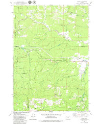
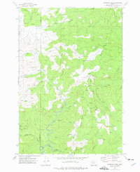 1974 Warnicke Creek1976 Print · USGSThe rugged timberlands along the Polk and Lincoln county line are captured here in the mid-seventies. Researchers can trace logging access via Murphy Road and locate landmarks like Rooster Rock, Sugarloaf Mountain, and Stott Mtn.
 - 1974 Map of Valsetz, 1977 Print
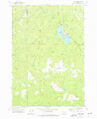 1974 Valsetz1977 Print · USGSIn the mid-seventies, the timber town of Valsetz remained a focal point of Oregon's Coast Range before its eventual removal. Researchers can trace the layout of the town and locate the former locations of Western Camp and the Fish Ladder along the Siletz River.
 - 1975 Map of Yaquina SE, 1979 Print
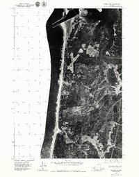 1975 Yaquina SE1979 Print · USGSThe Oregon coast in the mid-1970s reveals a landscape of dense timber and tidal estuaries just south of the harbor entrance. Researchers can trace the development of Southbeach and study the original banks of the Yaquina River before decades of modern change.
 - 1975 Map of Yaquina NE, 1979 Print
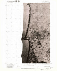 1975 Yaquina NE1979 Print · USGSThe Oregon coast in the mid-seventies reveals the early growth of Newport and the natural landmarks of the shoreline. Researchers can trace the path of Highway 101 as it passes through Agate Beach toward the iconic Devils Punch Bowl.2 unique versions available
 - 1979 Map of Midway
 1979 Midway1979 Print · USGSCoastal mountains and timberlands meet in the late seventies where Yamhill, Tillamook, Lincoln, and Polk counties converge. Researchers can locate the Church in the Wildwood, trace the Nestucca River, and find small settlements like Midway and Boyer.
End of results
Showing maps 1-5 of 5
Top cities of Lincoln County
- Newport historical maps
- Lincoln City historical maps
- Toledo historical maps
- Waldport historical maps
- Depoe Bay historical maps
- Siletz historical maps
See more
Frequently asked questions
- What are the different types of historical maps available for Lincoln County?
- What is the oldest map of Lincoln County?
- Where can I purchase historical maps of Lincoln County for my home or office?
- Where can I download high-res historical maps of Lincoln County?
- Are there historical topographic maps available for Lincoln County?
- Is there historical aerial imagery available for Lincoln County?
- Where are historical maps of Lincoln County sourced from?