1910s Maps of Linn County, Oregon
Explore 13 historic maps of Linn County from the 1910s. These maps offer a rare glimpse into what life looked like during the 1910s — showing old roads, neighborhoods, homes, and landmarks that have changed or disappeared over time.
Whether you're researching your family's past, planning a metal detecting trip, or studying how Linn County's landscape evolved across the 1910s, these high-resolution maps are a powerful tool for exploring the history of this region.
- Focus on a specific era: All maps on this page are from the 1910s, giving you a focused view of this time period.
- See what’s changed: Compare century-old streets, trails, and buildings to today's modern landscape using overlays and satellite layers.
- Research with precision: Use these maps for genealogy, historical research, land use analysis, or educational projects.
- View, download, or print: Maps are fully viewable online in high resolution, and can be downloaded or printed for your own records.
Start exploring Linn County's history through authentic maps from the 1910s. This is your window into the past.
Linn County, OR maps
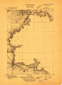
(13)- 1910 Map of Eugene
 1910 Eugene1910 Print · USGSThe upper Willamette Valley comes to life in the years before the Great War, centered on the growing campus of the University of Oregon. Genealogists can trace family footprints across dozens of local school districts like Santa Clara and Deadman, or follow the early tracks of the Oregon Electric RR.2 unique versions available
 - 1911 Map of Brownsville
 1911 Brownsville1911 Print · USGSBrownsville and the surrounding Linn County valley floor appear here during the early twentieth century. Genealogists and local historians can trace the early rail corridor of the Southern Pacific and locate rural landmarks like Rock Hill School and Warren School.
 - 1911 Map of Lebanon
 1911 Lebanon1911 Print · USGSLinn County agriculture and rail travel are in full bloom here in the decade before the First World War. Researchers can trace the early foundations of Lebanon or locate specific country schoolhouses like Gore School and Stoltz Hill School near the base of Peterson Butte.
 - 1911 Map of Tangent
 1911 Tangent1911 Print · USGSLinn County’s fertile valley was a hive of rail activity and rural education in the early twentieth century. Genealogists can locate family landmarks like Oak Creek Church and several rural schoolhouses, including Flunow School and Midway School.
 - 1912 Map of Jefferson
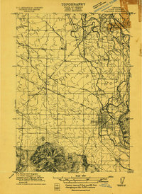
 1912 Jefferson1912 Print · USGSThe Willamette Valley at the height of the pre-war rail era shows a landscape of river-bend towns and rural school districts. Genealogists can locate family lands near Millersburg or trace the routes of the Oregon Electric and Corvallis and Eastern railroads.
 - 1912 Map of Halsey
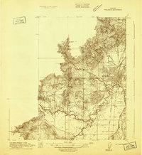
 1912 Halsey1912 Print · USGSThe Willamette Valley’s fertile floor and expanding rail networks are documented here just before the era of modern highways. Local historians can locate numerous vanished rural landmarks, from the Ingram Ferry crossing to schoolhouses like Bell Plain School and Harris School.3 unique versions available
 - 1913 Map of Philomath
 1913 Philomath1913 Print · USGSBenton County was a bustling hub of education and steam-era transport just before the First World War. Genealogists and rail historians can trace the early footprint of Oregon Agricultural College and the complex routes of the Corvallis and Eastern or find local burial sites like Newton Cem.
 - 1913 Map of Oakville
 1913 Oakville1913 Print · USGSThe Willamette Valley’s complex river system and early rail network come alive in this pre-World War I survey of the Linn and Benton county line. Genealogists and historians can trace defunct river crossings like Fisher Ferry and rural landmarks such as Oakville Sta and Dixie Sch.
 - 1913 Map of Wells
 1913 Wells1913 Print · USGSBenton and Polk counties are mapped here before the First World War, showing a Willamette Valley landscape defined by rail-stop settlements and riverside sloughs. Researchers can trace the development of Suver and Granger, or locate the historic State Game Farm and Suver Cem.
 - 1914 Map of Independence
 1914 Independence1914 Print · USGSIn the early twentieth century, the Willamette Valley was a bustling network of river landings and short-line railroads. Trace the routes of the Valley and Siletz RR or locate family sites like Highland School and Buena Vista along the river.
 - 1915 Map of Sidney
 1915 Sidney1915 Print · USGSMarion County's riverfront and rail corridors are captured here just before the First World War, showing a landscape of mills and tight-knit rural schools. Researchers can locate stops on the Oregon Electric line and local landmarks like Sidney Mills and Looney Butte.
 - 1916 Map of Albany
 1916 Albany1916 Print · USGSThe Willamette Valley thrives at a peak of rail and river activity in the early twentieth century. Genealogists and local historians can trace rural school districts like Dixie School, early river crossings such as Fisher Ferry, and the original paths of the Southern Pacific railroad.4 unique versions available
 - 1917 Map of Salem
 1917 Salem1917 Print · USGSThe Willamette Valley at the peak of its rail-and-river era shows a landscape of growing towns and specialized state institutions. Researchers can trace early family-named junctions and rural educational sites like Grabenhorst Corners, Keizer School, and Wigrich Landing.3 unique versions available
End of results
Showing maps 1-13 of 13
Top cities of Linn County
- Lebanon historical maps
- Sweet Home historical maps
- Harrisburg historical maps
- Brownsville historical maps
- Lyons historical maps
- Tangent historical maps
See more
Frequently asked questions
- What are the different types of historical maps available for Linn County?
- What is the oldest map of Linn County?
- Where can I purchase historical maps of Linn County for my home or office?
- Where can I download high-res historical maps of Linn County?
- Are there historical topographic maps available for Linn County?
- Is there historical aerial imagery available for Linn County?
- Where are historical maps of Linn County sourced from?