1980s Maps of Linn County, Oregon
Explore 51 historic maps of Linn County from the 1980s. These maps offer a rare glimpse into what life looked like during the 1980s — showing old roads, neighborhoods, homes, and landmarks that have changed or disappeared over time.
Whether you're researching your family's past, planning a metal detecting trip, or studying how Linn County's landscape evolved across the 1980s, these high-resolution maps are a powerful tool for exploring the history of this region.
- Focus on a specific era: All maps on this page are from the 1980s, giving you a focused view of this time period.
- See what’s changed: Compare century-old streets, trails, and buildings to today's modern landscape using overlays and satellite layers.
- Research with precision: Use these maps for genealogy, historical research, land use analysis, or educational projects.
- View, download, or print: Maps are fully viewable online in high resolution, and can be downloaded or printed for your own records.
Start exploring Linn County's history through authentic maps from the 1980s. This is your window into the past.
Linn County, OR maps
(51)- 1980 Map of Eugene
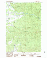
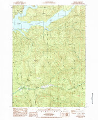
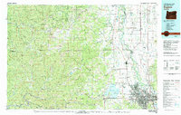 1980 Eugene1980 Print · USGSThe southern Willamette Valley and Coast Range are captured in the early eighties as the urban centers of Eugene and Springfield expanded. Researchers can trace the legacy of family estates and regional infrastructure through landmarks like Mahlon Sweet Airport, Fern Ridge Lake, and Junction City.
 - 1980 Map of Corvallis, 1981 Print
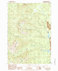
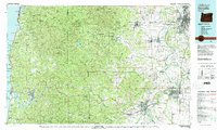 1980 Corvallis1981 Print · USGSThe Oregon Coast Range meets the fertile Willamette Valley in the early eighties, documenting a landscape of timber, agriculture, and growing college towns. Genealogists and historians can trace old rail lines like the Southern Pacific or locate landmarks like Marys Peak and the College of Education.
 - 1980 Map of Bend, 1993 Print
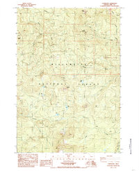
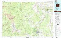 1980 Bend1993 Print · USGSCentral Oregon was evolving rapidly in the early eighties as outdoor recreation and transit hubs like Bend and Redmond expanded. Trace the historical footprints of Sisters, the Metolius River basin, and the Oregon Trunk Railway through the high desert.2 unique versions available
 - 1983 Map of Madras
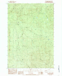
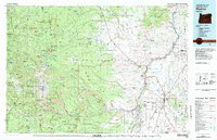 1983 Madras1983 Print · USGSJefferson County and the Warm Springs Indian Reservation are shown in detail during the early 1980s, from the Cascade peaks to the high desert. Researchers can trace the legacy of tribal lands at Simnasho, find the Abbot Cemetery, or follow the rail lines through Madras Sta.
 - 1983 Map of Mc Kenzie River, 1984 Print
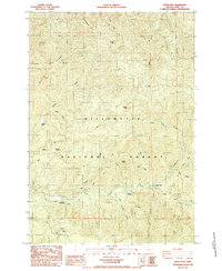
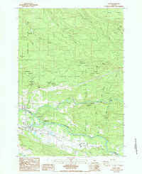
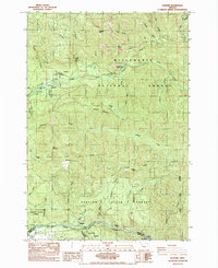
 1983 Mc Kenzie River1984 Print · USGSLinn and Lane Counties are shown in the early 1980s as a hub of hydroelectric power and timber production. Researchers can trace the development of river-valley towns like Sweet Home and Marcola or locate recreation sites at Foster Lake and Cougar Reservoir.
 - 1983 Map of North Santiam River, 1984 Print
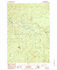
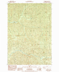
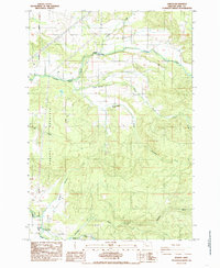
 1983 North Santiam River1984 Print · USGSThe western Cascades and Willamette Valley transition in the early eighties, from the state capital to the high timberlands. Genealogists and historians can trace rail lines like the Southern Pacific and explore communities from Mill City to Silver Falls City.
 - 1984 Map of Green Peter, 1985 Print
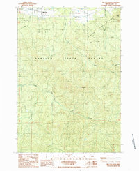
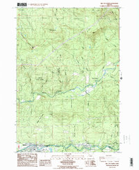
 1984 Green Peter1985 Print · USGSLinn County’s river valleys and timberlands are captured here in the mid-1980s as the regional economy balanced industry and recreation. Researchers can trace land use through features like Green Peter Dam, the local Cem, and Short Bridge.
 - 1984 Map of Harter Mtn, 1985 Print
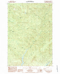
 1984 Harter Mtn1985 Print · USGSLinn County’s high Cascades are documented here in the mid-1980s, showcasing the intricate drainages of the Santiam River. Researchers can trace the Sevenmile Trail and locate sites like Tombstone Prairie, Cool Camp, and Tombstone Pass.
 - 1984 Map of Chimney Peak, 1985 Print
 1984 Chimney Peak1985 Print · USGSThe Linn County wilderness comes into focus in the early eighties, showcasing the heart of the Willamette National Forest. Trace remote landmarks and water features like the Mcquade Creek Shelter, Donaca Lake, and the falls along Egg Creek.
 - 1984 Map of Sweet Home, 1985 Print
 1984 Sweet Home1985 Print · USGSEastern Linn County comes into focus in the mid-1980s as a hub of timber and water management along the South Santiam River. Genealogists and historians can trace family sites like Gilland Cem and Lewis Cem or the layout of Berlin and Sweet Home.
 - 1984 Map of Lacomb, 1985 Print
 1984 Lacomb1985 Print · USGSLacomb and the surrounding Linn County foothills are captured here in the mid-eighties as a landscape of timber and trout. Researchers can locate the Lacomb Cem, the Roaring River State Fish Hatchery, and the historic site of Fords Mill.
 - 1984 Map of Echo Mountain, 1985 Print
 1984 Echo Mountain1985 Print · USGSThe high Cascades of Linn County are captured in the mid-1980s, documenting a landscape of volcanic peaks and historic travel routes. Researchers can trace the Old Santiam Wagon Road or locate forest sites like the Fish Lake Work Center and Lost Prairie Campground.
 - 1984 Map of Coffin Mountain, 1985 Print
 1984 Coffin Mountain1985 Print · USGSLinn County’s high Cascade wilderness is captured here in the early eighties, showcasing a landscape of steep peaks and alpine lakes. Researchers can locate remote landmarks like Three Pyramids and Coffin Mtn or trace the headwaters of Pyramid Creek and the North Santiam River.
 - 1984 Map of Keel Mountain, 1985 Print
 1984 Keel Mountain1985 Print · USGSLinn County's timber and mountain country is captured here in the early 1980s, showcasing a landscape of high peaks and industrial extraction. Researchers can trace resource-era infrastructure like Snow Peak Camp and dozens of Quarry sites near Keel Mountain.
 - 1985 Map of Cascadia
 1985 Cascadia1985 Print · USGSLinn County in the mid-1980s shows a landscape of deep river canyons and forest management near the community of Cascadia. Trace the winding South Fork Santiam River to find local landmarks like Soda Spring, Rainbow Falls, and the shorelines of Green Peter Lake.
 - 1985 Map of Upper Soda
 1985 Upper Soda1985 Print · USGSThe South Santiam River valley in the mid-1980s reveals a landscape of national forest management and riverside recreation. Genealogists and researchers can trace the vicinity of Upper Soda or locate early forest infrastructure like the Old Road Grade and Fernview Campground.
 - 1985 Map of Idanha
 1985 Idanha1985 Print · USGSThe mountain town of Idanha and the upper reaches of the Santiam canyon are captured here in the mid-1980s. Local researchers can trace old timber roads and find specific recreation sites like Hoover Campground, Bruno Meadows, and Whispering Falls Campground.
 - 1985 Map of Detroit
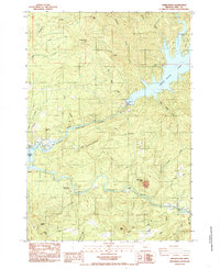
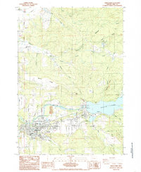
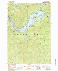 1985 Detroit1985 Print · USGSThe Oregon Cascades meet the waters of the Santiam in the 1980s, centered on the newly established reservoir culture. Local historians can trace the development of Detroit and its surrounding recreation spots like Detroit Lake State Park and Detroit Dam.
 - 1985 Map of Lyons
 1985 Lyons1985 Print · USGSThe riverfront communities of Mehama and Lyons were firmly established along the North Santiam during the mid-1980s. Genealogists and historians can trace the Southern Pacific line through the timberlands, locating landmarks like Gooch, Jordan, and Stout Creek.
 - 1985 Map of Quartzville
 1985 Quartzville1985 Print · USGSLinn County’s mining and timber country is documented here in the mid-eighties, centered on the historic Quartzville site. Researchers can trace old operations at the Albany Mine or locate early recreation spots like the Yellowbottom Campground near the Middle Santiam River.
 - 1985 Map of Mill City South
 1985 Mill City South1985 Print · USGSLinn County forest lands are captured in the mid-1980s as timber and industry shaped the landscape south of the Santiam River. Researchers can trace rural cemeteries and sites like Turnidge, or locate remote landmarks like the Landing Strip and High Rock.
 - 1985 Map of Yellowstone Mtn
 1985 Yellowstone Mtn1985 Print · USGSLinn County’s high country in the mid-1980s reveals a landscape shaped by timber management and hydroelectric watersheds. Genealogists and researchers can trace family-named landmarks like Harry Mountain and remote spots like Crabtree Lake or the Dogwood Picnic Area.
 - 1985 Map of Elkhorn
 1985 Elkhorn1985 Print · USGSMarion County's canyon country in the mid-eighties shows a river landscape shared by hydro-electric power and national forest recreation. Researchers can locate the Silver King Mine and trace early canyon access points like Niagara and Packsaddle Park.
 - 1985 Map of Jordan
 1985 Jordan1985 Print · USGSSettlements like Jordan and Bilyeu sit among the timbered ridges of Linn County in the mid-eighties. Genealogists and local historians can trace the positions of several covered bridges including Hannah Bridge and Larwood Bridge near Rogers Mountain.
 - 1985 Map of Mill City North
 1985 Mill City North1985 Print · USGSMarion and Linn counties meet along the river in the mid-1980s as timber and recreation define the local economy. Researchers can trace the development of riverside settlements like Mill City and Gates, or locate family sites near Bear Creek Park and Minto.2 unique versions available
Showing maps 1-25 of 51
Top cities of Linn County
- Lebanon historical maps
- Sweet Home historical maps
- Harrisburg historical maps
- Brownsville historical maps
- Lyons historical maps
- Tangent historical maps
See more
Frequently asked questions
- What are the different types of historical maps available for Linn County?
- What is the oldest map of Linn County?
- Where can I purchase historical maps of Linn County for my home or office?
- Where can I download high-res historical maps of Linn County?
- Are there historical topographic maps available for Linn County?
- Is there historical aerial imagery available for Linn County?
- Where are historical maps of Linn County sourced from?