1970s Maps of Linn County, Oregon
Explore 8 historic maps of Linn County from the 1970s. These maps offer a rare glimpse into what life looked like during the 1970s — showing old roads, neighborhoods, homes, and landmarks that have changed or disappeared over time.
Whether you're researching your family's past, planning a metal detecting trip, or studying how Linn County's landscape evolved across the 1970s, these high-resolution maps are a powerful tool for exploring the history of this region.
- Focus on a specific era: All maps on this page are from the 1970s, giving you a focused view of this time period.
- See what’s changed: Compare century-old streets, trails, and buildings to today's modern landscape using overlays and satellite layers.
- Research with precision: Use these maps for genealogy, historical research, land use analysis, or educational projects.
- View, download, or print: Maps are fully viewable online in high resolution, and can be downloaded or printed for your own records.
Start exploring Linn County's history through authentic maps from the 1970s. This is your window into the past.
Linn County, OR maps
(8)- 1970 Map of Albany, 1972 Print
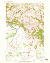
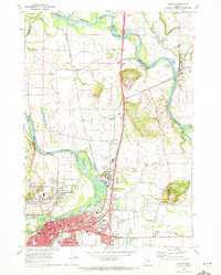 1970 Albany1972 Print · USGSThe Albany and Jefferson corridor in the early seventies shows a landscape defined by the WILLAMETTE RIVER and major rail lines. Genealogists can trace family roots through numerous sites like Waverly Cemetery, Dever School, and Hale Butte.3 unique versions available
 - 1970 Map of Monmouth, 1972 Print
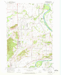
 1970 Monmouth1972 Print · USGSThe Willamette Valley comes alive in the early seventies, showing the established campus of Oregon College of Education and the riverfront at Independence. Genealogists and historians can trace the Southern Pacific tracks, local schools like Talmadge Jr High Sch, and riverside points including Wigrich Landing.2 unique versions available
 - 1970 Map of Lewisburg, 1972 Print
 1970 Lewisburg1972 Print · USGSBenton County's mid-century landscape is preserved here as it transitioned from a military center to a game management area. Genealogists can locate Gingles Cem and Locke Cem, or trace the tracks of the Southern Pacific and Oregon Electric railroads.3 unique versions available
 - 1970 Map of Crabtree, 1972 Print
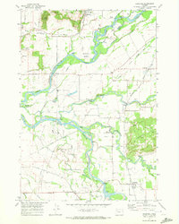 1970 Crabtree1972 Print · USGSThe Santiam River valley in the early seventies shows a landscape defined by its waterways and rail connections. Local researchers can trace old road networks like Old Sucker Road and find landmarks such as the Riverview Community Hall and several Covered Bridge crossings.2 unique versions available
 - 1970 Map of Sidney, 1972 Print
 1970 Sidney1972 Print · USGSMarion County south of Salem is shown here in the early seventies as a rich agricultural and riparian landscape. Genealogists can locate family names and burial sites at Rosedale Cem and Looney Cem or trace the old Oregon Electric rail line through Talbot and Sidney.3 unique versions available
 - 1975 Map of Corvallis, 1980 Print
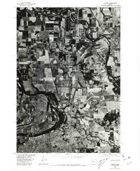
 1975 Corvallis1980 Print · USGSThe Willamette Valley communities of Corvallis and Philomath are shown in detail during the mid-seventies through this aerial survey. Local historians and genealogists can trace the expansion of neighborhood grids and follow the path of the Booneville Channel.
 - 1976 Map of Albany, 1980 Print
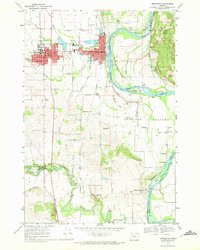
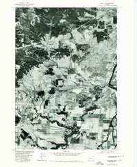
 1976 Albany1980 Print · USGSThe Willamette Valley at the Bicentennial is captured in this orthophotograph, showcasing the agricultural heart of Oregon. Researchers can trace the mid-century footprints of Albany, North Albany, and Jefferson along the winding Santiam River.
 - 1976 Map of Lebanon, 1981 Print
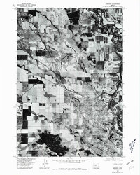 1976 Lebanon1981 Print · USGSThe Willamette Valley community of Lebanon is captured mid-century in this detailed aerial survey. Researchers can trace the layout of the town and nearby Crowfoot, or examine the rural landscape around Peterson Butte and the Burkhart Creek drainage.
End of results
Showing maps 1-8 of 8
Top cities of Linn County
- Lebanon historical maps
- Sweet Home historical maps
- Harrisburg historical maps
- Brownsville historical maps
- Lyons historical maps
- Tangent historical maps
See more
Frequently asked questions
- What are the different types of historical maps available for Linn County?
- What is the oldest map of Linn County?
- Where can I purchase historical maps of Linn County for my home or office?
- Where can I download high-res historical maps of Linn County?
- Are there historical topographic maps available for Linn County?
- Is there historical aerial imagery available for Linn County?
- Where are historical maps of Linn County sourced from?