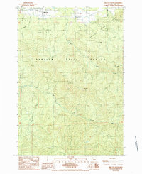
1985 Map of Mill City South
USGS Topo · Published 1985About this map
Santiam State Forest dominates this mid-1980s landscape south of Mill City, where the terrain transitions from the developed edge of the North Santiam River valley into the Cascades foothills. The map reveals the early industrial and recreational footprint of the region, specifically near the settlement of Turnidge. Notable landmarks include a high-elevation Landing Strip and a Cem (cemetery), indicating established communities and logistical operations tucked into the timberland.
Find a feature on this map
23 named features on this map. Tap any name to fly to it.
Don’t see what you’re looking for? This feature index may not catch every label — zoom into the map to look around manually.
Map Details
Editions of this 1985 Mill City South Map
This is the sole edition of this map. No revisions or reprints were ever made.
Other maps of this area

1929 · Mill City
USGS Topo · 1:125,000

1951 · Lyons
USGS Topo · 1:62,500

1951 · Snow Peak
USGS Topo · 1:62,500

1953 · Salem
USGS Topo · 1:250,000

1954 · Salem
USGS Topo · 1:250,000

1955 · Mill City
USGS Topo · 1:62,500

1956 · Quartzville
USGS Topo · 1:62,500

1960 · Salem
USGS Topo · 1:250,000

1962 · Salem
USGS Topo · 1:250,000

1963 · Salem
USGS Topo · 1:250,000