1950s Maps of Malheur County, Oregon
Explore 31 historic maps of Malheur County from the 1950s. These maps offer a rare glimpse into what life looked like during the 1950s — showing old roads, neighborhoods, homes, and landmarks that have changed or disappeared over time.
Whether you're researching your family's past, planning a metal detecting trip, or studying how Malheur County's landscape evolved across the 1950s, these high-resolution maps are a powerful tool for exploring the history of this region.
- Focus on a specific era: All maps on this page are from the 1950s, giving you a focused view of this time period.
- See what’s changed: Compare century-old streets, trails, and buildings to today's modern landscape using overlays and satellite layers.
- Research with precision: Use these maps for genealogy, historical research, land use analysis, or educational projects.
- View, download, or print: Maps are fully viewable online in high resolution, and can be downloaded or printed for your own records.
Start exploring Malheur County's history through authentic maps from the 1950s. This is your window into the past.
Malheur County, OR maps
(31)- 1950 Map of Jamieson, 1952 Print
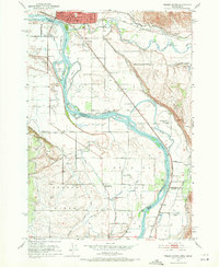
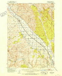 1950 Jamieson1952 Print · USGSEastern Oregon ranching and railroad life come into focus in the early fifties, following the path of the Union Pacific through Malheur County. Genealogists and historians can trace the irrigation networks of the Vale Main Canal and locate the Bully Creek School and Lancaster.3 unique versions available
 - 1951 Map of Moores Hollow, 1952 Print
 1951 Moores Hollow1952 Print · USGSThe high desert of Malheur County meets the winding Snake River in the early fifties, marking the border between Oregon and Idaho. Researchers can trace early irrigation networks like the Owyhee Canal and find family-named landmarks such as Jacobsen Gulch and McRea Island.4 unique versions available
 - 1951 Map of Malheur Butte, 1952 Print
 1951 Malheur Butte1952 Print · USGSEastern Oregon agriculture and infrastructure are captured here in the early fifties as irrigation transformed the high desert. Researchers can trace the development of rural social life and utility networks near Malheur Butte and the Ontario Heights Grange.4 unique versions available
 - 1951 Map of Moores Hollow, 1953 Print
 1951 Moores Hollow1953 Print · USGSThe Oregon-Idaho borderlands thrive on river-fed irrigation and rail transport in the early fifties. Genealogists can trace family footprints near Annex and Ontario Heights or locate the historic path of the Oregon Trail as it nears the Snake River.3 unique versions available
 - 1951 Map of Payette, 1953 Print
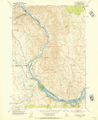
 1951 Payette1953 Print · USGSThe Snake River valley in the early fifties is captured here at the busy intersection of the Pacific Northwest's rail and river networks. Researchers can trace the Old Oregon Trail Highway or locate local landmarks like the Orchard Ave Grange Hall and Riverside Cemetery.3 unique versions available
 - 1951 Map of Huntington, 1953 Print
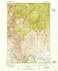
 1951 Huntington1953 Print · USGSEastern Oregon in the early fifties shows a landscape shaped by the Union Pacific and the historic Oregon Trail. Researchers can trace the river-and-rail economy through the Placer Mines of Dixie Creek and the industrial works at Lime.3 unique versions available
 - 1951 Map of Weiser South, 1971 Print
 1951 Weiser South1971 Print · USGSThe borderlands of Idaho and Oregon come alive in this mid-century survey of the Snake River valley. Local historians can trace the transition of rural education and irrigation through Eastside Sch, Annex Cem, and the extensive Hyline Ditch network.2 unique versions available
 - 1952 Map of Olds Ferry, 1954 Print
 1952 Olds Ferry1954 Print · USGSThe Snake River crossing at the Idaho-Oregon border was a vital transit point for pioneers and early rail travelers during the mid-twentieth century. Trace the path of the Old Oregon Trail Highway past the Original Site Olds Ferry and the Coal Mine near Indian Head Mtn.3 unique versions available
 - 1952 Map of Olds Ferry, 1956 Print
 1952 Olds Ferry1956 Print · USGSThe Snake River canyon and the historic Oregon-Idaho borderlands are captured here in the early fifties, showing the region's transition from pioneer routes to modern infrastructure. Researchers can trace the Oregon Trail, locate early crossing points like Olds Ferry (Site), and find defunct rural schoolhouses such as Eaton Sch (Aband).3 unique versions available
 - 1952 Map of Olds Ferry SE, 1976 Print
 1952 Olds Ferry SE1976 Print · USGSThe Snake River borderlands in the early fifties show a landscape of irrigation canals and early schoolhouses. Genealogists can trace the location of Porters Ferry (Site) and several rural campuses like Central School and Hale School.
 - 1954 Map of Vya, 1967 Print
 1954 Vya1967 Print · USGSThe tri-state corner of Nevada, Oregon, and California appears here in the mid-fifties, dominated by wildlife refuges and massive naval gunnery ranges. Trace isolated high-desert outposts like Vya and Soldier Meadow Ranch or find historic workings at the Ashdown Mine.3 unique versions available
 - 1955 Map of McDermitt
 1955 McDermitt1955 Print · USGSNorthern Nevada in the mid-fifties shows a landscape of mining camps and vast cattle ranges. Trace the early footprints of Tuscarora or the remote Cordero Mine and National Mine tucked into the high desert peaks.3 unique versions available
 - 1955 Map of Jordan Valley, 1963 Print
 1955 Jordan Valley1963 Print · USGSThe high desert of Malheur County comes alive in the mid-1950s, showing the isolated ranching outposts and deep canyons along the Idaho border. Researchers can trace the remote reaches of the Owyhee River, the cattle town of Jordan Valley, and mining landmarks like War Eagle Mountain.3 unique versions available
 - 1955 Map of Baker, 1964 Print
 1955 Baker1964 Print · USGSThe Oregon-Idaho borderlands are captured here in the mid-fifties as the Snake River underwent massive changes from dam construction. Trace the Oregon Trail Memorial Monument near Baker, find early mines like Virtue Mine, and follow the Union Pacific Railroad through Huntington.4 unique versions available
 - 1955 Map of Burns, 1964 Print
 1955 Burns1964 Print · USGSHarney County's high desert ranching and timber heartland is captured here in the mid-fifties, centered on the hub of Burns and Hines. Genealogists and researchers can locate remote landmarks like the Suntex School, New Princeton P. O., and the Lumber Mill.3 unique versions available
 - 1955 Map of Canyon City, 1966 Print
 1955 Canyon City1966 Print · USGSCentral Oregon's high desert and timber country are captured here in the mid-fifties, showing the rugged ranching and logging landscape. Trace the path of the Sumpter Valley Ry or locate remote settlements like Izee, Whitney, and Ritter.4 unique versions available
 - 1955 Map of Adel, 1971 Print
 1955 Adel1971 Print · USGSSoutheast Oregon in the mid-fifties remains a landscape of vast alkaline basins and high mountain scarps, anchored by remote outposts. Researchers can trace historic ranching routes through Catlow Valley and locate landmarks like Beatys Butte or the small settlement of Blitzen.2 unique versions available
 - 1955 Map of Boise, 1977 Print
 1955 Boise1977 Print · USGSThe Treasure Valley and Owyhee uplands are shown in detail during the mid-fifties, capturing the region's transition into a major agricultural and urban hub. Researchers can trace the Union Pacific line through Nampa, explore the volcanic Jordan Craters, or locate the historic mining district of Silver City.
 - 1957 Map of Adel
 1957 Adel1957 Print · USGSSoutheast Oregon in the mid-fifties reveals a high-desert landscape of sprawling ranches and vast wildlife refuges before modern development. Genealogists and researchers can trace the remote outposts of the region, from the Red Point School to historic headquarters like the Guano Ranch and Frenchglen.
 - 1957 Map of Jordan Valley
 1957 Jordan Valley1957 Print · USGSThe high-desert borderlands of Oregon and Idaho appear in the mid-fifties as a world of remote cattle ranches and mining claims. Researchers can trace historic family-named locations like Bowden Ranch and Riddle alongside the South Mountain Mining Company.
 - 1958 Map of Burns
 1958 Burns1958 Print · USGSHarney County ranching and timber lands are captured here in the late fifties. Genealogists and local historians can trace family holdings and rural institutions, from the Kimball Flat School to remote outposts like Crow Camp Ranch and the Sutton Ranch.
 - 1958 Map of Vya
 1958 Vya1958 Print · USGSNorthwest Nevada and the tri-state border region are mapped here during the mid-fifties, showing a remote landscape of high desert ranches and sprawling antelope range. Trace historic operations like the Ashdown Mine, find local camps like Coyote Camp, and locate isolated outposts from Vya to Denio.2 unique versions available
 - 1958 Map of Boise
 1958 Boise1958 Print · USGSThe Treasure Valley and Snake River Plain come alive in the mid-fifties as the rail-and-river economy transitions into a modern agricultural hub. Trace the Union Pacific lines through Nampa or locate remote landmarks like Initial Point and the Rockville settlement.2 unique versions available
 - 1958 Map of Adel
 1958 Adel1958 Print · USGSSoutheastern Oregon in the mid-fifties is captured here, showing a vast territory of high desert basins and isolated ranching outposts. Genealogists and researchers can trace the locations of the Red Point School, Frenchglen, and remote sites like Guano Ranch.2 unique versions available
 - 1958 Map of Jordan Valley
 1958 Jordan Valley1958 Print · USGSSoutheast Oregon and Southwest Idaho are documented here during the mid-fifties, showing a landscape of remote cattle ranches and volcanic badlands. Genealogists and historians can trace family operations like the Bowden Ranch or locate the Pleasant Valley School and the South Mountain Mining Company.2 unique versions available
Showing maps 1-25 of 31
Top cities of Malheur County
- Ontario historical maps
- Nyssa historical maps
- Vale historical maps
- Adrian historical maps
- Jordan Valley historical maps
Frequently asked questions
- What are the different types of historical maps available for Malheur County?
- What is the oldest map of Malheur County?
- Where can I purchase historical maps of Malheur County for my home or office?
- Where can I download high-res historical maps of Malheur County?
- Are there historical topographic maps available for Malheur County?
- Is there historical aerial imagery available for Malheur County?
- Where are historical maps of Malheur County sourced from?