1970s Maps of Union County, Oregon
Explore 5 historic maps of Union County from the 1970s. These maps offer a rare glimpse into what life looked like during the 1970s — showing old roads, neighborhoods, homes, and landmarks that have changed or disappeared over time.
Whether you're researching your family's past, planning a metal detecting trip, or studying how Union County's landscape evolved across the 1970s, these high-resolution maps are a powerful tool for exploring the history of this region.
- Focus on a specific era: All maps on this page are from the 1970s, giving you a focused view of this time period.
- See what’s changed: Compare century-old streets, trails, and buildings to today's modern landscape using overlays and satellite layers.
- Research with precision: Use these maps for genealogy, historical research, land use analysis, or educational projects.
- View, download, or print: Maps are fully viewable online in high resolution, and can be downloaded or printed for your own records.
Start exploring Union County's history through authentic maps from the 1970s. This is your window into the past.
Union County, OR maps
(5)- 1972 Map of Trout Meadows, 1975 Print
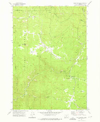 1972 Trout Meadows1975 Print · USGSThe Grant County wilderness in the early 1970s reveals a landscape shaped by river mining and high-altitude timber. Researchers can trace historic extraction sites like Klopp Placer Mine and remote backcountry hubs like Happy Prairie or Trout Meadows.3 unique versions available
 - 1972 Map of Rock Creek, 1976 Print
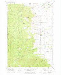 1972 Rock Creek1976 Print · USGSNorth Powder Valley is shown in the early 1970s, revealing a complex landscape of irrigation ditches and timber heritage. Researchers can locate the Yankee Sawmill (Site), the Muddy Creek Sch, and geothermal Fisher Hot Springs.2 unique versions available
 - 1972 Map of Anthony Lakes, 1976 Print
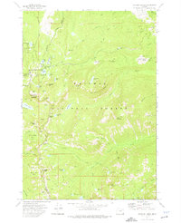 1972 Anthony Lakes1976 Print · USGSHigh in the Blue Mountains during the early 1970s, this area shows a landscape of alpine lakes and mining history at the meeting point of three counties. Researchers can locate the Loy Mine, trace the North Fork Powder River, and explore remote basins like Cunningham Cove.2 unique versions available
 - 1972 Map of Crawfish Lake, 1976 Print
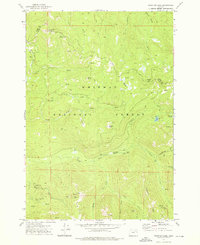 1972 Crawfish Lake1976 Print · USGSThe Grant County high country comes into focus in the 1970s, showing a landscape shaped by high-altitude mining and the headwaters of major rivers. Researchers can trace the history of mountain extraction at the Continental Mine, visit the site of Cabell City, or follow the North Fork John Day River through the Whitman National Forest.2 unique versions available
 - 1979 Map of La Grande, 1980 Print
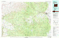 1979 La Grande1980 Print · USGSNorthwestern Oregon’s mountain corridors are captured here in the late seventies, showing the rail and river networks through the Blue Mountains. Trace the Old Emigrant Road, locate the Aurelia Mine, or explore the Starkey Experimental Forest.2 unique versions available
End of results
Showing maps 1-5 of 5
Top cities of Union County
- La Grande historical maps
- Union historical maps
- Elgin historical maps
- Island City historical maps
- Cove historical maps
- North Powder historical maps
See more
Frequently asked questions
- What are the different types of historical maps available for Union County?
- What is the oldest map of Union County?
- Where can I purchase historical maps of Union County for my home or office?
- Where can I download high-res historical maps of Union County?
- Are there historical topographic maps available for Union County?
- Is there historical aerial imagery available for Union County?
- Where are historical maps of Union County sourced from?