1960s Maps of Wheeler County, Oregon
Explore 15 historic maps of Wheeler County from the 1960s. These maps offer a rare glimpse into what life looked like during the 1960s — showing old roads, neighborhoods, homes, and landmarks that have changed or disappeared over time.
Whether you're researching your family's past, planning a metal detecting trip, or studying how Wheeler County's landscape evolved across the 1960s, these high-resolution maps are a powerful tool for exploring the history of this region.
- Focus on a specific era: All maps on this page are from the 1960s, giving you a focused view of this time period.
- See what’s changed: Compare century-old streets, trails, and buildings to today's modern landscape using overlays and satellite layers.
- Research with precision: Use these maps for genealogy, historical research, land use analysis, or educational projects.
- View, download, or print: Maps are fully viewable online in high resolution, and can be downloaded or printed for your own records.
Start exploring Wheeler County's history through authentic maps from the 1960s. This is your window into the past.
Wheeler County, OR maps
(15)- 1966 Map of Peterson Point, 1968 Print
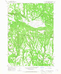
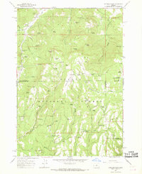 1966 Peterson Point1968 Print · USGSThe high backcountry of the Ochoco Mountains is mapped in the mid-1960s, showing a rugged landscape of volcanic flows and forest trails. Researchers can trace historic access routes like the Keeton Trail or locate isolated sites such as Lonesome Spring Campground and Packsaddle Reservoir.2 unique versions available
 - 1966 Map of Mt. Pisgah, 1968 Print
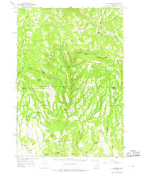
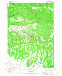 1966 Mt. Pisgah1968 Print · USGSThe high Ochoco mountain country is captured here during the mid-sixties, showing a landscape of forest service lookouts and remote cattle camps. Researchers can locate specific range sites like Wineburger Camp, the Badger Cabin, and the lookout atop Mt Pisgah.2 unique versions available
 - 1966 Map of Antone, 1968 Print
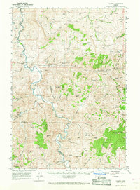
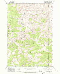
 1966 Antone1968 Print · USGSWheeler County ranching and mining operations are captured here during the mid-sixties, from the high peaks of the forest to the deep gulches below. Researchers can trace local heritage at Antone, locate the Waterman Mine, or find the small Cem and isolated Grave.2 unique versions available
 - 1966 Map of Derr Meadows, 1968 Print
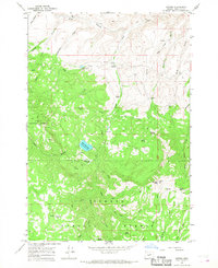
 1966 Derr Meadows1968 Print · USGSWheeler and Crook counties meet in the high Ochoco National Forest during the mid-1960s, a period of active forest management and remote ranching. Researchers can locate the Camp Watson site, its nearby Cemetery, and the Derr Guard Station.2 unique versions available
 - 1966 Map of Little Summit Prairie, 1968 Print
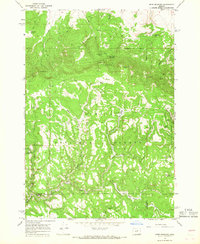
 1966 Little Summit Prairie1968 Print · USGSHigh-altitude meadows and timberlands in Crook County are captured here in the mid-1960s. Researchers can trace the historical Military Road and locate remote water sources like Hewed Log Spring and Ruby Reservoir.2 unique versions available
 - 1966 Map of Six Corners, 1968 Print
 1966 Six Corners1968 Print · USGSThe high timberlands of the Wheeler and Crook county border are captured here in the mid-1960s as forestry infrastructure was expanding. Map collectors and historians can trace the development of backcountry roads and find remote water features like Yu-ma Spring, Scab Reservoir, and the Potter Meadows high country.2 unique versions available
 - 1966 Map of Mitchell, 1968 Print
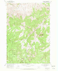
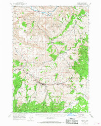 1966 Mitchell1968 Print · USGSMitchell and the high desert of Central Oregon are captured here in the late sixties, showcasing a landscape of high buttes and isolated ranchlands. Genealogists can trace family footprints at Richmond Cemetery, the Gable Creek School, and the Old Frizzell Ranch.2 unique versions available
 - 1966 Map of Kinzua, 1968 Print
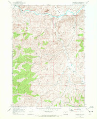
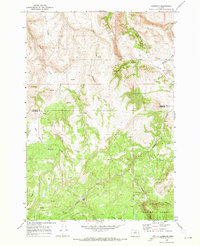
 1966 Kinzua1968 Print · USGSWheeler County timber and river life are captured here in the mid-1960s, showing the intersection of logging and ranching. Trace the path of the Kinzua Pine Mills Co RR or locate family sites like Sutton Ranch and the IOOF Cem.
 - 1966 Map of Clarno, 1969 Print
 1966 Clarno1969 Print · USGSThe John Day River corridor in the mid-1960s reveals a landscape of remote ranching outposts and geological landmarks. Researchers can trace family history through sites like Tillotson Cem, the Lower Pine Creek Sch, and the Knox Ranch.
 - 1968 Map of Painted Hills, 1972 Print
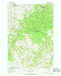
 1968 Painted Hills1972 Print · USGSWheeler County ranching and geology are frozen in time during the late sixties, where the winding John Day River meets the high desert. Researchers can trace the layout of the Painted Hills State Park or locate the historic Burnt Ranch and Taylor Ranch.
 - 1968 Map of Lawson Mtn, 1972 Print
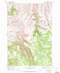
 1968 Lawson Mtn1972 Print · USGSWheeler County high country comes into focus in the late sixties, showcasing the high summits and cattle ranching flats of the northern Ochoco range. Genealogists and historians can locate Fitzgerald Ranch, the West Branch Cemetery, and the iconic Courthouse Rock.2 unique versions available
 - 1968 Map of Stephenson Mtn, 1972 Print
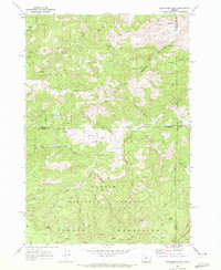 1968 Stephenson Mtn1972 Print · USGSThe high Ochoco Mountains and national forest lands are captured here in the late sixties, where three counties converge at the edge of the wilderness. Trace old mining operations and high-country landmarks like the Lucky Strike Mine, Ludwick Cabin, and Old Stephenson Ranch.2 unique versions available
 - 1968 Map of Sandrock Mtn, 1972 Print
 1968 Sandrock Mtn1972 Print · USGSJefferson and Wheeler counties remained a frontier of ranching and prospecting in the late 1960s. Genealogists and historians can trace high-desert land use through landmarks like Upper Cherry Creek Ranch, Fitzgerald Ranch, and numerous named water sources like Broken Shovel Spring.
 - 1969 Map of Lefevre Prairie, 1972 Print
 1969 Lefevre Prairie1972 Print · USGSHigh-country prairies and deep canyons meet at the intersection of three counties during the late sixties. Genealogists and hikers can trace the Lonerock Cem, explore the reaches of The Frog, or follow the timbered boundaries of the Umatilla National Forest.2 unique versions available
 - 1969 Map of Lonerock, 1973 Print
 1969 Lonerock1973 Print · USGSLonerock and the high plateau country of the Gilliam and Wheeler county line appear here as they were in the late sixties. Genealogists and researchers can locate the Lonerock settlement and local Cem, or trace landmarks like Cone Mill and the Jeep Tr.2 unique versions available
End of results
Showing maps 1-15 of 15
Top cities of Wheeler County
Frequently asked questions
- What are the different types of historical maps available for Wheeler County?
- What is the oldest map of Wheeler County?
- Where can I purchase historical maps of Wheeler County for my home or office?
- Where can I download high-res historical maps of Wheeler County?
- Are there historical topographic maps available for Wheeler County?
- Is there historical aerial imagery available for Wheeler County?
- Where are historical maps of Wheeler County sourced from?