1920s Maps of Somerset County, Pennsylvania
Explore 8 historic maps of Somerset County from the 1920s. These maps offer a rare glimpse into what life looked like during the 1920s — showing old roads, neighborhoods, homes, and landmarks that have changed or disappeared over time.
Whether you're researching your family's past, planning a metal detecting trip, or studying how Somerset County's landscape evolved across the 1920s, these high-resolution maps are a powerful tool for exploring the history of this region.
- Focus on a specific era: All maps on this page are from the 1920s, giving you a focused view of this time period.
- See what’s changed: Compare century-old streets, trails, and buildings to today's modern landscape using overlays and satellite layers.
- Research with precision: Use these maps for genealogy, historical research, land use analysis, or educational projects.
- View, download, or print: Maps are fully viewable online in high resolution, and can be downloaded or printed for your own records.
Start exploring Somerset County's history through authentic maps from the 1920s. This is your window into the past.
Somerset County, PA maps
(8)- 1920 Map of New Florence, 1958 Print
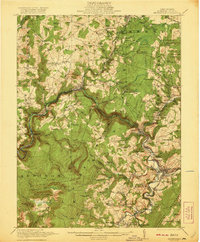
 1920 New Florence1958 Print · USGSThe Conemaugh River valley at the dawn of the 1920s shows a landscape defined by the PENNSYLVANIA RR and industrial coal towns. Genealogists can locate family homesteads near dozens of named country schools like Wallace School or trace the old Lincoln Highway through Armagh.
 - 1921 Map of New Florence
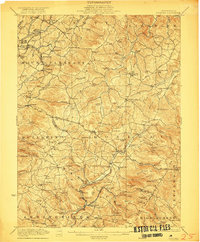
 1921 New Florence1921 Print · USGSWestmoreland and Indiana counties are captured in the early 1920s as industrial rail corridors and the Lincoln Highway begin to modernize the rural landscape. Genealogists can locate family landmarks like Campbell's Mill, the Centerville Huff PO, and several country schools including Robbs School.
 - 1921 Map of Meyersdale
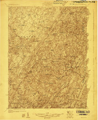
 1921 Meyersdale1921 Print · USGSSomerset County's industrial and mountain landscape comes to life in the early 1920s as coal mining and railroads dominate the Casselman River valley. Genealogists can trace family roots through dozens of local sites like Sanners Church, Shaw Mines, and the Ganguey School.3 unique versions available
 - 1922 Map of Confluence
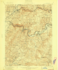
 1922 Confluence1922 Print · USGSThe confluence of the Youghiogheny River and Casselman River was a major rail and river hub in the 1920s. Genealogists and local historians can trace the foundations of many small settlements and mountain schools, from Ohiopyle to the Baldwin Mine and Wesley Chapel.3 unique versions available
 - 1922 Map of Donegal
 1922 Donegal1922 Print · USGSWestmoreland and Fayette counties are captured here in the early twenties, showing a landscape of mountain ridges and busy valley crossroads. Genealogists can trace family roots through dozens of rural landmarks like St Boniface Chapel, Hoods Mill, and the Snowball School.2 unique versions available
 - 1922 Map of New Florence
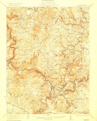
 1922 New Florence1922 Print · USGSWestern Pennsylvania in the early 1920s shows a landscape of river-carved ridges and busy rail corridors connecting coal and quarry towns. Genealogists can trace family footprints across dozens of rural schools and stations like Lockport Station, Centerville (Huff PO), and Grafton.5 unique versions available
 - 1923 Map of Berlin
 1923 Berlin1923 Print · USGSSomerset County’s high ridges and deep valleys are documented in the early 1920s as the rail and mining industries shaped the local economy. Genealogists and researchers can locate numerous family-named landmarks and rural hubs, including Butners Mill, Sand Patch, and the Shipley Brothers Mine.3 unique versions available
 - 1929 Map of Berlin
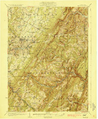 1929 Berlin1929 Print · USGSSomerset County is shown here in the late twenties, during the peak of the mountain coal and rail era. Genealogists and historians can trace family roots through dozens of rural landmarks like Whiteoak Churches, Salco Mines, and the Falls Cut Tunnel along the B&O line.3 unique versions available
End of results
Showing maps 1-8 of 8
Top cities of Somerset County
- Somerset historical maps
- Windber historical maps
- Meyersdale historical maps
- Berlin historical maps
- Boswell historical maps
- Central City historical maps
See more
Frequently asked questions
- What are the different types of historical maps available for Somerset County?
- What is the oldest map of Somerset County?
- Where can I purchase historical maps of Somerset County for my home or office?
- Where can I download high-res historical maps of Somerset County?
- Are there historical topographic maps available for Somerset County?
- Is there historical aerial imagery available for Somerset County?
- Where are historical maps of Somerset County sourced from?