1940s Maps of Somerset County, Pennsylvania
Explore 18 historic maps of Somerset County from the 1940s. These maps offer a rare glimpse into what life looked like during the 1940s — showing old roads, neighborhoods, homes, and landmarks that have changed or disappeared over time.
Whether you're researching your family's past, planning a metal detecting trip, or studying how Somerset County's landscape evolved across the 1940s, these high-resolution maps are a powerful tool for exploring the history of this region.
- Focus on a specific era: All maps on this page are from the 1940s, giving you a focused view of this time period.
- See what’s changed: Compare century-old streets, trails, and buildings to today's modern landscape using overlays and satellite layers.
- Research with precision: Use these maps for genealogy, historical research, land use analysis, or educational projects.
- View, download, or print: Maps are fully viewable online in high resolution, and can be downloaded or printed for your own records.
Start exploring Somerset County's history through authentic maps from the 1940s. This is your window into the past.
Somerset County, PA maps
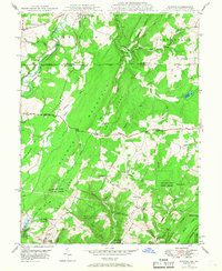
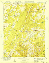
(18)- 1944 Map of Somerset
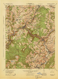
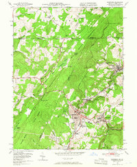
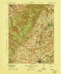 1944 Somerset1944 Print · USGSThe Laurel Highlands during the early years of the Pennsylvania Turnpike are captured here, showing the transition from old mountain roads to modern highways. Genealogists can trace family names at Rector Mill, Rhoads Field, and dozens of local schools like Knepper Sch.
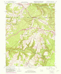
 - 1944 Map of Windber
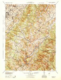
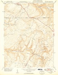
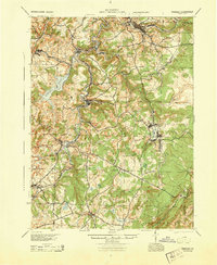 1944 Windber1944 Print · USGSSomerset County's coal and rail corridors are captured here during the 1940s, showing the region's industrial peak. Genealogists can locate family landmarks like Kaufman Ch, Stoystown Sta, and numerous country schools such as Breastwork Sch.
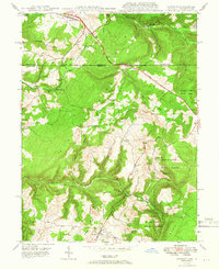
 - 1944 Map of New Florence
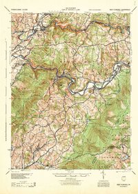 1944 New Florence1944 Print · USGSWestmoreland and Indiana counties during the wartime years reveal a landscape shaped by coal, steam, and rail. Genealogists can trace family footprints in vanished settlements and school districts like Robindale Smokeless PO, Scottglen Sta, and Mahan Sch.
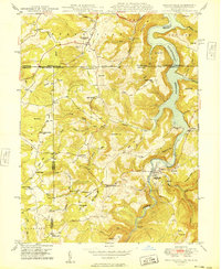
 - 1944 Map of Berlin
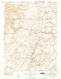
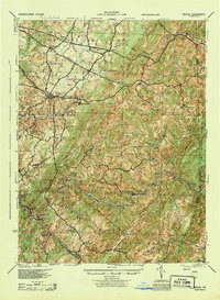 1944 Berlin1944 Print · USGSSomerset County was undergoing a major transformation in the 1940s as the Pennsylvania Turnpike and its Allegheny Tunnel modernised the landscape. Researchers can trace rural family roots at sites like Sandy Hollow Sch, Lebanon Ch, and old operations like the Salco Mines.
 - 1944 Map of Meyersdale, 1945 Print
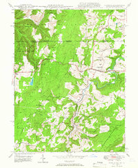
 1944 Meyersdale1945 Print · USGSSomerset County’s rugged coal and timber country is frozen in time during the mid-1940s, showing a landscape defined by the Casselman River and its busy rail lines. Genealogists can locate dozens of named rural landmarks like Plank Road Sch, Mt Zion Ch, and the Beachley Mine.
 - 1944 Map of Donegal, 1945 Print
 1944 Donegal1945 Print · USGSWestmoreland and Fayette Counties are shown in the 1940s just as the Pennsylvania Turnpike was changing the landscape. Genealogists and historians can trace dozens of rural schools and churches, from Stauffer Sch to St Boniface Chapel.
 - 1946 Map of Grantsville, 1966 Print
 1946 Grantsville1966 Print · USGSGarrett County's high ridges and river valleys are captured here in the mid-1940s, showing a landscape defined by the historic National Pike and timbered heights. Genealogists can locate family-named features such as Zehner Hill, Yoder School, and the remote Dunghill Church.4 unique versions available
 - 1947 Map of Friendsville, 1965 Print
 1947 Friendsville1965 Print · USGSMaryland's mountainous panhandle meets Pennsylvania and West Virginia in this mid-century study of the Youghiogheny valley. Genealogists can locate family landmarks like Thomas Cemetery and Emberson Cemetery, or rural schoolhouses like McCabe School.6 unique versions available
 - 1947 Map of Avilton, 1968 Print
 1947 Avilton1968 Print · USGSMaryland's high mountain ridges and the historic Mason-Dixon boundary are captured here in the late 1940s. Genealogists and historians can locate old mountain homesteads, the Avilton Sch, and rural cemeteries like Merrbach Cem or the Blocher Cem.4 unique versions available
 - 1947 Map of Accident, 1982 Print
 1947 Accident1982 Print · USGSMaryland's high plateau comes into focus at the middle of the century, centered on the historic National Road and the uniquely named town of Accident. Genealogists and local historians can trace family-named landmarks like Kaese Mill, Sausman Mine, and several rural Cem locations throughout the Bear Creek valley.2 unique versions available
 - 1948 Map of Cumberland
 1948 Cumberland1948 Print · USGSMid-century Appalachia and the Shenandoah Valley are shown in detail, documenting the industrial and transportation hubs of the tri-state area. Genealogists can trace family roots through settlements like Double Tollgate and Bunker Hill or along the Baltimore & Ohio RR.3 unique versions available
 - 1948 Map of Accident, 1966 Print
 1948 Accident1966 Print · USGSGarrett County's high ridges and small mountain communities are captured here in the late 1940s as the regional timber and milling economy thrived. Researchers can trace historic family locations like Turney Cem, local industry at the Swanton Mine, and early transport along the National Pike.2 unique versions available
 - 1949 Map of Friendsville
 1949 Friendsville1949 Print · USGSThe tri-state borderlands of Maryland, Pennsylvania, and West Virginia appear here in the late 1940s, centered on the growing Youghiogheny Reservoir. Genealogists and historians can trace family landmarks along the Mason And Dixon Line, from Thomas Cem to the early roads of Friendsville.
 - 1949 Map of Avilton
 1949 Avilton1949 Print · USGSThe Maryland-Pennsylvania borderlands in the late 1940s are defined by high ridges and mountain crossroads like Avilton and Piney Grove. Genealogists can locate family landmarks such as Mt Zion Ch Cem, Blocher Cem, and the old Avilton Sch.
 - 1949 Map of Grantsville
 1949 Grantsville1949 Print · USGSGarrett County highlands and the Pennsylvania border are captured here just after the war as the mountain economy transitioned from timber and mining to modern transit. Genealogists can trace family names through Maple Grove Cem, Bevansville, and rural landmarks like The Dunghill.2 unique versions available
 - 1949 Map of Accident
 1949 Accident1949 Print · USGSThe Maryland-Pennsylvania borderlands near Accident are captured here in the late 1940s, showing a rural landscape of ridges and milling sites. Genealogists and historians can trace local family landmarks like Turney Cem, the Rich Sch, and old industry at Kaese Mill.2 unique versions available
 - 1949 Map of Cumberland, 1955 Print
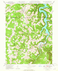
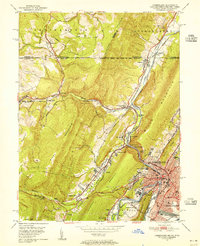 1949 Cumberland1955 Print · USGSCumberland and the Potomac River valley are shown in detail at mid-century, just as the region's rail and coal infrastructure reached its post-war peak. Local historians can trace the Mason and Dixon Line and locate historic landmarks like Sixmile House and The Narrows.10 unique versions available
 - 1949 Map of Frostburg, 1966 Print
 1949 Frostburg1966 Print · USGSFrostburg and the surrounding coalfields are captured here in the late 1940s, showing a region defined by heavy rail and extractive industry. Genealogists can trace family roots through industrial settlements like Eckhart Mines, Grahamtown, and the Borden Shaft.3 unique versions available
End of results
Showing maps 1-18 of 18
Top cities of Somerset County
- Somerset historical maps
- Windber historical maps
- Meyersdale historical maps
- Berlin historical maps
- Boswell historical maps
- Central City historical maps
See more
Frequently asked questions
- What are the different types of historical maps available for Somerset County?
- What is the oldest map of Somerset County?
- Where can I purchase historical maps of Somerset County for my home or office?
- Where can I download high-res historical maps of Somerset County?
- Are there historical topographic maps available for Somerset County?
- Is there historical aerial imagery available for Somerset County?
- Where are historical maps of Somerset County sourced from?