1940s Maps of Washington County, Pennsylvania
Explore 6 historic maps of Washington County from the 1940s. These maps offer a rare glimpse into what life looked like during the 1940s — showing old roads, neighborhoods, homes, and landmarks that have changed or disappeared over time.
Whether you're researching your family's past, planning a metal detecting trip, or studying how Washington County's landscape evolved across the 1940s, these high-resolution maps are a powerful tool for exploring the history of this region.
- Focus on a specific era: All maps on this page are from the 1940s, giving you a focused view of this time period.
- See what’s changed: Compare century-old streets, trails, and buildings to today's modern landscape using overlays and satellite layers.
- Research with precision: Use these maps for genealogy, historical research, land use analysis, or educational projects.
- View, download, or print: Maps are fully viewable online in high resolution, and can be downloaded or printed for your own records.
Start exploring Washington County's history through authentic maps from the 1940s. This is your window into the past.
Washington County, PA maps
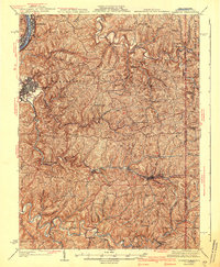
(6)- 1940 Map of Brownsville
 1940 Brownsville1940 Print · USGSThe Monongahela and Youghiogheny river valleys were the industrial heart of Pennsylvania during this era of coal and steel. Genealogists and historians can trace the exact locations of Vesta Mine, Salem Church, and historic rural schools like Central Sch.
 - 1942 Map of Cameron
 1942 Cameron1942 Print · USGSThe northern panhandle in the early 1940s reveals a landscape of riverfront industry and remote ridge-top schools. Genealogists can locate family landmarks like Beelers Station, Blairs Ridge Ch, and the curiously named Squirrel Alley Sch.2 unique versions available
 - 1942 Map of Wheeling
 1942 Wheeling1942 Print · USGSThe Northern Panhandle and Ohio Valley are shown at their industrial peak during the mid-forties, spanning three states. Researchers can trace the riverfront rail networks and rural school districts like Hammond Sch, plus regional landmarks such as Oglebay Park and the Teachers College at West Liberty.2 unique versions available
 - 1942 Map of Steubenville
 1942 Steubenville1942 Print · USGSThe industrial corridor of the upper Ohio River comes to life here during the early 1940s. Genealogists can trace family roots through the streets of Steubenville and Weirton, or locate rural landmarks like Jefferson Sch and New Alexandria Sta.2 unique versions available
 - 1948 Map of Cumberland
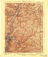
 1948 Cumberland1948 Print · USGSMid-century Appalachia and the Shenandoah Valley are shown in detail, documenting the industrial and transportation hubs of the tri-state area. Genealogists can trace family roots through settlements like Double Tollgate and Bunker Hill or along the Baltimore & Ohio RR.3 unique versions available
 - 1949 Map of Clarksburg
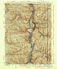
 1949 Clarksburg1949 Print · USGSThe upper Ohio River valley and the industrial heart of West Virginia come into focus during this post-war period. Genealogists and researchers can trace the rail corridors of the Baltimore and Ohio and locate centers like Fairmont, Grafton, and Waynesburg.
End of results
Showing maps 1-6 of 6
Top cities of Washington County
- Washington historical maps
- Cecil Township historical maps
- Canonsburg historical maps
- South Strabane Township historical maps
- California historical maps
- Charleroi historical maps
See more
Frequently asked questions
- What are the different types of historical maps available for Washington County?
- What is the oldest map of Washington County?
- Where can I purchase historical maps of Washington County for my home or office?
- Where can I download high-res historical maps of Washington County?
- Are there historical topographic maps available for Washington County?
- Is there historical aerial imagery available for Washington County?
- Where are historical maps of Washington County sourced from?