Old Maps of Washington County, Pennsylvania for Hiking & Exploration
Hike through history with 251 historic maps of Washington County. Explore old trails, ghost towns, and forgotten backroads — perfect for outdoor adventurers and local explorers.
- Rediscover forgotten places: Map out old mining camps, roads, and footpaths that no longer exist on modern maps.
- Layer with modern tools: Combine with LiDAR or satellite views to plan hikes through historical terrain.
- Made for exploration: Popular among hikers, overlanders, and local history lovers.
Use these maps to find adventure and explore the hidden past of Washington County.
Washington County, PA maps
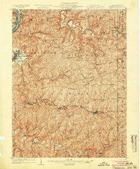
(251)- 1900 Map of Masontown
 1900 Masontown1900 Print · USGSThe Monongahela River valley was a hub of transit and industry at the turn of the century, defined by its numerous ferry crossings and coal-country junctions. Researchers can trace historic river crossings like McCanns Ferry, follow the National Pike, and locate vanished rail stops at Ache Junction.
 - 1901 Map of Amity, 1956 Print
 1901 Amity1956 Print · USGSWashington County at the turn of the century shows a landscape transitioning between historic pikes and the burgeoning rail era. Researchers can trace ancestral property near Tenmile Creek or follow the route of the National Pike through Laboratory and Zediker.
 - 1901 Map of Waynesburg, 1958 Print
 1901 Waynesburg1958 Print · USGSGreene County at the start of the twentieth century shows a landscape of deep valleys and rising townships connected by the South Fork of Tenmile Creek. Genealogists can trace family names through landmarks like Rees Mill, Gump, and the dual settlement of Kirby Newtown.
 - 1902 Map of Wheeling
 1902 Wheeling1902 Print · USGSThe Ohio River valley at the start of the 1900s was a powerhouse of rail and river industry across West Virginia, Ohio, and Pennsylvania. Genealogists can trace family roots in early industrial hubs like Martins Ferry, locate historic landmarks like the S Bridge, or find riverfront settlements such as Beach Bottom and Yorkville.7 unique versions available
 - 1902 Map of Brownsville
 1902 Brownsville1902 Print · USGSThe Monongahela Valley was a powerhouse of Pennsylvania industry at the start of the twentieth century, defined by its coal mines and river-front rail lines. Researchers can trace the heritage of the National Pike and locate vanished works at Vesta Mine or Coal Bluff.
 - 1903 Map of Masontown
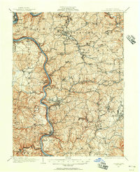
 1903 Masontown1903 Print · USGSThe Monongahela River valley at the turn of the century was a vital artery of ferries and river locks connecting Fayette and Greene Counties. Genealogists and local historians can trace family roots through riverfront landings and towns like Greensboro, Masontown, and Smithfield.4 unique versions available
 - 1904 Map of Amity
 1904 Amity1904 Print · USGSWashington County at the start of the twentieth century was a bustling nexus of rail and road, centered on the growing city of WASHINGTON. Researchers can trace early property lines and rail stops like Meadowlands, Laboratory, and the Pittsburg and Washington Turnpike.6 unique versions available
 - 1904 Map of Steubenville
 1904 Steubenville1904 Print · USGSThe industrial heart of the Ohio River Valley comes to life in this early 1900s survey of the tri-state border region. Genealogists and historians can trace the early footprints of Steubenville, the rail junctions at Mingo Junction, and river crossings like Middle Ferry.5 unique versions available
 - 1904 Map of Mc Keesport
 1904 Mc Keesport1904 Print · USGSAllegheny County at the height of its industrial era reveals a landscape of massive rail yards and riverfront steel towns. Genealogists can trace family roots through dense neighborhoods in Homestead, Wilkinsburg, and Braddock or locate ancestral plots in Homewood Cem.2 unique versions available
 - 1904 Map of Waynesburg
 1904 Waynesburg1904 Print · USGSGreene County was a landscape of deeply carved creek valleys and rural crossroads at the start of the twentieth century. Genealogists and local historians can trace early property settings near Waynesburg, Rees Mill, and the riverside borough of Rices Landing.5 unique versions available
 - 1904 Map of Cameron
 1904 Cameron1904 Print · USGSMarshall County's river-and-rail economy is frozen in time at the dawn of the century, showing the dense settlement patterns of the West Virginia panhandle. Researchers can trace the Baltimore and Ohio R R through Rosbys Rock or locate rural landmarks like Beelers Station and the Waynesburg Turnpike.4 unique versions available
 - 1904 Map of Carnegie, 1954 Print
 1904 Carnegie1954 Print · USGSAllegheny County's industrial heartland is captured here at the start of the twentieth century as rail lines and mines reshaped the landscape. Researchers can trace early settlements and social hubs like Cliff Mine, the County Home, and the Union Church.
 - 1904 Map of Burgettstown, 1958 Print
 1904 Burgettstown1958 Print · USGSWashington County and its neighbors are documented at the turn of the century as the coal and rail industries began reshaping the landscape. Researchers can trace early family sites and infrastructure from Pattersons Mill to the Francis Mine and the North Star Tyre P O.
 - 1905 Map of Rogersville
 1905 Rogersville1905 Print · USGSGreene and Washington counties are documented here at the turn of the century as a maze of ridge-and-valley settlements. Genealogists can trace early homesteads and commerce hubs like Harveys P.O. Graysville, Simpson Store, and Ryerson Station.4 unique versions available
 - 1906 Map of Brownsville
 1906 Brownsville1906 Print · USGSSouthwestern Pennsylvania’s river valleys were centers of industrial expansion when this survey was conducted. Genealogists can locate family homes and landmarks in riverfront towns like Monessen and Charleroi, or trace rural roots near Salem Church and Ginger Hill.4 unique versions available
 - 1906 Map of Burgettstown
 1906 Burgettstown1906 Print · USGSWestern Pennsylvania’s coal and rail landscape comes into focus at the dawn of the twentieth century. Researchers can trace historic family landmarks and industrial sites like Francis Mine, Pattersons Mill, and the North Star Tyre P O.5 unique versions available
 - 1906 Map of Carnegie
 1906 Carnegie1906 Print · USGSThe industrial valleys of Western Pennsylvania come alive in the early 1900s, showing the early infrastructure of the Ohio River and its tributaries. Local historians can trace family roots at Union Church or explore the early coal economy at Cliff Mine and Walkers Mills.7 unique versions available
 - 1907 Map of Pittsburg
 1907 Pittsburg1907 Print · USGSSteel-industry heartlands and river-valley rail corridors define the Pittsburgh region in the early nineteen-hundreds. Trace the complex rail networks of the Union RR and Pennsylvania RR through industrial hubs like Homestead and Wilmerding.10 unique versions available
 - 1907 Map of Claysville
 1907 Claysville1907 Print · USGSWashington County during the first decade of the 1900s shows a dense network of hill-country townships connected by the Baltimore and Ohio RR. Researchers can trace rural life through numerous named schoolhouses and local post offices like Crothers PO and Vienna Coon Island PO.5 unique versions available
 - 1908 Map of Carnegie, 1910 Print
 1908 Carnegie1910 Print · USGSSouthwest of the Pittsburgh river forks in the early 1900s, a complex web of railroads and industrial hollows began to link the rural coal and mill towns. Trace the paths of the Wabash and Side Belt lines past landmarks like Cliff Mine, Guy Mills, and Treveskyn Cuddy PO.
 - 1931 Map of Brownsville, 1954 Print
 1931 Brownsville1954 Print · USGSThe industrial Monongahela and Youghiogheny river valleys are captured here in the early thirties, showcasing a landscape of coal mines and river locks. Genealogists can trace family homes near Vesta Mine, Sutersville, and rural landmarks like Salem Church.
 - 1931 Map of Masontown, 1957 Print
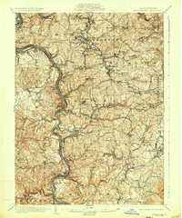
 1931 Masontown1957 Print · USGSFayette County’s industrial landscape is captured here during the 1930s, showing the high-water mark of the regional coal and coke era. Genealogists and historians can trace company towns and numbered mines like Tower Hill No 1 and Thompson No 2 alongside river crossings like Crows Ferry.
 - 1933 Map of Brownsville
 1933 Brownsville1933 Print · USGSWestern Pennsylvania’s industrial heartland thrives along the river bends in the early thirties, where coal and rail define the landscape. Trace the expansion of river towns like Charleroi and Monessen, locate the Vesta Mine, or find rural landmarks like Mt Union Sch.2 unique versions available
 - 1935 Map of Masontown
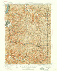
 1935 Masontown1935 Print · USGSFayette and Greene Counties come alive in the 1930s as the river-and-rail economy of the Monongahela Valley reaches its peak. Genealogists can trace family roots through numerous country schools like Christopher Sch and historic sites such as Friendship Hill.2 unique versions available
 - 1935 Map of Cameron, 1957 Print
 1935 Cameron1957 Print · USGSMarshall County in the mid-thirties was a landscape of deep hollows and high ridges linked by the Baltimore and Ohio RR. Genealogists and historians can locate dozens of country institutions like Wood Hill Ch, Beeler's Station, and Adaline Sch during the era of one-room schoolhouses.2 unique versions available
Showing maps 1-25 of 251
Top cities of Washington County
- Washington historical maps
- Cecil Township historical maps
- Canonsburg historical maps
- South Strabane Township historical maps
- California historical maps
- Charleroi historical maps
See more
Frequently asked questions
- What are the different types of historical maps available for Washington County?
- What is the oldest map of Washington County?
- Where can I purchase historical maps of Washington County for my home or office?
- Where can I download high-res historical maps of Washington County?
- Are there historical topographic maps available for Washington County?
- Is there historical aerial imagery available for Washington County?
- Where are historical maps of Washington County sourced from?