1990s Maps of Washington County, Pennsylvania
Explore 14 historic maps of Washington County from the 1990s. These maps offer a rare glimpse into what life looked like during the 1990s — showing old roads, neighborhoods, homes, and landmarks that have changed or disappeared over time.
Whether you're researching your family's past, planning a metal detecting trip, or studying how Washington County's landscape evolved across the 1990s, these high-resolution maps are a powerful tool for exploring the history of this region.
- Focus on a specific era: All maps on this page are from the 1990s, giving you a focused view of this time period.
- See what’s changed: Compare century-old streets, trails, and buildings to today's modern landscape using overlays and satellite layers.
- Research with precision: Use these maps for genealogy, historical research, land use analysis, or educational projects.
- View, download, or print: Maps are fully viewable online in high resolution, and can be downloaded or printed for your own records.
Start exploring Washington County's history through authentic maps from the 1990s. This is your window into the past.
Washington County, PA maps
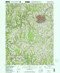
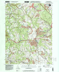
(14)- 1993 Map of Donora
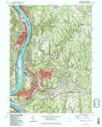
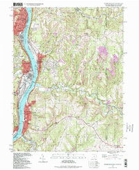
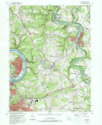 1993 Donora1993 Print · USGSThe industrial river valleys of the Monongahela and Youghiogheny are captured in the early nineties as they balance legacy industry with growing suburbs. Genealogists can trace family roots through sites like Douglass Cem, Apples Mill Ch, and the Concord Pioneer Sch.2 unique versions available
 - 1993 Map of Monongahela, 1999 Print
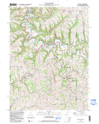
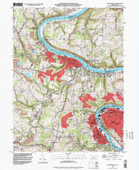 1993 Monongahela1999 Print · USGSThe industrial Monongahela Valley is captured in the early nineties, showing a landscape shaped by river commerce and mining. Researchers can trace family roots at Taylor Cem or locate historic landmarks like Shire Oaks and Hazel Kirk.
 - 1993 Map of Bridgeville, 1999 Print
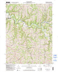
 1993 Bridgeville1999 Print · USGSSouth of Pittsburgh in the early nineties, these hills show a landscape of maturing suburbs and industrial remnants. Trace local history at St Francis Academy, Anne Siding, and the sprawling Queen of Heaven Cemetery.
 - 1993 Map of Hackett, 1999 Print
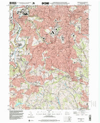
 1993 Hackett1999 Print · USGSThe hill country of Washington County appears in the late twentieth century as a landscape of deep-rooted rural townships and legacy coal mining. Researchers can trace family sites at Munnstown Cem, locate the Thomas Tunnel, or explore settlements like Venetia and Bentleyville.
 - 1993 Map of Oakdale, 1999 Print
 1993 Oakdale1999 Print · USGSAllegheny County in the early 1990s shows a landscape defined by industrial legacy and the growth of the Greater Pittsburgh International Airport. Genealogists and historians can trace local family roots through sites like Resurrection Cemetery, Cliff Mine, and the Montour RR corridor.
 - 1993 Map of Washington West, 1999 Print
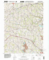
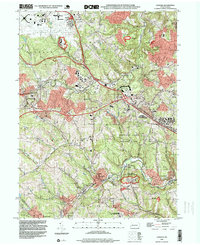
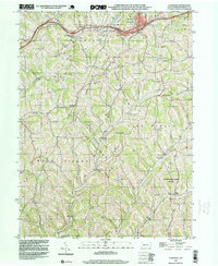
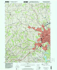 1993 Washington West1999 Print · USGSWashington and its western suburbs appear in the early nineties, revealing a landscape where industrial heritage meets suburban growth. Researchers can trace historic sites like Arden Mines, the Childrens Home, and the rural Taylorstown Sta.
 - 1994 Map of Weirton, 1998 Print
 1994 Weirton1998 Print · USGSThe Ohio River valley at the close of the 20th century shows a landscape defined by heavy industry and established riverfront towns. Genealogists and researchers can trace local roots through landmarks like Hollidays Cove, Union Cem, and Roosevelt Sch.
 - 1997 Map of Steubenville East, 1999 Print
 1997 Steubenville East1999 Print · USGSThe industrial Ohio River valley is captured here in the late twentieth century, showing the dense riverside settlements of Steubenville and Follansbee. Researchers can trace local genealogy and land use through numerous hillside burial grounds like Oak Grove Cem and Cross Creek Cem.
 - 1997 Map of Wind Ridge, 1999 Print
 1997 Wind Ridge1999 Print · USGSSouthwestern Pennsylvania's rural hill country is mapped here in the late nineties, showing the transition between Greene and Washington counties. Genealogists can locate family burial grounds like Zollars Cem and trace the area surrounding the Jacktown Fairgrounds.
 - 1997 Map of Bethany, 2000 Print
 1997 Bethany2000 Print · USGSThe West Virginia panhandle near the Pennsylvania line is home to storied campuses and deep-seated rural traditions. Researchers can find prominent landmarks like Bethany College, the historic Alexander Campbell Mansion, and the Lower Buffalo Cem.
 - 1997 Map of Valley Grove, 2000 Print
 1997 Valley Grove2000 Print · USGSThe West Virginia and Pennsylvania borderlands come alive in the late nineties, centered on the historic National Road corridor. Trace family roots at West Alexander and Triadelphia, or locate the old County Home and Sanatorium.
 - 1997 Map of Majorsville, 2000 Print
 1997 Majorsville2000 Print · USGSThe West Virginia and Pennsylvania borderlands come into focus in the late nineties, documenting the high ridges and deep hollows of Marshall County. Genealogists can trace family footprints through sites like Beelers Station Ch, Earlywine Cem, and the vanished site of Crows Mills.
 - 1998 Map of Claysville, 1999 Print
 1998 Claysville1999 Print · USGSSouthwestern Pennsylvania’s rural heritage is preserved here in the late nineties, showcasing the ridge-and-valley landscape of Washington County. Researchers can trace the National Road and locate sites like Good Intent, St James Cem, and the East West Finley Sch.
 - 1998 Map of Clinton, 2000 Print
 1998 Clinton2000 Print · USGSWestern Pennsylvania at the end of the century reveals a landscape shaped by heavy industry and aviation. Researchers can trace family sites near Hebron Ch, explore the footprint of Imperial, or study the impact of Reclaimed Strip Mines and the Greater Pittsburgh International Airport.
End of results
Showing maps 1-14 of 14
Top cities of Washington County
- Washington historical maps
- Cecil Township historical maps
- Canonsburg historical maps
- South Strabane Township historical maps
- California historical maps
- Charleroi historical maps
See more
Frequently asked questions
- What are the different types of historical maps available for Washington County?
- What is the oldest map of Washington County?
- Where can I purchase historical maps of Washington County for my home or office?
- Where can I download high-res historical maps of Washington County?
- Are there historical topographic maps available for Washington County?
- Is there historical aerial imagery available for Washington County?
- Where are historical maps of Washington County sourced from?