1960s Maps of Washington County, Pennsylvania
Explore 19 historic maps of Washington County from the 1960s. These maps offer a rare glimpse into what life looked like during the 1960s — showing old roads, neighborhoods, homes, and landmarks that have changed or disappeared over time.
Whether you're researching your family's past, planning a metal detecting trip, or studying how Washington County's landscape evolved across the 1960s, these high-resolution maps are a powerful tool for exploring the history of this region.
- Focus on a specific era: All maps on this page are from the 1960s, giving you a focused view of this time period.
- See what’s changed: Compare century-old streets, trails, and buildings to today's modern landscape using overlays and satellite layers.
- Research with precision: Use these maps for genealogy, historical research, land use analysis, or educational projects.
- View, download, or print: Maps are fully viewable online in high resolution, and can be downloaded or printed for your own records.
Start exploring Washington County's history through authentic maps from the 1960s. This is your window into the past.
Washington County, PA maps
(19)- 1960 Map of Oakdale
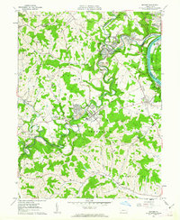
 1960 Oakdale1960 Print · USGSAllegheny County during the expansion of the mid-century reveals a landscape caught between the industrial past and the modern jet age. Genealogists and local historians can trace the footprint of coal at Cliff Mine, institutional history at Woodville State Hospital, and early aviation at the Greater Pittsburgh Airport.7 unique versions available
 - 1960 Map of Bridgeville, 1961 Print
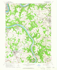
 1960 Bridgeville1961 Print · USGSAllegheny and Washington counties are captured at a peak of suburban growth in the early sixties. Genealogists and local historians can trace the foundations of Castle Shannon and Bridgeville, or locate family sites near St Casimir Cem and Mayview State Hospital.6 unique versions available
 - 1960 Map of Canonsburg, 1961 Print
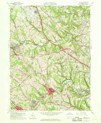
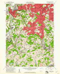
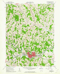
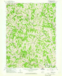
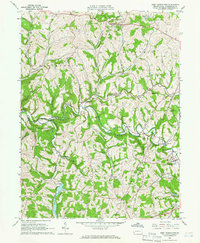
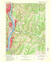
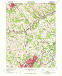 1960 Canonsburg1961 Print · USGSWashington County at the start of the sixties reveals a landscape of deep coal heritage and industrial rail hubs. Genealogists and historians can trace the foundations of Canonsburg and Houston or locate rural landmarks like St Marys Cem and Ship Mine.5 unique versions available
 - 1960 Map of Glassport, 1961 Print
 1960 Glassport1961 Print · USGSThe industrial Monongahela Valley comes alive in this 1960s survey, showing the peak of the rail-and-river economy from Mc Keesport to Elizabeth. Genealogists and historians can trace family sites at Cochrans Mill, Snowden, and the Jefferson Mem Cem.4 unique versions available
 - 1961 Map of Clarksburg
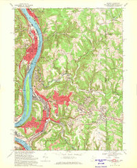
 1961 Clarksburg1961 Print · USGSThe mid-century industrial and river landscapes of West Virginia and Ohio are detailed here, centered on the Ohio River. Researchers can trace the Baltimore and Ohio rail lines connecting towns like Parkersburg, Clarksburg, and Monongah.
 - 1961 Map of Cumberland
 1961 Cumberland1961 Print · USGSThe tri-state highlands of Maryland, West Virginia, and Pennsylvania are shown in the mid-twentieth century as a complex landscape of ridges and river valleys. Researchers can trace the winding Potomac River and find old rail-and-river towns like Cumberland, Keyser, and Morgantown.
 - 1961 Map of Waynesburg, 1963 Print
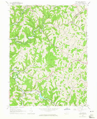
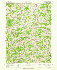
 1961 Waynesburg1963 Print · USGSMid-century Greene County comes to life in this detailed survey centered on the collegiate town of Waynesburg. Researchers can locate family sites at Green Mount Cem, trace the local coal landscape at Grimes Portal, or find the old Drive-in Theater.4 unique versions available
 - 1961 Map of Mather, 1963 Print
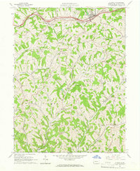
 1961 Mather1963 Print · USGSThe industrial coal and river economy of Greene County is on full display in the early 1960s. Researchers can trace the layout of mining-era housing like Braden Plan, locate the Emerald Mine, or find ancestors at Pollock Cem and Mt Zion Cem & Ch.3 unique versions available
 - 1962 Map of Cumberland
 1962 Cumberland1962 Print · USGSThe central Appalachians meet at the height of the mid-century industrial era, showing the rugged topography between Morgantown and Winchester. Genealogists can trace family lands near Fort Necessity or along the vital Baltimore & Ohio RR corridors.
 - 1962 Map of Canton
 1962 Canton1962 Print · USGSThe industrial heartland of Eastern Ohio and Western Pennsylvania thrives in the early sixties as steel mills and rail lines dominate the river valleys. Genealogists and historians can trace local landmarks like McKinley National Memorial, Malone College, and industrial sites such as Republic Steel Corp.2 unique versions available
 - 1964 Map of Pittsburgh
 1964 Pittsburgh1964 Print · USGSWestern Pennsylvania in the late fifties and early sixties shows a landscape of powerful river industries and expanding highways. Genealogists and historians can trace the rail corridors of the Pennsylvania RR through industrial hubs like Johnstown, Altoona, and Nanty Glo.
 - 1964 Map of Carmichaels, 1965 Print
 1964 Carmichaels1965 Print · USGSSouthwestern Pennsylvania's coal and river corridor is captured here in the mid-1960s during a period of intense industrial activity. Genealogists and historians can trace the intricate layouts of company towns like Crucible, Nemacolin, and Republic, or locate rural landmarks such as Hopewell Ch and the Township High Sch.5 unique versions available
 - 1964 Map of Rogersville, 1965 Print
 1964 Rogersville1965 Print · USGSGreene County entered the mid-sixties with a landscape defined by its deep creek valleys and a growing network of gas and oil infrastructure. Researchers can locate dozens of Gas Wells, the historic Covered Bridge, and community anchors like Nineveh and Beulah Ch.4 unique versions available
 - 1964 Map of Wind Ridge, 1965 Print
 1964 Wind Ridge1965 Print · USGSGreene and Washington Counties are shown in the mid-sixties as a rural landscape of winding forks and deep-rooted small communities. Genealogists and local historians can locate family landmarks like Simpson Store, the Jacktown Fairgrounds, and several Covered Bridges.3 unique versions available
 - 1964 Map of West Middletown, 1966 Print
 1964 West Middletown1966 Print · USGSWashington County during the mid-1960s shows a landscape of deep valleys and hilltop hamlets as the region’s energy infrastructure expanded. Researchers can find numerous family-named landmarks and old rural congregations, including the Mt Hope Ch, Hupp Cem, and a historic Covered Bridge on Buffalo Creek.3 unique versions available
 - 1964 Map of Prosperity, 1966 Print
 1964 Prosperity1966 Print · USGSSouthern Washington County is captured here in the mid-1960s, showing a landscape of deep valleys and hilltop farms. Researchers can trace old family sites near South Buffalo Cem or find local landmarks like the Covered Bridge and Prosperity Township Sch.3 unique versions available
 - 1964 Map of Claysville, 1966 Print
 1964 Claysville1966 Print · USGSThe northern Washington County countryside was defined by the historic National Road and energy development in the 1960s. Family historians can trace small communities like Coon Island and Good Intent, alongside local landmarks like St James Cem and the East-West Finley Sch.3 unique versions available
 - 1968 Map of Weirton, 1970 Print
 1968 Weirton1970 Print · USGSThe industrial corridor along the Ohio River is shown here at its mid-century peak during the late sixties. Genealogists and local historians can trace family locations through Union Cem, Sacred Heart of Mary Ch, and numerous neighborhood schools like Roosevelt Sch.3 unique versions available
 - 1968 Map of Steubenville East, 1970 Print
 1968 Steubenville East1970 Print · USGSThe Ohio River valley was a bustling hub of industry and transit in the late sixties, where West Virginia and Ohio river towns met. Genealogists can trace family footprints through sites like St Johns Cem, the Lower Buffalo Ch, and Mingo Junction.3 unique versions available
End of results
Showing maps 1-19 of 19
Top cities of Washington County
- Washington historical maps
- Cecil Township historical maps
- Canonsburg historical maps
- South Strabane Township historical maps
- California historical maps
- Charleroi historical maps
See more
Frequently asked questions
- What are the different types of historical maps available for Washington County?
- What is the oldest map of Washington County?
- Where can I purchase historical maps of Washington County for my home or office?
- Where can I download high-res historical maps of Washington County?
- Are there historical topographic maps available for Washington County?
- Is there historical aerial imagery available for Washington County?
- Where are historical maps of Washington County sourced from?