Old Maps of Antelope Segment, South Dakota for Metal Detecting
Plan your next treasure hunt with 93 historic maps of Antelope Segment. Find old homesites, ghost towns, trails, and gathering spots that may be lost to time — perfect for identifying promising metal detecting locations.
- Locate forgotten sites: Uncover places like long-lost settlements, abandoned rail lines, or gathering spots.
- Plan better hunts: Use map overlays combined with LiDAR or satellite views to narrow in on historically rich areas.
- Made for detectorists: Thousands of hobbyists use these maps to discover relics, coins, and hidden history.
Use these historic maps to boost your research and find new opportunities beneath the surface of Antelope Segment.
Antelope Segment, SD maps
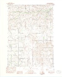
(93)- 1950 Map of Sparks, 1952 Print
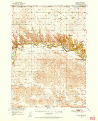 1950 Sparks1952 Print · USGSThe Niobrara River canyon cuts through Cherry County during the mid-twentieth century, revealing a landscape of remote ranches and conservation lands. Researchers can trace the Chicago and North Western rail line and locate rural landmarks like Smith Falls, Bryant Ranch, and several numbered schoolhouses.3 unique versions available
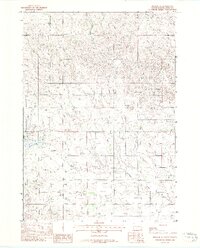
 - 1950 Map of Valentine, 1952 Print
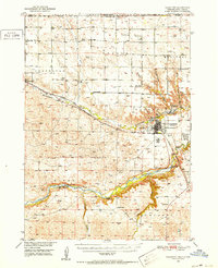 1950 Valentine1952 Print · USGSThe ranching and rail country of Cherry County comes alive in this 1950s record of Valentine and its surrounding prairie. Researchers can locate early one-room schoolhouses like Ward School, family landmarks like Heth Ranch, and the path of the Chicago and North Western railroad.2 unique versions available
 - 1955 Map of Martin, 1968 Print
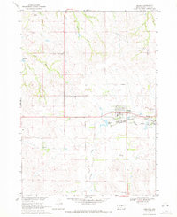
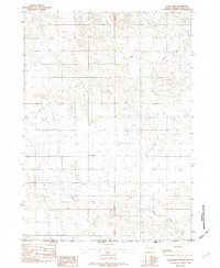
 1955 Martin1968 Print · USGSTribal lands and rail corridors define the South Dakota plains in the mid-fifties, from the sand hills to the badlands. Genealogists and historians can trace the early layout of Pine Ridge Indian Reservation settlements and find small rail towns like Stamford and Witten.2 unique versions available
 - 1957 Map of Valentine, 1960 Print
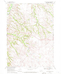
 1957 Valentine1960 Print · USGSNorthern Nebraska's ranching country and the vast Sand Hills are detailed here in the late fifties. Genealogists and historians can locate numerous family-named landmarks like the Dahlgren Ranch and trace the path of the Chicago and North Western railroad through Valentine.3 unique versions available
 - 1958 Map of Martin
 1958 Martin1958 Print · USGSSouth Dakota's southern plains are documented here in the late fifties, showing the expansive Pine Ridge and Rosebud Indian Reservations. Genealogists and historians can locate early settlements along the Chicago Milwaukee St Paul and Pacific line or find family roots near Martin and the Indian Cemetery.
 - 1959 Map of Valentine
 1959 Valentine1959 Print · USGSThe northern Nebraska Sand Hills are captured here in the late fifties, showcasing a vast ranching landscape shaped by the Niobrara and Loup rivers. Genealogists and historians can trace rail-town development along the Chicago and North Western and locate remote outposts like Brownlee or Kennedy.
 - 1969 Map of Soldier Creek NE, 1971 Print
 1969 Soldier Creek NE1971 Print · USGSThe South Dakota prairie meets the winding Little White River in the late sixties along the Rosebud Indian Reservation. Genealogists and researchers can trace local family landmarks like Ring Thunder Sacred Heart Cem and St John Cem across the northern plains.
 - 1969 Map of Mission NW, 1971 Print
 1969 Mission NW1971 Print · USGSThe rural prairie landscape of Mellette County was surveyed in the late 1960s as it appeared before many modern shifts. Genealogists and researchers can trace community landmarks like St James Chapel, Body of Christ Cem, and the Neville Sch near the Horse Creek drainage.
 - 1969 Map of Mission, 1971 Print
 1969 Mission1971 Print · USGSTodd County and the Rosebud Indian Reservation are shown during a period of steady prairie development in the late sixties. Researchers can trace family sites at the Indian Mission Cem or Trinity Cem, and locate landmarks like Mission Sioux Airport and Table Butte.
 - 1969 Map of Soldier Creek SE, 1972 Print
 1969 Soldier Creek SE1972 Print · USGSThe Rosebud Indian Reservation in the late sixties shows a landscape where spiritual and cultural sites are vital landmarks. Genealogists and historians can trace local heritage through the Native American Cem, Ring Thunder Ch, and the area around Swift Bear Lake.
 - 1969 Map of Olsonville NW, 1972 Print
 1969 Olsonville NW1972 Print · USGSTodd County, South Dakota is mapped in the late sixties, showing the vital relationship between the land and its water sources within the Rosebud Indian Reservation. Genealogists and historians can trace field boundaries and vital water points like Antelope Creek, Well, and Spring.
 - 1969 Map of Olsonville SW, 1972 Print
 1969 Olsonville SW1972 Print · USGSThe South Dakota-Nebraska borderlands within the Rosebud Indian Reservation are shown in detail during the late sixties. Genealogists can locate legacy sites like Lakeview Cem, St Agnes Cem, and the community of Lakeview.
 - 1982 Map of Mission NE
 1982 Mission NE1982 Print · USGSMellette and Todd Counties at the start of the 1980s reveal a landscape of vast ranchlands and reservation geography. Local history researchers can pinpoint family holdings like Gifford Ranch and Lauritsen Ranch along the banks of White Thunder Creek.
 - 1982 Map of Olsonville
 1982 Olsonville1982 Print · USGSTodd County’s high plains and the Rosebud Indian Reservation are documented here during the early eighties. Researchers can trace the layout of Olsonville and the winding course of Lone Tree Creek and Rock Creek across the prairie landscape.
 - 1982 Map of Olsonville SE
 1982 Olsonville SE1982 Print · USGSThe South Dakota and Nebraska borderlands are captured in the early eighties, showing the quiet transition between Todd Co and Cherry Co. Researchers can trace the natural drainage patterns of Rock Creek and smaller seasonal Creek beds across the prairie landscape.
 - 1982 Map of Hidden Timber
 1982 Hidden Timber1982 Print · USGSTodd County's high plains terrain is documented here in the early eighties as the landscape of the Rosebud Reservation remained largely open. Genealogists and local historians can locate rural landmarks like Hidden Timber and Klein Sch along the Keya Paha River.
 - 1982 Map of Okreek
 1982 Okreek1982 Print · USGSThe community of Okreek is captured in the early eighties as it serves the surrounding Rosebud Indian Reservation. Researchers can trace the layout of the settlement, identifying local landmarks like St Peters Ch and the Post Office along the banks of Oak Creek.
 - 1982 Map of Mission SE
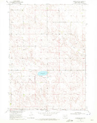
 1982 Mission SE1982 Print · USGSTodd County, South Dakota, in the early 1980s reveals the water-carved landscape of the Rosebud Indian Reservation. Researchers can trace the drainages of Antelope Creek and White Thunder Creek or locate the settlement at Antelope near the shores of Antelope Lake.
 - 1982 Map of Wood South
 1982 Wood South1982 Print · USGSThe northern edge of the Rosebud Reservation comes into focus during the early 1980s, centered on the community of Wood. Researchers can trace local landmarks and burial sites like the Grandstand Rodeo Arena, Evergreen Cem, and Rattlesnake Butte.
 - 1982 Map of Littleburg
 1982 Littleburg1982 Print · USGSThe South Dakota and Nebraska borderlands are captured here in the early 1980s, centered on the settlement of Littleburg. Local historians can trace the Indian Reservation Boundary and follow the natural drainages of Eagle Creek and Sand Creek.
 - 1982 Map of Mission, 1983 Print
 1982 Mission1983 Print · USGSThe Rosebud Reservation in the early eighties shows a landscape of plains communities and aviation outposts. Genealogists and researchers can trace local centers like Mission, Rosebud, and St Francis, or locate family landmarks near Antelope Lake and the Keya Paha River.
 - 1983 Map of Crookston East, 1984 Print
 1983 Crookston East1984 Print · USGSThe Nebraska-South Dakota borderlands are captured here in the early 1980s, centered on the Rosebud Indian Reservation. Researchers can trace the Chicago and North Western railroad as it passes through Crookston and follows the bends of Minnechadua Creek.
 - 1983 Map of Valentine North, 1984 Print
 1983 Valentine North1984 Print · USGSThe northern Nebraska borderlands and Rosebud Indian Reservation meet at the turn of the 1980s. Genealogists and historians can trace local landmarks like Richland Harmony Cem, the C & NW railroad, and the Valentine State Fish Hatchery.2 unique versions available
 - 1983 Map of Cornell Dam, 1984 Print
 1983 Cornell Dam1984 Print · USGSThe Nebraska-South Dakota borderlands along the Niobrara River are documented in the early 1980s, highlighting a significant conservation landscape. Historians can trace the infrastructure of the Cornell Dam and find landmarks like Fort Falls and the Rosebud Indian Res.
 - 1985 Map of Valentine
 1985 Valentine1985 Print · USGSThe Nebraska Sandhills in the mid-1980s reveal a landscape of vast wildlife refuges and rail-linked prairie towns. Researchers can trace the Chicago and North Western corridor through Kilgore and Valentine or locate remote landmarks like Snake River Falls.2 unique versions available
Showing maps 1-25 of 93
Top cities near Antelope Segment
Top neighborhoods of Antelope Segment
- Antelope Development Area historical maps
- Lakeview historical maps
- Littleburg historical maps
- Olsonville historical maps
- Rosebud historical maps
- Sicangu Village historical maps
See more
Frequently asked questions
- What are the different types of historical maps available for Antelope Segment?
- What is the oldest map of Antelope Segment?
- Where can I purchase historical maps of Antelope Segment for my home or office?
- Where can I download high-res historical maps of Antelope Segment?
- Are there historical topographic maps available for Antelope Segment?
- Is there historical aerial imagery available for Antelope Segment?
- Where are historical maps of Antelope Segment sourced from?