1920s Maps of Angelina County, Texas
Explore 3 historic maps of Angelina County from the 1920s. These maps offer a rare glimpse into what life looked like during the 1920s — showing old roads, neighborhoods, homes, and landmarks that have changed or disappeared over time.
Whether you're researching your family's past, planning a metal detecting trip, or studying how Angelina County's landscape evolved across the 1920s, these high-resolution maps are a powerful tool for exploring the history of this region.
- Focus on a specific era: All maps on this page are from the 1920s, giving you a focused view of this time period.
- See what’s changed: Compare century-old streets, trails, and buildings to today's modern landscape using overlays and satellite layers.
- Research with precision: Use these maps for genealogy, historical research, land use analysis, or educational projects.
- View, download, or print: Maps are fully viewable online in high resolution, and can be downloaded or printed for your own records.
Start exploring Angelina County's history through authentic maps from the 1920s. This is your window into the past.
Angelina County, TX maps
(3)- 1927 Map of Lufkin 4-c
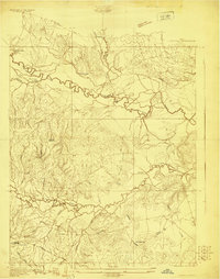 1927 Lufkin 4-c1927 Print · USGSDeep in the Piney Woods during the late twenties, this survey documents the winding Neches River and the rural communities of Polk County. Researchers can locate the Pluck PO, Seaman Ridge Sch, and the path of the Beaumont Trinity and Sabine.
 - 1928 Map of Zavalla 3-c
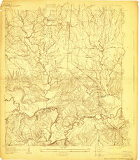 1928 Zavalla 3-c1928 Print · USGSThe timber-driven landscape of East Texas is captured here in the late twenties along the winding Neches River. Researchers can trace the paths of old logging lines like the Lumber RR Switch and find rural community hubs like Rockland, Nancy, and the Saron Sch.
 - 1928 Map of Lufkin 4-d
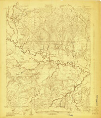 1928 Lufkin 4-d1928 Print · USGSDeep in the East Texas bottomlands during the late 1920s, the river systems dictate the shape of local life and county lines. Genealogists can trace family footprints near Lambert Chapel or the rural Crane Sch and Delview Sch.
End of results
Showing maps 1-3 of 3
Top cities of Angelina County
- Lufkin historical maps
- Diboll historical maps
- Hudson historical maps
- Huntington historical maps
- Redland historical maps
- Burke historical maps
See more
Frequently asked questions
- What are the different types of historical maps available for Angelina County?
- What is the oldest map of Angelina County?
- Where can I purchase historical maps of Angelina County for my home or office?
- Where can I download high-res historical maps of Angelina County?
- Are there historical topographic maps available for Angelina County?
- Is there historical aerial imagery available for Angelina County?
- Where are historical maps of Angelina County sourced from?