1960s Maps of Angelina County, Texas
Explore 7 historic maps of Angelina County from the 1960s. These maps offer a rare glimpse into what life looked like during the 1960s — showing old roads, neighborhoods, homes, and landmarks that have changed or disappeared over time.
Whether you're researching your family's past, planning a metal detecting trip, or studying how Angelina County's landscape evolved across the 1960s, these high-resolution maps are a powerful tool for exploring the history of this region.
- Focus on a specific era: All maps on this page are from the 1960s, giving you a focused view of this time period.
- See what’s changed: Compare century-old streets, trails, and buildings to today's modern landscape using overlays and satellite layers.
- Research with precision: Use these maps for genealogy, historical research, land use analysis, or educational projects.
- View, download, or print: Maps are fully viewable online in high resolution, and can be downloaded or printed for your own records.
Start exploring Angelina County's history through authentic maps from the 1960s. This is your window into the past.
Angelina County, TX maps
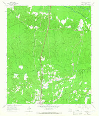
(7)- 1963 Map of Apple Springs, 1966 Print
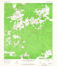 1963 Apple Springs1966 Print · USGSTrinity County timberlands and rural communities are captured here in the early 1960s. Researchers can locate family sites and landmarks like Mt Zion Cem, the settlement of Nigton, and the Mt Zion Lookout within the Davy Crockett National Forest.2 unique versions available
 - 1963 Map of Manning, 1966 Print
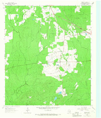 1963 Manning1966 Print · USGSAngelina County during the early 1960s reveals a landscape shaped by timber history and the Piney Woods environment. Trace the legacy of old logging lines along the Old RR Grade or locate family roots at Treadwell Cem and Manning.3 unique versions available
 - 1963 Map of Diboll, 1966 Print
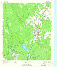 1963 Diboll1966 Print · USGSDiboll and the surrounding Angelina County timberlands are shown in the early sixties as the regional lumber industry flourished. Researchers can trace the junction of the Texas South-Eastern railroad, locate Clarks Ferry, or find family sites near McCarty Cem.2 unique versions available
 - 1963 Map of Wolf Hill, 1966 Print
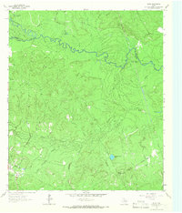
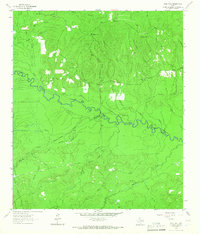 1963 Wolf Hill1966 Print · USGSDeep in the Piney Woods during the early sixties, the Neches River valley reveals a landscape of family-run cemeteries and old timber routes. Trace the Old Railroad Grade and find historic sites like Lambert Chapel or the Wolf Hill Lookout Tower.2 unique versions available
 - 1963 Map of Wakefield, 1966 Print
 1963 Wakefield1966 Print · USGSPolk County timberlands and river bottoms are documented here in the early sixties, showing the transition from old rail corridors to modern transit. Researchers can find Wakefield family landmarks, Knox Cem, and the path of the Southern Pacific railroad.3 unique versions available
 - 1963 Map of Pluck, 1966 Print
 1963 Pluck1966 Print · USGSThe bottomlands of the Neches River are captured here in the early sixties, showing a landscape defined by timber-era infrastructure and rural outposts. Genealogists can locate Grimes Cem and Stryker Cem while tracing the Old Railroad Grade near Pluck.2 unique versions available
 - 1963 Map of Bald Hill, 1966 Print
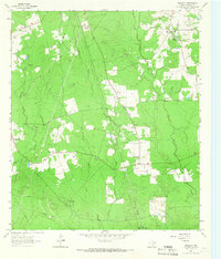 1963 Bald Hill1966 Print · USGSAngelina County in the early sixties is a landscape of rural communities and evolving industry set amidst the East Texas piney woods. Researchers can trace family roots at Gilbert Chapel or Pine Grove Ch and explore the path of an Old Railroad Grade near the Ginter Oil Field.2 unique versions available
End of results
Showing maps 1-7 of 7
Top cities of Angelina County
- Lufkin historical maps
- Diboll historical maps
- Hudson historical maps
- Huntington historical maps
- Redland historical maps
- Burke historical maps
See more
Frequently asked questions
- What are the different types of historical maps available for Angelina County?
- What is the oldest map of Angelina County?
- Where can I purchase historical maps of Angelina County for my home or office?
- Where can I download high-res historical maps of Angelina County?
- Are there historical topographic maps available for Angelina County?
- Is there historical aerial imagery available for Angelina County?
- Where are historical maps of Angelina County sourced from?