1950s Maps of Armstrong County, Texas
Explore 7 historic maps of Armstrong County from the 1950s. These maps offer a rare glimpse into what life looked like during the 1950s — showing old roads, neighborhoods, homes, and landmarks that have changed or disappeared over time.
Whether you're researching your family's past, planning a metal detecting trip, or studying how Armstrong County's landscape evolved across the 1950s, these high-resolution maps are a powerful tool for exploring the history of this region.
- Focus on a specific era: All maps on this page are from the 1950s, giving you a focused view of this time period.
- See what’s changed: Compare century-old streets, trails, and buildings to today's modern landscape using overlays and satellite layers.
- Research with precision: Use these maps for genealogy, historical research, land use analysis, or educational projects.
- View, download, or print: Maps are fully viewable online in high resolution, and can be downloaded or printed for your own records.
Start exploring Armstrong County's history through authentic maps from the 1950s. This is your window into the past.
Armstrong County, TX maps
(7)- 1954 Map of Amarillo, 1966 Print
 1954 Amarillo1966 Print · USGSThe Texas Panhandle in the mid-1960s shows a landscape of rising industrial power and deep-rooted ranching tradition. Local historians can trace the paths of the Panhandle and Santa Fe railroad or locate sites like the Pantex Ordnance Plant and Mobeetie.2 unique versions available
 - 1954 Map of Plainview, 1966 Print
 1954 Plainview1966 Print · USGSThe Texas Panhandle and the rugged Caprock Escarpment appear in detail as the region's agricultural and rail networks reached their mid-century peak. Trace family roots and old land patterns through the canyons and plains near Plainview, Palo Duro State Park, and Childress.3 unique versions available
 - 1956 Map of Fortress Cliff, 1957 Print
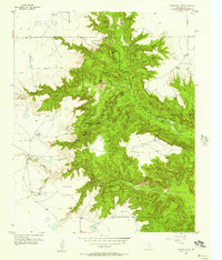 1956 Fortress Cliff1957 Print · USGSPalo Duro Canyon’s geological landmarks and early park infrastructure are captured here in the mid-fifties. Researchers can trace historic landmarks like Lighthouse Peak, the Historical Battle Site Marker, and the route of the Miniature Railroad.4 unique versions available
 - 1956 Map of Washburn, 1957 Print
 1956 Washburn1957 Print · USGSThe Texas Panhandle comes alive in the mid-1950s at the vital rail crossing of Washburn, where two major lines met the legendary Route 66. Genealogists and rail historians can trace the local Washburn Cem and the busy junction of the Fort Worth and Denver and the Rock Island railroads.3 unique versions available
 - 1956 Map of Thomas Ranch, 1957 Print
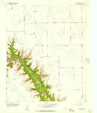 1956 Thomas Ranch1957 Print · USGSThe Texas Panhandle ranching landscape is captured here in the mid-1950s, highlighting the dramatic drop into Palo Duro Canyon. Genealogists and researchers can trace family-named sites like Thomas Ranch, Sorelle Ranch, and Owens Ranch.3 unique versions available
 - 1958 Map of Amarillo
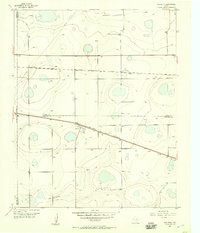
 1958 Amarillo1958 Print · USGSThe Texas Panhandle in the mid-1950s reveals a landscape of expanding military installations and oil-rich rail towns. Local historians can trace the development of Amarillo Air Force Base or locate smaller settlements like Magic City and New Mobeetie.
 - 1958 Map of Plainview
 1958 Plainview1958 Print · USGSThe High Plains and Caprock Escarpment meet in the late fifties, showcasing the ranching and rail networks of the Texas Panhandle. Trace family roots and vanished stops along the Panhandle and Santa Fe railroad through Plainview, Silverton, and Matador.
End of results
Showing maps 1-7 of 7
Top cities of Armstrong County
Frequently asked questions
- What are the different types of historical maps available for Armstrong County?
- What is the oldest map of Armstrong County?
- Where can I purchase historical maps of Armstrong County for my home or office?
- Where can I download high-res historical maps of Armstrong County?
- Are there historical topographic maps available for Armstrong County?
- Is there historical aerial imagery available for Armstrong County?
- Where are historical maps of Armstrong County sourced from?