1920s Maps of Pearland, Texas
Explore 3 historic maps of Pearland from the 1920s. These maps offer a rare glimpse into what life looked like during the 1920s — showing old roads, neighborhoods, homes, and landmarks that have changed or disappeared over time.
Whether you're researching your family's past, planning a metal detecting trip, or studying how Pearland's landscape evolved across the 1920s, these high-resolution maps are a powerful tool for exploring the history of this region.
- Focus on a specific era: All maps on this page are from the 1920s, giving you a focused view of this time period.
- See what’s changed: Compare century-old streets, trails, and buildings to today's modern landscape using overlays and satellite layers.
- Research with precision: Use these maps for genealogy, historical research, land use analysis, or educational projects.
- View, download, or print: Maps are fully viewable online in high resolution, and can be downloaded or printed for your own records.
Start exploring Pearland's history through authentic maps from the 1920s. This is your window into the past.
Pearland, TX maps
(3)- 1920 Map of Genoa
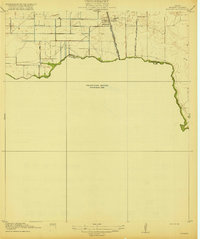
 1920 Genoa1920 Print · USGSSoutheast Texas at the end of the Great War shows a landscape defined by new airfields and electric transit. Genealogists and historians can trace the early rail corridor serving Genoa, the initial layout of Ellington Field, and the crossing at Friendswood Bridge.
 - 1920 Map of Mykawa
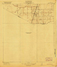
 1920 Mykawa1920 Print · USGSIn the early twentieth century, the Gulf Coast prairie around Mykawa was a landscape of emerging rail stops and rural schoolhouses. Genealogists and historians can trace the early paths of the Houston and Alvin Road and the Minnetex School.3 unique versions available
 - 1920 Map of Almeda
 1920 Almeda1920 Print · USGSHarris County prairie land is captured here during the First World War era, showing a landscape defined by rail and water. Genealogists and researchers can trace the early footprint of Almeda and the path of the International and Great Northern railroad.2 unique versions available
End of results
Showing maps 1-3 of 3
Top cities near Pearland
- Houston historical maps
- Pasadena historical maps
- League City historical maps
- Missouri City historical maps
- Galveston historical maps
- Friendswood historical maps
See more
Top neighborhoods of Pearland
- Hastings historical maps
- Green Tee Terrace historical maps
- Banbury Cross historical maps
- Cabot Cove historical maps
- Canterbury Park historical maps
- Stonebridge historical maps
See more
Frequently asked questions
- What are the different types of historical maps available for Pearland?
- What is the oldest map of Pearland?
- Where can I purchase historical maps of Pearland for my home or office?
- Where can I download high-res historical maps of Pearland?
- Are there historical topographic maps available for Pearland?
- Is there historical aerial imagery available for Pearland?
- Where are historical maps of Pearland sourced from?