1950s Maps of Pearland, Texas
Explore 5 historic maps of Pearland from the 1950s. These maps offer a rare glimpse into what life looked like during the 1950s — showing old roads, neighborhoods, homes, and landmarks that have changed or disappeared over time.
Whether you're researching your family's past, planning a metal detecting trip, or studying how Pearland's landscape evolved across the 1950s, these high-resolution maps are a powerful tool for exploring the history of this region.
- Focus on a specific era: All maps on this page are from the 1950s, giving you a focused view of this time period.
- See what’s changed: Compare century-old streets, trails, and buildings to today's modern landscape using overlays and satellite layers.
- Research with precision: Use these maps for genealogy, historical research, land use analysis, or educational projects.
- View, download, or print: Maps are fully viewable online in high resolution, and can be downloaded or printed for your own records.
Start exploring Pearland's history through authentic maps from the 1950s. This is your window into the past.
Pearland, TX maps
(5)- 1950 Map of Houston, 1953 Print
 1950 Houston1953 Print · USGSCoastal Texas in the early fifties reveals a landscape of massive civil engineering and industrial transit. Genealogists and researchers can trace the growth of the Houston suburbs and the maritime infrastructure of Galveston Bay, including the Gulf Freeway and the Texas City Dike.
 - 1955 Map of Friendswood, 1957 Print
 1955 Friendswood1957 Print · USGSSoutheastern Texas in the mid-fifties reveals an landscape of emerging aviation and oil production. Trace family landmarks and industrial roots at Ellington Air Force Base, the Friendswood Oil Field, and Whitcomb Cem.3 unique versions available
 - 1955 Map of Pearland, 1957 Print
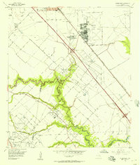
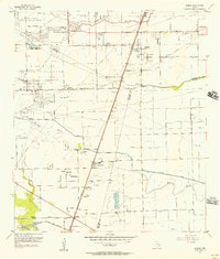
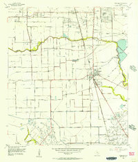 1955 Pearland1957 Print · USGSThe mid-century Texas coastal plain near Pearland reveals a landscape of developing suburbs and active petroleum drilling. Trace the growth of Skyscraper Shadows, locate family sites at Dagg Cem, or study the industrial footprint of the Manvel Field.2 unique versions available
 - 1955 Map of Almeda, 1957 Print
 1955 Almeda1957 Print · USGSIn the mid-fifties, this portion of the Texas coastal plain was a mix of prison farms, oil fields, and rural settlements. Genealogists can locate family names and burial sites at Beth Jacob Cem or Arcola-Fresno Cem and trace the old Missouri Pacific rail corridor.3 unique versions available
 - 1956 Map of Houston, 1963 Print
 1956 Houston1963 Print · USGSSoutheast Texas in the mid-fifties is captured here as a powerhouse of oil and maritime trade. Genealogists and historians can trace the foundations of Houston and its ports, alongside landmarks like the Rice Institute and the Spindletop Oil Field.2 unique versions available
End of results
Showing maps 1-5 of 5
Top cities near Pearland
- Houston historical maps
- Pasadena historical maps
- League City historical maps
- Missouri City historical maps
- Galveston historical maps
- Friendswood historical maps
See more
Top neighborhoods of Pearland
- Hastings historical maps
- Green Tee Terrace historical maps
- Banbury Cross historical maps
- Cabot Cove historical maps
- Canterbury Park historical maps
- Stonebridge historical maps
See more
Frequently asked questions
- What are the different types of historical maps available for Pearland?
- What is the oldest map of Pearland?
- Where can I purchase historical maps of Pearland for my home or office?
- Where can I download high-res historical maps of Pearland?
- Are there historical topographic maps available for Pearland?
- Is there historical aerial imagery available for Pearland?
- Where are historical maps of Pearland sourced from?