1920s Maps of Brooks County, Texas
Explore 3 historic maps of Brooks County from the 1920s. These maps offer a rare glimpse into what life looked like during the 1920s — showing old roads, neighborhoods, homes, and landmarks that have changed or disappeared over time.
Whether you're researching your family's past, planning a metal detecting trip, or studying how Brooks County's landscape evolved across the 1920s, these high-resolution maps are a powerful tool for exploring the history of this region.
- Focus on a specific era: All maps on this page are from the 1920s, giving you a focused view of this time period.
- See what’s changed: Compare century-old streets, trails, and buildings to today's modern landscape using overlays and satellite layers.
- Research with precision: Use these maps for genealogy, historical research, land use analysis, or educational projects.
- View, download, or print: Maps are fully viewable online in high resolution, and can be downloaded or printed for your own records.
Start exploring Brooks County's history through authentic maps from the 1920s. This is your window into the past.
Brooks County, TX maps
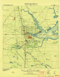
(3)- 1921 Map of Falfurrias
 1921 Falfurrias1921 Print · USGSBrooks and Jim Wells counties were defined by a sprawling ranching and citrus economy in the years following the Great War. Genealogists can trace family holdings and early infrastructure like Coyote Mills, the Concepcion Ruins, and the Seymour Citrus Farm.
 - 1923 Map of Armstrong
 1923 Armstrong1923 Print · USGSSouth Texas cattle country in the early twenties is defined by isolated ranching outposts and the vital rail corridor. Researchers can trace the early footprints of Armstrong and Norias or locate remote landmarks like Lorita Ranch and Chaparrazo Well.
 - 1928 Map of Sarita
 1928 Sarita1928 Print · USGSSouth Texas ranching country and the coastal prairies are shown here during the early twentieth century. Researchers can trace family-named holdings like Kennedy Farm, ranch outposts at Novillos Mott, and rail sidings at Mifflin.
End of results
Showing maps 1-3 of 3
Top cities of Brooks County
Frequently asked questions
- What are the different types of historical maps available for Brooks County?
- What is the oldest map of Brooks County?
- Where can I purchase historical maps of Brooks County for my home or office?
- Where can I download high-res historical maps of Brooks County?
- Are there historical topographic maps available for Brooks County?
- Is there historical aerial imagery available for Brooks County?
- Where are historical maps of Brooks County sourced from?