1930s Maps of Brown County, Texas
Explore 4 historic maps of Brown County from the 1930s. These maps offer a rare glimpse into what life looked like during the 1930s — showing old roads, neighborhoods, homes, and landmarks that have changed or disappeared over time.
Whether you're researching your family's past, planning a metal detecting trip, or studying how Brown County's landscape evolved across the 1930s, these high-resolution maps are a powerful tool for exploring the history of this region.
- Focus on a specific era: All maps on this page are from the 1930s, giving you a focused view of this time period.
- See what’s changed: Compare century-old streets, trails, and buildings to today's modern landscape using overlays and satellite layers.
- Research with precision: Use these maps for genealogy, historical research, land use analysis, or educational projects.
- View, download, or print: Maps are fully viewable online in high resolution, and can be downloaded or printed for your own records.
Start exploring Brown County's history through authentic maps from the 1930s. This is your window into the past.
Brown County, TX maps
(4)- 1930 Map of Richland Springs
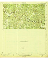 1930 Richland Springs1930 Print · USGSThe Colorado River divides Mills and San Saba counties in the late 1920s, a period defined by small-town farming and ranching. You can trace early family sites through several river crossings and community hubs like Hanna Valley Cem and the Jones Valley Sch.
 - 1931 Map of Mullin
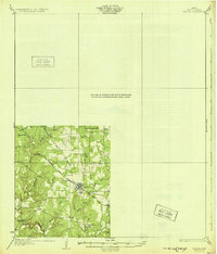 1931 Mullin1931 Print · USGSMills County, Texas, was a landscape of rail-driven trade and rural ranching in the mid-1920s. Genealogists and historians can trace family locations near the Gulf Colorado and Santa Fe railroad, Duren Sch, and the old Williams Ranch.
 - 1931 Map of Baird
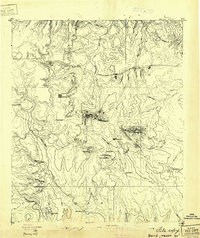 1931 Baird1931 Print · USGSCallahan County ranching and rail life are documented here in the early twentieth century. Genealogists and local historians can trace the foundations of Baird, the Rough Creek P.O., and distinctive landmarks like Caddo Peak and Round Mt.
 - 1932 Map of Baird
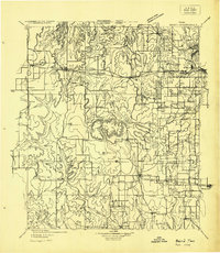 1932 Baird1932 Print · USGSCallahan and Eastland counties appear in the early 1930s, showing the region's transition into the oil and highway era. Genealogists can locate family homes near Belle Plain, Oak Ridge School, and along the Missouri Kansas & Texas railroad.
End of results
Showing maps 1-4 of 4
Top cities of Brown County
Frequently asked questions
- What are the different types of historical maps available for Brown County?
- What is the oldest map of Brown County?
- Where can I purchase historical maps of Brown County for my home or office?
- Where can I download high-res historical maps of Brown County?
- Are there historical topographic maps available for Brown County?
- Is there historical aerial imagery available for Brown County?
- Where are historical maps of Brown County sourced from?