1800s (19th Century) Maps of Brown County, Texas
Explore 8 historic maps of Brown County from the 1800s (19th Century). These maps offer a rare glimpse into what life looked like during the 1800s — showing old roads, neighborhoods, homes, and landmarks that have changed or disappeared over time.
Whether you're researching your family's past, planning a metal detecting trip, or studying how Brown County's landscape evolved across the 1800s, these high-resolution maps are a powerful tool for exploring the history of this region.
- Focus on a specific era: All maps on this page are from the 1800s, giving you a focused view of this time period.
- See what’s changed: Compare century-old streets, trails, and buildings to today's modern landscape using overlays and satellite layers.
- Research with precision: Use these maps for genealogy, historical research, land use analysis, or educational projects.
- View, download, or print: Maps are fully viewable online in high resolution, and can be downloaded or printed for your own records.
Start exploring Brown County's history through authentic maps from the 1800s. This is your window into the past.
Brown County, TX maps
(8)- 1885 Map of San Saba
 1885 San Saba1885 Print · USGSCentral Texas in the late nineteenth century comes alive through this survey of the river valleys and high knobs. Genealogists and researchers can trace the early foundations of San Saba and Goldthwaite, or find forgotten locations like Regency and Bendy.
 - 1887 Map of Coleman, 1889 Print
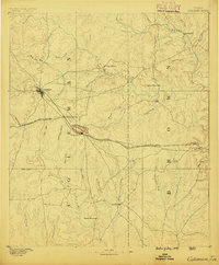 1887 Coleman1889 Print · USGSCentral Texas was undergoing a rapid transformation into a rail-connected ranching hub in the late 1880s. Local researchers can trace the early layout of Coleman and locate frontier landmarks like Camp Colorado, Byrds Store, and the Santa Anna Mountains.2 unique versions available
 - 1889 Map of Brownwood
 1889 Brownwood1889 Print · USGSCentral Texas ranching and rail expansion are captured here in the late nineteenth century. You can trace early family settlements and landmarks like Williams Ranch, Comanche, and the path of the Gulf Colorado and Santa Fe Railroad.
 - 1889 Map of Coleman, 1905 Print
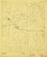 1889 Coleman1905 Print · USGSCentral Texas is captured in the late nineteenth century as the railroad began transforming the frontier into a network of cattle and farming towns. Genealogists can trace early homesteading hubs and remote outposts like Camp Colorado, Byrds Store, and Trickham.4 unique versions available
 - 1894 Map of Brady
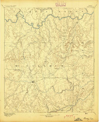 1894 Brady1894 Print · USGSCentral Texas ranching country comes to life in the late nineteenth century as regional hubs begin to take shape. Genealogists and researchers can trace early settlements and river crossings like Waldrip, Milburn, and the hilltop landmark of Lookout Mountain.5 unique versions available
 - 1894 Map of Eastland
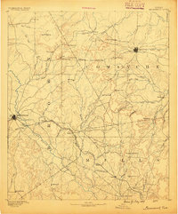
 1894 Eastland1894 Print · USGSEastland County and its neighbors are captured here in the late nineteenth century during the expansion of the rail-and-ranching economy. Researchers can locate early town sites like Desdimonia and Merriman or trace the Texas Central Railroad through Carbon.6 unique versions available
 - 1894 Map of Brownwood
 1894 Brownwood1894 Print · USGSCentral Texas was undergoing a rapid transformation in the late nineteenth century as rail lines began to reshape the cattle country. Researchers can trace the early footprints of Brownwood, locate the historic Williams Ranch, and follow the progress of the Gulf Colorado and Santa Fe Railroad.6 unique versions available
 - 1894 Map of San Saba
 1894 San Saba1894 Print · USGSCentral Texas in the late nineteenth century is defined here by the meeting of the San Saba River and the Colorado River. Researchers can trace the path of the Gulf Colorado and Santa Fe Railroad near Goldthwaite or locate early settlements like Richland Springs and Red Bluff.4 unique versions available
End of results
Showing maps 1-8 of 8
Top cities of Brown County
Frequently asked questions
- What are the different types of historical maps available for Brown County?
- What is the oldest map of Brown County?
- Where can I purchase historical maps of Brown County for my home or office?
- Where can I download high-res historical maps of Brown County?
- Are there historical topographic maps available for Brown County?
- Is there historical aerial imagery available for Brown County?
- Where are historical maps of Brown County sourced from?