1990s Maps of Brown County, Texas
Explore 2 historic maps of Brown County from the 1990s. These maps offer a rare glimpse into what life looked like during the 1990s — showing old roads, neighborhoods, homes, and landmarks that have changed or disappeared over time.
Whether you're researching your family's past, planning a metal detecting trip, or studying how Brown County's landscape evolved across the 1990s, these high-resolution maps are a powerful tool for exploring the history of this region.
- Focus on a specific era: All maps on this page are from the 1990s, giving you a focused view of this time period.
- See what’s changed: Compare century-old streets, trails, and buildings to today's modern landscape using overlays and satellite layers.
- Research with precision: Use these maps for genealogy, historical research, land use analysis, or educational projects.
- View, download, or print: Maps are fully viewable online in high resolution, and can be downloaded or printed for your own records.
Start exploring Brown County's history through authentic maps from the 1990s. This is your window into the past.
Brown County, TX maps
(2)- 1996 Map of Brownwood, 1998 Print
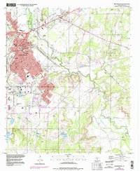 1996 Brownwood1998 Print · USGSBrownwood and the surrounding central Texas countryside are shown in the late 1990s as the urban center expanded toward Early. Local historians can trace family ties at Greenleaf Cemetery or locate the historic Williams Ranch Road and Bowie Memorial Airpark.2 unique versions available
 - 1997 Map of Indian Creek, 1998 Print
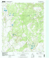 1997 Indian Creek1998 Print · USGSCentral Texas rural life and military land use are documented here in the late twentieth century. Genealogists can trace family sites at Indian Creek Cem and Elkins Cem or explore the area around Ebony.
End of results
Showing maps 1-2 of 2
Top cities of Brown County
Frequently asked questions
- What are the different types of historical maps available for Brown County?
- What is the oldest map of Brown County?
- Where can I purchase historical maps of Brown County for my home or office?
- Where can I download high-res historical maps of Brown County?
- Are there historical topographic maps available for Brown County?
- Is there historical aerial imagery available for Brown County?
- Where are historical maps of Brown County sourced from?