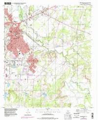
1996 Map of Brownwood
USGS Topo · Published 1998About this map
Pecan Bayou winds through this central Texas landscape, separating the established city of Brownwood from its neighbors Early and Woodland Heights. The map reflects a mid-to-late 20th-century urban environment, featuring the campus of Howard Payne University and significant athletic landmarks like Longhorn Stadium and Lion Stadium. To the south, the Camp Bowie Reservoir and Bowie Memorial Airpark suggest the area's historical military and aviation footprint. The surrounding terrain is marked by numerous Gravel Pits and family-named cemeteries such as Connell Cem and Beairds Cem, which provide essential points of reference for genealogists. The presence of the U S Dept Agr Exper Sta near the bayou highlights the region's long-standing connection to agricultural research and development alongside its growing suburban infrastructure.
Find a feature on this map
45 named features on this map. Tap any name to fly to it.
Don’t see what you’re looking for? This feature index may not catch every label — zoom into the map to look around manually.
Map Details
Editions of this 1996 Brownwood Map
2 editions found
Other maps of this area

1887 · Coleman
USGS Topo · 1:125,000

1889 · Brownwood
USGS Topo · 1:125,000

1889 · Coleman
USGS Topo · 1:125,000

1894 · Brownwood
USGS Topo · 1:125,000

1924 · Brownwood Reservoir Site
USGS Topo · 1:48,000

1925 · Brownwood 3-b
USGS Topo · 1:48,000

1925 · Brownwood 3-d
USGS Topo · 1:48,000

1927 · Grosvenor
USGS Topo · 1:62,500

1928 · Zephyr
USGS Topo · 1:62,500

1950 · Zephyr
USGS Topo · 1:62,500